
Mitchell CAD Property Search, Forms, Online Appeals, Tax Office and Payment Help
Mitchell County property records can involve Colorado City homes, Loraine property, Westbrook property, rural land, business personal property, agricultural appraisal, tax-due accounts, and school or groundwater district taxing units. The fastest way to avoid mistakes is to know whether your question belongs to the appraisal district or the tax office.
Mitchell CAD handles appraised value, property search, exemptions, forms, renditions, online appeals, truth in taxation, and appraisal questions. Mitchell County Tax Office handles tax bills, online payments, receipts, balances, taxpayer portal access, and collection questions.
Quick Answer for Mitchell County Property Owners
Start with Mitchell CAD if your question is about appraised value, market value, property search, owner lookup, address lookup, property ID search, exemptions, agricultural appraisal, renditions, online appeals, appraisal notices, forms, or appraisal review.
Start with Mitchell County Tax Office if your question is about property tax payment, tax receipt, tax bill, tax balance, online payment, taxpayer portal, vehicle registration, or collection matters.
Official Mitchell CAD and County Tax Resources
Use official links first. This helps you avoid old forms, wrong phone numbers, stale property pages, unsafe payment links, and third-party data that may not match the live appraisal or tax record.
| Need | Official Resource | Use It For |
|---|---|---|
| CAD homepage | Mitchell County Appraisal District | Property search, forms, online appeals, truth in taxation, links, contact form, customer survey, calendars, tax rates, and appraisal district resources. |
| Property search | Mitchell CAD Property Search | Search by Owner, Address, ID, or Advanced Search. Use simpler names or street names when search results are difficult. |
| Forms | Mitchell CAD Forms | Homestead, disabled veteran, agricultural appraisal, timber appraisal, personal property rendition, real estate rendition, and special inventory forms. |
| Online appeals | Mitchell CAD Online Appeals | File or manage eligible appraisal protests/appeals online when your notice or account allows it. |
| Truth in taxation | Mitchell CAD Truth in Taxation | Access local property tax database information and proposed tax-rate transparency resources. |
| Tax payment | Mitchell County Tax Office | Property search, online payments, tax forms, online map search, taxpayer portal, vehicle registration, and tax office contact details. |
| Online tax search/payment | Mitchell County Tax Search & Payments | Search property tax records, verify balances, pay online, and review payment details. |
| State verification | Texas Comptroller Mitchell Directory | Cross-check chief appraiser, CAD phone, CAD email, CAD address, Tax Assessor-Collector, tax office phone, and active taxing units. |
How to Search Mitchell County Property Records
Mitchell CAD’s official search is useful for homeowners, buyers, real estate agents, businesses, ranch owners, and anyone checking an appraisal notice. The portal gives the fastest results when you use the right search field instead of repeating a full address or full owner name that may not match.
Open the official Mitchell CAD property search
Start at esearch.mitchellcad.org or go through mitchellcad.org and click Property Search.
Choose Owner, Address, ID, or Advanced Search
Use Owner if you know the owner name, Address if the property has a clear situs address, ID if you have the property/account number, and Advanced Search when your first result list is too broad.
Search simple before searching exact
If address search fails, try only the street name. If name search fails, try only the first or last name. This matches the official search guidance and avoids missing records due to formatting.
Open the full property card
Review owner name, property ID, mailing address, situs address, legal description, land details, improvements, exemptions, appraised value, market value, prior year value, and taxing units.
Use tax office search only for tax bill questions
If you need payment status, tax balance, receipt, or delinquent amount, use the Mitchell County Tax Office search instead of the CAD record alone.
Save proof before calling or filing
Save a screenshot or PDF of the CAD property record before filing a form, starting an appeal, calling the office, or comparing your tax bill.
Mitchell County search tip: Colorado City properties may work by address, but rural land, Loraine-area property, Westbrook-area property, business personal property, agricultural accounts, and groundwater-district properties may require property ID, owner name, legal description, map search, or Advanced Search.
Use the Existing Mitchell CAD Image as a Practical Search Reminder
The current article already includes a Mitchell CAD property search image. This replacement keeps that image inside the search workflow where it helps readers understand the official property search route.
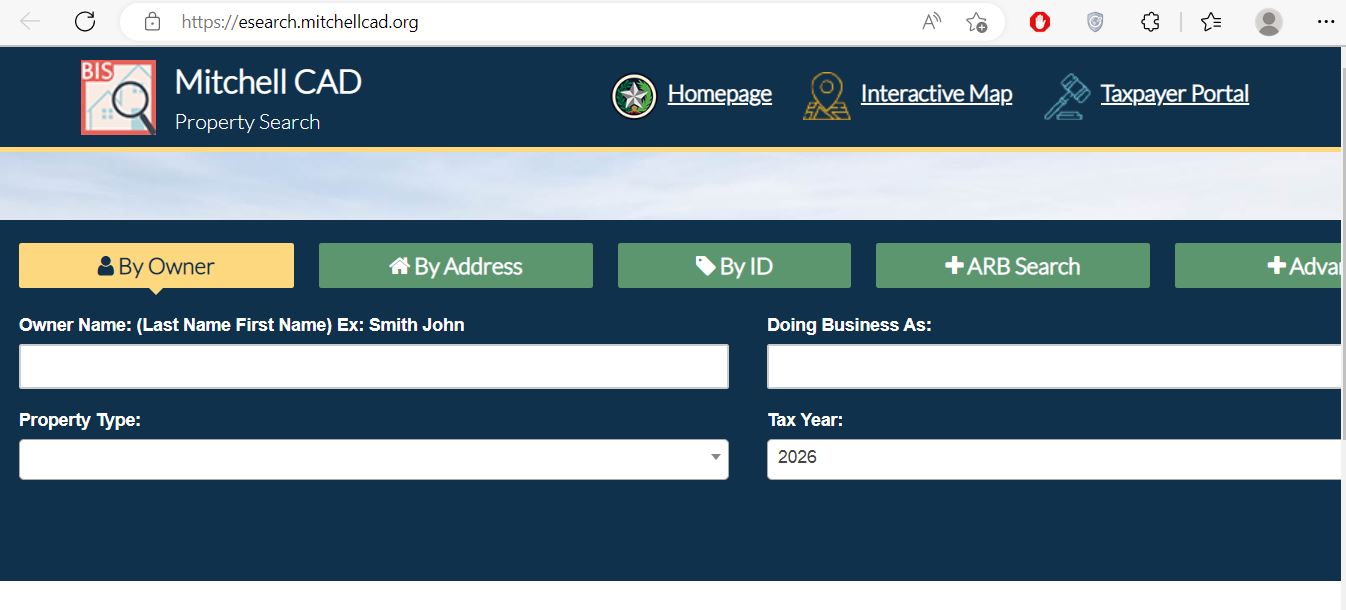
Image note: Treat this screenshot as a navigation reminder only. Search screens, tax years, values, exemptions, online appeals, and property details can change. Always confirm the live record directly on the official Mitchell CAD website.
Mitchell CAD Forms: Homestead, Ag, Rendition, Timber and Special Inventory
Mitchell CAD’s official forms page includes common property-tax forms used by homeowners, disabled veterans, agricultural landowners, timber landowners, business owners, real estate owners, and special inventory taxpayers.
| Situation | Best Starting Point | What to Prepare |
|---|---|---|
| You live in the home as your primary residence | Residence homestead exemption | Property ID, owner name, property address, Texas driver license or state ID, matching address, and correct tax year. |
| You are a disabled veteran or qualifying survivor | Disabled veteran exemption | Ownership details, ID, veteran/disability documents, award letter or required proof, and property account details. |
| You own farm, ranch, open-space, or timber land | Agricultural appraisal or timber land appraisal | Land-use history, acreage details, production records, leases, grazing/crop details, maps, photos, and supporting documents. |
| You own taxable business assets | Personal property rendition | Asset list, equipment details, inventory, acquisition costs, business location, owner information, and prior-year rendition if available. |
| You need to report real property inventory | General real estate rendition or real property inventory rendition | Property account, ownership details, inventory details, condition notes, improvement details, and supporting records. |
| You operate special inventory | Dealer motor vehicle inventory declaration or tax statement | Dealer inventory details, monthly sales reports, tax statements, prepayment records, and account information. |
Form filing tip: Save a copy of every signed form, supporting document, email receipt, upload confirmation, certified mail receipt, or office-stamped copy. If a deadline or missing-document issue comes up later, proof of submission matters.
Mitchell County Property Tax Payment: Use the Tax Office Route
Mitchell CAD appraises property. Mitchell County Tax Office collects for Mitchell County, Colorado ISD, Loraine ISD, Westbrook ISD, City of Colorado City, City of Loraine, City of Westbrook, Lone Wolf Groundwater Conservation District, and Mitchell County Hospital District.
Open the official Mitchell County Tax Office website
Go to mitchellcounty.tax for property search, online payments, tax forms, online map search, taxpayer portal, and office contact details.
Use the official tax search/payment portal
Open Mitchell County property tax search and online payments to search property tax records and pay when available.
Match the property before paying
Confirm owner name, property account, legal description, tax year, taxing unit, amount due, payment method, convenience fee, and receipt details before submitting payment.
Separate value questions from payment questions
If the value looks wrong, contact Mitchell CAD. If the tax bill, receipt, payment posting, delinquent amount, or statement looks wrong, contact the Mitchell County Tax Office.
Save payment proof
Keep the confirmation number, receipt screenshot, payment date, amount paid, account number, and payment method. This helps if the balance does not update immediately.
Payment warning: Do not pay from sponsored ads, text-message links, copied payment pages, or email links. Start from the official Mitchell County Tax Office website before submitting money.
How to Prepare a Mitchell CAD Online Appeal or Protest
A good appeal focuses on the appraisal issue, not only the final tax bill. Mitchell CAD can review market value, unequal appraisal, wrong property details, missing exemption, agricultural appraisal, business personal property, inventory, land classification, and condition issues.
Read your Notice of Appraised Value first
Check property ID, owner name, proposed value, prior value, exemption status, deadline, appeal instructions, online appeal details, and any account or PIN requirements.
Compare the property record line by line
Look for wrong square footage, incorrect land size, wrong property class, missing exemption, old mailing address, extra improvements, wrong condition, or business asset mistakes.
Collect evidence that supports your reason
Useful evidence can include comparable sales, photos, repair estimates, closing documents, private appraisal, unequal appraisal examples, maps, lease records, agricultural evidence, or business asset lists.
Use online appeals when eligible
Mitchell CAD links to Online Appeals. File early enough to avoid last-minute login, upload, or deadline problems.
Keep proof of filing and upload
Save screenshots, email confirmations, upload records, certified mail receipts, or office-stamped copies. Label each evidence file clearly.
Deadline warning: Always confirm the protest or appeal deadline on your official appraisal notice or directly with Mitchell CAD. A strong evidence packet will not help if the appeal is filed late.
Rural Land, Business Personal Property, Tax Due and Special Searches
Mitchell County property research can involve homes, rural tracts, farm/ranch land, business assets, dealer inventory, properties with tax due, school district accounts, city taxing units, groundwater district tax areas, and hospital district tax areas. One search method may not find every record.
Practical tip: If your property is tied to Loraine ISD, Westbrook ISD, Colorado ISD, a city taxing unit, Lone Wolf Groundwater Conservation District, or Mitchell County Hospital District, compare CAD value details with the tax office statement before estimating your final bill.
Mitchell CAD, Tax Office or County Clerk: Who Handles What?
Many users search “Mitchell County property records” but need different offices depending on whether the issue is value, payment, ownership, or recorded legal documents.
| Your Question | Best Starting Point | Why |
|---|---|---|
| What is my appraised value? | Mitchell CAD | The appraisal district determines market value and maintains appraisal records. |
| Where do I search by owner, address, ID, or advanced filters? | Mitchell CAD Property Search | The official search portal is the main appraisal-record lookup tool. |
| Where do I file homestead, disabled veteran, ag, timber, rendition, or inventory forms? | Mitchell CAD Forms | Exemptions, renditions, special appraisal, and appraisal filings are appraisal district matters. |
| Where do I file an appraisal appeal or protest? | Mitchell CAD Online Appeals or Notice of Protest form | Appraisal appeals and ARB-related matters are handled through the appraisal district. |
| Where do I pay property taxes? | Mitchell County Tax Office | Tax bills, payments, receipts, balances, taxpayer portal, and collection questions are tax office matters. |
| Where do I get deeds, liens, plats, or recorded documents? | Mitchell County Clerk | Recorded legal documents are separate from CAD appraisal records. |
Common Mitchell CAD Search Problems and Fixes
| Problem | Likely Reason | Try This |
|---|---|---|
| Owner name is not found | Wrong name order, trust name, estate name, company name, spouse name, or spelling difference. | Use just first or last name, business keyword, property ID, or Advanced Search. |
| Address search gives no result | Address formatting, rural property, county-road issue, old situs address, or non-standard property location. | Use only the street name, property ID, owner name, legal description, or Advanced Search. |
| Tax bill does not match CAD value | Tax bills depend on tax rates, exemptions, taxing units, payment status, penalties, and collection data. | Verify appraised value with CAD and payment/balance details with the Mitchell County Tax Office. |
| Exemption is missing | Application may not be filed, complete, approved, or applied to the correct tax year. | Check the official forms page, save filing proof, and contact CAD with your property ID ready. |
| Business assets are valued too high | Personal property rendition may be missing, incomplete, outdated, or unsupported. | Prepare asset list, acquisition dates, depreciation details, inventory data, and supporting documents before contacting CAD. |
| Tax payment did not update | Online payment may need processing time or the wrong account may have been selected. | Check your receipt and contact Mitchell County Tax Office with account number, confirmation number, date, and amount. |
Documents to Keep Ready Before Calling
Mitchell CAD and the tax office can help faster when you provide the correct account details and explain the exact issue.
- Owner name shown on the CAD record
- Property ID, account number, or legal description
- Property address, street name, or rural location details
- Tax year and Notice of Appraised Value
- Photos, sales proof, repair estimates, ag-use records, business asset lists, or exemption documents
- Screenshot or PDF of the CAD record before you call
- Tax year and amount due
- Property account number or tax statement
- Owner name and mailing address
- Payment confirmation or receipt if already paid
- Screenshot of the payment screen if something looks wrong
- Any mailed tax bill, delinquent notice, or tax office communication
Mitchell CAD Phone, Address, Tax Office and Map
Colorado City, TX 79512-3448
Phone: 325-728-5028
Fax: 325-728-8024
Email: mitchellcad1@outlook.com
Chief Appraiser: Lizz Shankles
Office Hours: Monday-Friday, 8:30 AM-5:00 PM
438 East Second Street
Colorado City, TX 79512
Phone: 325-728-2606
Fax: 325-728-3963
Email: thughes@co.mitchell.tx.us
Hours: Monday-Friday, 8:00 AM-5:00 PM
Visit tip: Mitchell CAD and Mitchell County Tax Office are different offices. If you need value, exemption, appraisal, form, or appeal help, contact CAD. If you need payment, receipt, taxpayer portal, or tax bill help, contact the Tax Office.
Mitchell County Appraisal District FAQs
What is the official Mitchell County Appraisal District website?
The official website is mitchellcad.org. Use it for property search, forms, online appeals, truth in taxation, contact details, and appraisal district resources.
How do I search Mitchell County property records?
Use the official Mitchell CAD property search. You can search by Owner, Address, ID, or Advanced Search.
Where is Mitchell County Appraisal District located?
Mitchell County Appraisal District is located at 2112 Hickory Street, Colorado City, Texas 79512.
What is the Mitchell CAD phone number?
The Mitchell CAD phone number is 325-728-5028. The Texas Comptroller directory lists the fax number as 325-728-8024 and the email as mitchellcad1@outlook.com.
Who is the Mitchell County chief appraiser?
The Texas Comptroller county directory lists Lizz Shankles as Chief Appraiser for Mitchell County Appraisal District.
Where do I get Mitchell CAD forms?
Use the official Mitchell CAD Forms page for homestead exemption, disabled veteran exemption, agricultural appraisal, timber appraisal, renditions, and special inventory forms.
Can I file a Mitchell CAD protest or appeal online?
Yes. Mitchell CAD lists Online Appeals as an official service. Use Mitchell CAD Online Appeals when your property account is eligible and always follow your notice deadline.
Does Mitchell CAD collect property tax payments?
Mitchell CAD handles appraisal records, values, exemptions, forms, and appeals. Mitchell County Tax Office handles property tax payments, receipts, balances, and collection matters.
Where do I pay Mitchell County property taxes online?
Use the official Mitchell County Tax Office website or its property search and online payments portal. Confirm the account and tax year before paying.
Is AppraisalDistrict.org the official Mitchell CAD website?
No. AppraisalDistrict.org is an independent informational guide. Always verify values, exemptions, tax bills, payment status, appeal deadlines, forms, maps, and office procedures with Mitchell CAD, Mitchell County Tax Office, or Texas Comptroller resources.
Independent Guide and Verification Note
AppraisalDistrict.org is not the official Mitchell County Appraisal District website. This page is an independent public guide created to help users find official resources faster and understand which office handles which task.
Always confirm appraised values, exemptions, appeal deadlines, property records, business personal property records, tax bills, tax rates, payment status, GIS/map information, forms, and office procedures directly with Mitchell CAD, Mitchell County Tax Office, or Texas Comptroller resources before taking action.

Founded by Mahesh Kumar, AppraisalDistrict.org is built on the belief that public information should be accessible and accurate. We have replaced AI-generated ‘fluff’ and automated scraping with 100% manual human verification. With over 15 years of experience in real estate and digital journalism, we help you find the right data without the frustration of broken links.
Search Smarter, Estimate Taxes, Check Exemptions and Prepare for a Protest
Use this free tool before you visit a county appraisal district, property search portal, tax office, or exemption page. It helps you understand property value, taxable value, possible savings, protest value, and the next official step.
What do you need help with today?
Choose your main reason for visiting. The tool will show the best next step and quick estimate.
Use this tool to check your appraisal notice, exemption savings, protest value, and official next step.
Use the tax calculator before trusting only the sale price or mortgage estimate.
Property Search Helper
Use this when a county property search portal is confusing. It shows which search method is usually best.
Property Tax Estimate Calculator
Estimate annual property tax using appraised value, assessment ratio, exemptions, and combined tax rate.
Homestead and Exemption Savings
Estimate how much a homestead, senior, disability, veteran, or local exemption may reduce tax.
Appraisal Notice Review
Compare last year value with this year value and see whether the increase deserves closer review.
Property Tax Protest Savings
Estimate possible savings if your appraised value is reduced after protest, correction, evidence review, or appraisal review board hearing.
Property Tax Protest and Exemption Checklist
Use this checklist before you file a protest, apply for exemption, or call the appraisal district.
Before calling, write your property ID, owner name, property address, and question on paper. It saves time.
Do not call the CAD to pay tax bills unless the local article says they collect taxes. In many counties, the tax office collects payment.
Official Resource Finder
Enter county and state to create safe searches for official CAD pages, property search, tax payment, exemptions, maps, forms, and protest help.
CAD vs Tax Office
- Appraisal District: value, exemptions, ownership records, maps, protest.
- Tax Office: tax bill, payment, receipt, delinquent balance, penalty.
Best place to use this
Add this tool after the first major content section or before the FAQ area. It gives visitors a reason to interact before leaving the page.
Important estimate note
This tool gives educational estimates only. Final values, exemptions, tax rates, bills, payments, and deadlines must be confirmed with official county sources.