Verify a Hudspeth County Desert Parcel Before You File or Pay
Hudspeth Appraisal District provides the county’s property search, appraisal records, maps, exemptions, agricultural applications, protest forms and property-tax collection. Rural parcels often require an abstract, legal description, owner ID or Geographic ID instead of an ordinary street address.
This guide shows how to identify the correct account, compare desert and irrigated acreage, review the active taxing units, prepare a 2026 protest, obtain recorded land documents and complete a Certified Payments transaction without contacting the vehicle-registration office by mistake.
Adolfo M. Ramirez, RPA
103 Millican Street, Sierra Blanca
Hudspeth Appraisal District
Certified Payments bureau code 3694118
2025 annual and mass appraisal reports
Which Hudspeth County property service do you need?
This browser tool does not collect or transmit owner names, appraisal values, property IDs, balances or payment information.
Use Owner, Address, ID or Advanced Search and verify the tax year and property type.
Follow the search walkthroughUse legal information and the map when a county-road or postal address does not identify the tract.
Review the rural-land workflowDownload the current district form, attach the required evidence and retain proof of delivery.
Open forms and evidence stepsUse the account-specific deadline and the 2026 hearing notice rather than an old generic calendar.
Prepare a protest fileVerify bureau code 3694118 and allow for the district’s published posting delay.
Follow payment stepsUse the County and District Clerk because a CAD owner field is not legal title.
Review land-record optionsSearch Hudspeth CAD with the strongest identifier available
Prepare these details before searching
Recognise the official Hudspeth CAD search screen
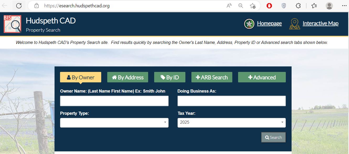
Enter the surname first or use only one name.
Start with the main street or road word.
Use Property ID, Owner ID or Geographic ID.
Search abstract, subdivision, neighbourhood and protest fields.
Understand what the Hudspeth CAD record proves
| Record field | What it identifies | What it does not prove | Best next action |
|---|---|---|---|
| Property ID | The Hudspeth CAD appraisal and collection account. | A deed instrument number. | Use it for forms, protests and payment questions. |
| Owner ID | An owner record connected to one or more accounts. | That every result is the same tract or property type. | Review every connected account. |
| Geographic ID | A mapping and geographic reference. | A surveyed boundary or legal access. | Compare the GIS map, deed and survey. |
| Owner name | The owner displayed for appraisal administration. | Complete title, heirship or mineral ownership. | Check County and District Clerk records. |
| Situs or property address | The location used by the appraisal system. | A county-assigned 911 address, legal access or mailing delivery. | Compare county 911 and road records. |
| Legal description | An abstract, survey, tract, block, lot or subdivision reference. | Every boundary call, easement, reservation or exception. | Obtain the recorded document and survey. |
| Acreage | The acreage used in appraisal administration. | Surveyed acreage or fence location. | Compare the deed, survey and neighbouring records. |
| Market value | The district’s January 1 market-value estimate. | Purchase price, taxable value or tax amount. | Review land characteristics and comparable evidence. |
| Productivity value | A special appraisal for qualifying agricultural or open-space land. | Future qualification after a sale or land-use change. | Review the application and use history. |
| Taxing units | County, school, city, water and emergency-service entities. | That nearby tracts have the same combination. | Use only the entities shown on the exact account. |
Fix a missing or confusing Hudspeth County result
| Problem | Likely reason | Practical fix |
|---|---|---|
| Complete owner name returns nothing | The account may use surname-first format, initials, a trust, estate or former owner. | Search only the surname or one distinctive business word. |
| Street address fails | The parcel may use a rural, private-road, highway or nonstandard situs description. | Search only the street word, owner, Property ID or legal description. |
| Remote desert tract has no address | The account may be indexed by abstract, survey, Geo ID or owner. | Use Advanced Search and the official GIS map. |
| Dell City acreage is difficult to distinguish | One owner may have several irrigated parcels or accounts. | Compare Property ID, abstract, acreage and taxing units. |
| Mobile home is missing | The home may have a separate account or park classification. | Use the MobileHomePark field and change property type. |
| Recent buyer is not displayed | The recorded deed or CAD ownership update may still be processing. | Confirm recording and provide instrument information to CAD. |
| Exemption or agricultural value is missing | The application may be pending, incomplete, denied or tied to another year. | Provide the application and delivery proof to the district. |
| Online payment has not posted | Hudspeth CAD states that online or phone payments may take up to 14 days to appear. | Keep the confirmation and call before paying twice. |
Build a parcel inventory before comparing rural values
Review legal access, terrain, distance to utilities, road condition, flood or drainage features and improvement status.
Compare irrigation, wells, crop use, productivity appraisal, groundwater-district taxation and parcel configuration.
Verify access, frontage, easements, legal description, development restrictions and exact taxing entities.
Adjust the workflow to the community and taxing units
Verify Sierra Blanca ISD, county taxation, ESD coverage, physical address and town-lot legal description.
Check City of Dell City, Dell City ISD, groundwater district, irrigation features and agricultural appraisal.
Verify Fort Hancock ISD, Fort Hancock WCID #1, ESD coverage and legal access.
The 2025 rate sheet includes Culberson County–Allamoore ISD. Use the exact school district shown on the account.
Use the abstract, survey, Geo ID and map because postal or community names may not identify the parcel.
Confirm school, water and emergency-service entities instead of relying on a mailing city.
Investigate access, road maintenance, utilities, flood routes, topography and recorded restrictions before comparing value.
Determine whether the home and land use separate accounts and whether a mobile-home park field is required.
Search seller and buyer names, confirm deed recording, update the mailing address and verify any agricultural application.
Use Hudspeth CAD’s current form and retain delivery proof
| Situation | Starting form | What to prepare |
|---|---|---|
| Primary residence | Residence Homestead Exemption | Property ID, ownership, occupancy, identification and address information. |
| Disabled veteran | Disabled Veteran’s Exemption | VA documentation, ownership and eligibility records. |
| Qualifying agricultural land | Agricultural Appraisal | Acreage, use history, leases, production records, maps and photographs. |
| Business assets | Personal Property Rendition | Asset list, costs, acquisition dates, inventory and leased property. |
| Real-property rendition | General Real Estate Rendition | Owner, legal description, location and property details. |
| Rendition extension | Business Personal Rendition Extension | Account, owner, written request and current filing instructions. |
| Appraisal dispute | Notice of Protest | Notice, Property ID, protest ground and evidence. |
| Vehicle, vessel or heavy-equipment dealer | Matching Special Inventory Declaration and Tax Statement | Inventory, sales records and monthly statements. |
Prepare an asset-level rendition for Hudspeth County
Hudspeth CAD publishes ordinary personal-property renditions, real-estate renditions, an extension form and specialised dealer inventory forms for motor vehicles, vessels, outboard motors, heavy equipment and manufactured housing.
| Information | Why it matters | Useful evidence |
|---|---|---|
| Owner and DBA | Connects assets to the correct business and location. | Entity records, prior account and operating address. |
| Machinery and equipment | Identifies taxable income-producing assets. | Description, acquisition year, cost and condition. |
| Inventory | Inventory may require separate reporting or special-inventory treatment. | Representative inventory and accounting records. |
| Leased property | The user and legal owner may be different parties. | Lease agreement, lessor and property location. |
| Disposed or relocated property | An old asset list can overstate property remaining in the county. | Sale, disposal, transfer and relocation records. |
| Solar, utility or field equipment | Remote equipment can be located separately from the main office. | Site list, serial numbers, maps and ownership records. |
Challenge the exact appraisal issue with property-specific evidence
| Property type | Useful evidence | Weak comparison |
|---|---|---|
| Sierra Blanca residence | Comparable town sales, measurements, condition photographs and repair estimates. | Remote vacant desert acreage. |
| Dell City irrigated farm | Irrigation, well, crop, productivity, access and soil information. | Non-irrigated desert tract. |
| Remote desert parcel | Legal access, road quality, terrain, utilities, distance, survey and comparable remote tracts. | Accessible highway-front property. |
| Agricultural or grazing land | Use history, leases, livestock, production, fencing, water and maps. | Acreage alone. |
| Business personal property | Asset ledger, costs, acquisition years, leased assets and disposals. | One unsupported total. |
| Mobile home or improvement | Serial data, ownership, location, condition and land-account relationship. | Land value alone. |
Pay Hudspeth County property taxes through Hudspeth CAD
Use the 2025 entity rates for historical comparison
| Taxing entity | 2025 rate | Property check |
|---|---|---|
| Hudspeth County | 0.562370909 | County taxable value and exemptions |
| Culberson County–Allamoore ISD | 0.9600 | Only accounts assigned to this cross-county school district |
| Dell City ISD | 0.6822 | Verify the school boundary |
| Fort Hancock ISD | 0.7172 | Includes published M&O and I&S components |
| Sierra Blanca ISD | 1.1022 | Includes published M&O and I&S components |
| City of Dell City | 0.5901488 | Only property inside the city |
| Hudspeth County ESD #1 | 0.0944 | Verify the ESD boundary |
| Hudspeth County ESD #2 | 0.088370 | Verify the ESD boundary |
| Fort Hancock WCID #1 | 0.4430 | Only where the water-control district appears |
| Hudspeth County Underground Water Conservation District #1 | 0.2771 | Taxing status does not prove a water right or permit |
County + Sierra Blanca ISD = 1.664570909 per $100 before any applicable ESD or other entity.
County + Dell City ISD + City of Dell City + groundwater district = 2.111819709 per $100 before any applicable ESD.
County + Fort Hancock ISD + WCID #1 = 1.722570909 per $100 before an applicable ESD.
Use the County and District Clerk for legal ownership records
Brenda Sanchez
Hudspeth County Courthouse109 Millican Street
Sierra Blanca, Texas 79851
Mailing: P.O. Box 58, Sierra Blanca, TX 79851
915-369-2301
Fax: 915-369-0055
bsanchez@co.hudspeth.tx.us
Monday–Friday, 8:00 AM–5:00 PM.
Closed from 12:00 PM–1:00 PM.
Call before travelling for certified documents, older maps, records outside the historic online range or a time-sensitive filing.
Do not confuse appraisal records with county development approval
| Task | Official starting point | Why the CAD record is not enough |
|---|---|---|
| Request a physical 911 address | County 911/Physical Address Application | A CAD situs field does not necessarily prove an assigned emergency-service address. |
| Build or develop land | Development Permit Application | Appraisal ownership and value do not authorise construction or site work. |
| Create or change a subdivision | Subdivision process and application | CAD parcel lines are not approval of a subdivision or plat. |
| Name a road | Road Naming Order and Application | A private or informal road label may not be a county-approved road name. |
| Install an on-site sewage facility | Hudspeth CAD Public Information OSSF section | A property account does not establish septic suitability or permit approval. |
| Use a county road for special activity | Special Road Use Permit | Ownership beside a road does not authorise special use of county right-of-way. |
Contact the Hudspeth County office that controls the issue
Use for property search, appraisal values, exemptions, agricultural appraisal, renditions, protests, maps, tax balances, payments and receipts.
103 Millican StreetSierra Blanca, Texas 79851
Mailing: P.O. Box 429, Sierra Blanca, TX 79851-0429
915-369-4118
Fax: 915-369-3621
hudspethappraisaldistrict@yahoo.com
Chief Appraiser: Adolfo M. Ramirez, RPA
Hours: Monday–Thursday, 8:00 AM–5:00 PM; Friday, 8:00 AM–4:00 PM.
Deputy Tax Collector/Office Manager: Camila S. Lawson, RTC.
Certified Payments:
866-539-2020
Bureau code: 3694118
Hudspeth CAD states that online and telephone payments may take up to 14 days to reflect.
Use for vehicle registration and other county Tax Office services—not property-tax collection.
109 Brown StreetSierra Blanca, Texas 79851
Mailing: P.O. Box 158, Sierra Blanca, TX 79851
Patricia Rose
915-369-2331
Fax: 915-369-3005
pjrose@co.hudspeth.tx.us
Hours: Monday–Friday, 8:00 AM–5:00 PM.
- Property ID, Owner ID or Geo ID
- Owner and prior owner names
- Property type and tax year
- Abstract, survey and legal description
- Appraisal notice or tax statement
- Form, protest or payment confirmation
- The exact correction or question
Open the exact Hudspeth County property resource
Current district notices, organisation, appraisal information and contact details.
Open Hudspeth CADSearch owner, address, IDs, abstract, subdivision, neighbourhood and ARB fields.
Open Property SearchReview approximate desert, rural and irrigated parcel locations.
Open Interactive MapHomestead, veteran, agricultural, rendition, special inventory and protest forms.
Open FormsCertified Payments, telephone, mail, bureau code and posting information.
Open Payment InstructionsReview the district’s published appraisal-review hearing dates.
Open ARB DatesTax rates, open records, tax certificates, OSSF, land maps and taxpayer notices.
Open Public InformationReview the 2025 annual report and mass appraisal report.
Open Appraisal ReportsReview proposed and adopted rate information during the tax-rate process.
Open Tax NoticesHistoric land records, current recording help, deeds, maps and probate records.
Open Clerk911 addresses, development permits, subdivisions and road applications.
Open County FormsVerify CAD, Tax Assessor-Collector and active taxing-unit information.
Open Comptroller DirectoryHudspeth County Appraisal District FAQs
What is the official Hudspeth County Appraisal District website?
The official website is hudspethcad.org. Use it for property search, maps, forms, payment instructions, ARB dates, tax rates and district contact information.
How do I search Hudspeth County property records?
Use Hudspeth CAD Property Search. Search by owner, address, Property ID, Owner ID, Geographic ID, abstract, subdivision, neighbourhood or Advanced Search.
Who is the Hudspeth County Chief Appraiser?
Hudspeth CAD and the county directory identify Adolfo M. Ramirez, RPA as Chief Appraiser.
Where is Hudspeth Appraisal District located?
The office is at 103 Millican Street, Sierra Blanca, Texas 79851. The mailing address is P.O. Box 429, Sierra Blanca, Texas 79851-0429.
Who collects Hudspeth County property taxes?
Hudspeth Appraisal District provides property-tax collection for county entities. The Hudspeth County Tax Assessor-Collector does not collect property taxes and mainly handles vehicle-registration services.
What is the Hudspeth CAD payment bureau code?
The district currently publishes Certified Payments bureau code 3694118. Telephone payments are made through Certified Payments at 866-539-2020.
How long can an online Hudspeth County tax payment take to appear?
Hudspeth CAD states that online and telephone payments may take up to 14 days to reflect. The payment is applied using the date it was made, so keep the confirmation and call before paying again.
What are the 2026 Hudspeth CAD ARB hearing dates?
The district lists July 9, July 23, August 13 and August 27, 2026. Use the property’s official hearing notice to confirm its assigned date and time.
Where can I find Hudspeth County deeds and land records?
Use the Hudspeth County and District Clerk. The county provides online historic index books and associated land records from 1884 through 1988; contact the Clerk for later or certified documents.
Does the Hudspeth CAD map prove acreage, access or property boundaries?
No. The CAD map, legal summary and acreage are appraisal research tools. Use deeds, recorded easements, county road records and a licensed surveyor when boundaries or access matter.