
Follow a Panola County Property From Pine Tract or Mineral Account to the Correct Official Record
Panola CAD covers more than houses and city lots. Its database includes rural acreage, qualified timberland, agricultural land, oil and gas interests, utilities, industrial property, manufactured homes and business personal property.
Use this guide to choose the correct search tab, interpret market and productivity values, verify exemptions, prepare a protest, pay the correct tax account and research the recorded deed or lien when ownership matters.
Property ID, Geo ID and owner ID give the strongest matches.
Search Real, Personal and Mineral accounts separately.
1736 Ballpark Drive, Carthage, Texas 75633.
Call 903-693-2891 for appraisal-related questions.
Links and local procedures reviewed July 2026.
What are you trying to find in the Panola CAD system?
Use the Property ID, owner, address, legal description or subdivision and verify the homestead exemption.
Follow the search workflowCheck the D1T or agricultural category, acreage, use history and productive value rather than reading only the total market value.
Review timber and land appraisalSelect Mineral and use the Property ID, Geo ID, owner, abstract, lease name or lease number.
Use the mineral workflowDo not create an account only to pay. Find the property, open Tax Summary and verify the correct year and amount.
Follow the payment stepsSave the appraisal record, request the account PIN when needed, file before the printed deadline and upload focused evidence.
Build the protest fileThe CAD owner field does not establish complete surface title, mineral ownership or lien status.
Search recorded documentsSearch Panola CAD records using the strongest evidence first
Use the Panola CAD search screen correctly
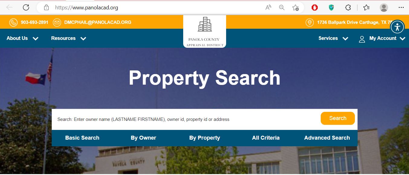
Enter an owner name, owner ID, Property ID or address for a broad first lookup.
Use owner ID, LASTNAME FIRSTNAME, care-of information or mailing-address fields.
Use Property ID, Geo ID, legal description, abstract, subdivision, lease name or lease number.
Combine owner, property, acreage, category, deed, value and protest-status fields.
Choose the Panola CAD search tab that matches the information you have
| Search option | Best information | Useful for | Common mistake |
|---|---|---|---|
| Basic Search | Owner name, owner ID, Property ID or address | A home, city lot or known account | Entering a complete deed description in one keyword box |
| By Owner | Owner ID, owner name, care-of or mailing address | Finding multiple accounts under one person, estate, trust or business | Ignoring a spouse, previous owner, company or estate name |
| By Property | Property ID, Geo ID, legal, abstract, subdivision or lease | Timber, agricultural, mineral, rural and industrial accounts | Relying on a street address that is not used by the account |
| All Criteria | A combination of property and owner details | Narrowing common names or several similar tracts | Adding too many filters and excluding the correct result |
| Advanced Search | Category, acreage, value, deed, prior owner or specialised criteria | Bulk research, comparable accounts or complex property types | Forgetting to select the correct appraisal year or property type |
Understand what each Panola CAD field tells you
| Field | What it identifies | What it does not prove | Best next action |
|---|---|---|---|
| Property or Parcel ID | The appraisal account used by Panola CAD. | That every deed, tax or mineral system uses the same number. | Save it for CAD, protest and Tax Office questions. |
| Geo ID | A geographic appraisal reference connected to the property. | A surveyed boundary or legal acreage. | Compare it with the map, deed and legal description. |
| Owner ID | An owner record used to connect accounts in the appraisal system. | That every connected account represents the same property interest. | Use it to locate additional real, mineral or personal-property accounts. |
| Owner name | The owner carried for appraisal administration. | Complete surface title, mineral title, lien priority or heirship. | Use County Clerk land records when ownership matters. |
| Legal description | The abstract, survey, tract, lot, block or subdivision reference shown. | That the abbreviated description is sufficient for a deed or survey. | Compare it with recorded documents and professional survey information. |
| Category code | How CAD classifies the property, such as residential, timber, agricultural, mineral, utility or business property. | That the classification or use is correct. | Document the actual use and request correction or protest when needed. |
| Market value | CAD’s market-value determination for the selected appraisal year. | A guaranteed sale price or final tax bill. | Compare sales, property condition and equal-appraisal evidence. |
| Ag or timber value | The productivity value applied to qualifying land. | That the land’s normal market value is the lower productivity amount. | Confirm qualifying acreage, use, class and application status. |
| Appraised value | Value after an applicable appraisal limitation or special appraisal. | The taxable value for every taxing jurisdiction. | Continue to the exemption and jurisdiction sections. |
| Taxable value | Value remaining after exemptions for a taxing entity. | The live tax balance, penalties or payment status. | Open the Panola County Tax Office record. |
Use the Panola CAD interactive map to confirm the correct tract
Fix common Panola CAD property-search problems
| Problem | Likely reason | Practical fix |
|---|---|---|
| Owner name returns no result | The record may use initials, spouse, estate, trust, company or previous owner. | Search LASTNAME only, owner ID, Property ID or legal description. |
| Address is not recognised | A county road, farm road or rural account may use a different format. | Use the main road name, Geo ID, abstract or legal description. |
| Timber tract is missing | The tract may be indexed by legal description, abstract or owner rather than address. | Select Real and search the Property ID, Geo ID, abstract or subdivision. |
| Mineral interest is missing | The search may still be set to Real or the account may use a lease, estate or agent name. | Select Mineral and search the lease, owner ID, legal description or Geo ID. |
| Business account is missing | The account may use the legal entity, DBA or Personal property type. | Select Personal and try the company, owner ID, Property ID or situs. |
| Recently purchased property shows the seller | The recorded deed may still be processing into the appraisal system. | Confirm County Clerk recording and save the instrument or file number. |
| Appraisal and tax values differ | The wrong year may be selected or the Tax Office may not yet reflect a CAD correction. | Match the year, Property ID and correction date before contacting the controlling office. |
| Online protest cannot find the property | The account may require an Online Account PIN or may not be eligible for the selected route. | Use the official Request PIN page and contact CAD before the deadline. |
Local search tips for Carthage, timberland and rural property
Search the address, then verify Carthage ISD, City of Carthage, homestead exemption and improvement details.
Confirm the city and Beckville ISD taxing lines and compare the legal description with the parcel map.
Check Gary ISD, rural road information, acreage and every separate improvement or tract.
Use subdivision, lot, legal description and map position. Do not rely on a recreational or mailing address alone.
Review D1T classification, qualifying acreage, timber type, market value, productivity value and use history.
Check agricultural category, stocking or production history, homesite acreage and non-qualifying portions.
Search Mineral by owner ID, legal description, lease name and lease number rather than street address.
Search the deceased owner, estate, spouse, trust and heirs, then compare probate and recorded land records.
Verify the property type, category, agent, situs and whether the account is appraised by the district’s contracted specialist.
Separate market value, productivity value and taxable value
Panola CAD’s opinion of ordinary market value as of January 1 for the selected appraisal year.
The value after an applicable appraisal limitation or qualifying agricultural or timber appraisal.
The amount remaining after exemptions for each county, city, school or special district.
Check the homestead cap and temporary circuit-breaker limitation
A qualifying residence homestead’s appraised value generally cannot increase by more than 10% per year, plus qualifying new improvements.
Qualifying non-homestead real property with a 2026 value of $5,320,000 or less may receive the temporary 20% appraisal limitation.
Agricultural and timber productivity appraisal is not the same as a homestead cap or non-homestead circuit breaker.
Review Panola County productivity appraisal tract by tract
Panola County’s timber and rural-land accounts require a different review from a city home. Qualified land is appraised according to its capacity to produce agricultural or timber products rather than ordinary market value.
Check whether the account shows qualified timber use, restricted-use timber or another land category.
Confirm that the correct acres receive productivity appraisal and that homesite or non-qualifying land is separated.
Prepare documentation of agricultural or timber production during the required historical period.
Keep management plans, harvest records, contracts, replanting records, photographs and timber-stand information.
Keep leases, livestock records, crop records, receipts, photographs, acreage maps and management documentation.
Confirm prior land qualification and prepare the required wildlife-management plan and annual evidence.
| Land type | 2026 state cap rate | What the rate means |
|---|---|---|
| Agricultural or open-space land | 10.00% | Used by appraisal districts in the statutory productivity-value calculation; it is not a local property-tax rate. |
| Timberland | 7.77% | Used in the timber productivity-value calculation; it does not represent the percentage charged on the tax bill. |
Search Panola County mineral property without using a normal address
Check the Panola CAD account before filing an exemption
Confirm ownership, principal-residence use, address and the year the exemption should begin.
Review the additional school exemption, school-tax ceiling and possible instalment options.
Prepare the required disability evidence and review possible tax-ceiling treatment.
Use the correct veteran or surviving-spouse form and include the required VA documentation.
Prepare land-use history, acreage, production, management and supporting maps or photographs.
Use the appropriate current form and attach property-use, inventory or organisational documents.
Prepare these items before applying
Search and prepare a Panola County business-property account
Read the Notice of Appraised Value before deciding what to file
Confirm owner, mailing address, Property ID, Geo ID, legal description and property type.
Compare prior and proposed market, appraised and productivity values.
Review acreage, classification, square footage, condition, use and listed structures.
Confirm homestead, age, disability, veteran and special-use benefits.
Use the exact date printed on the notice rather than relying only on a general May deadline.
Keep the PIN or request one through Panola CAD when the online filing system requires it.
Build a Panola CAD protest around one supported issue
Evidence checklist by property type
Comparable sales, condition photographs, repair estimates, measurements and closing documents.
Use history, acreage maps, timber plans, harvest records, leases, production and management evidence.
Lease information, ownership interest, production records, division orders and appraisal-method evidence.
Asset schedules, original costs, acquisition years, condition and disposal information.
Ownership, occupancy, identification, age, disability, veteran or qualification documents.
Survey, deed, measurements, photographs, permits or evidence showing the incorrect characteristic.
Present the Panola County protest as a short, organised case
Use the Panola County Tax Office search without creating an unnecessary account
Check every entity attached to the Panola County property
Panola CAD appraises property for the county, cities, school districts, Panola College, the groundwater district and the emergency-services district. The Tax Office portal lists the jurisdictions it collects.
Panola County and the county road or special tax line may appear separately.
City of Carthage, City of Beckville or the Panola County portion of City of Tatum may apply.
Beckville, Carthage, Gary, Elysian Fields, Joaquin, Tatum or Tenaha ISD may appear depending on location.
The college district can appear as a separate taxable jurisdiction.
Panola County ESD #1 may appear as a separate tax line.
The Panola County Groundwater Conservation District can appear on the property account.
Correct the Panola County office that controls the inaccurate field
Use Panola County Clerk records for deeds, liens and legal ownership research
Do not rely on one Panola CAD screen before a property decision
Match the Property ID, Geo ID, legal description, map location and acreage.
Review every tax year, payment, penalty and collection balance.
Use County Clerk records and obtain professional title work before closing.
The seller’s homestead exemption, appraisal cap or tax ceiling may not continue.
Confirm use history, qualifying acreage, future use and possible additional-tax exposure.
Determine whether minerals are included, reserved, severed or owned by another party.
Compare CAD square footage, age, condition, use and structures with the real property.
Check county, city, school, college, ESD and groundwater-district lines.
Keep the deed, title policy, survey, tax certificate, closing statement and exemption confirmation.
Use Panola CAD records when one property page is not enough
Available in geographic, alphabetical, PDF and spreadsheet formats for recent certified years.
Downloadable mineral appraisal-roll files support broader owner or lease research.
Useful when reviewing business personal-property appraisal assumptions.
Panola CAD publishes the current special-valuation capitalization rate.
Review hearing expectations, evidence procedures and board-process information.
Use these records for transparency, district operations and broader appraisal research.
Important Panola County dates to verify
Panola County appraisal, tax and land-record offices
Carthage, Texas 75633-3368
Phone: 903-693-2891
Fax: 903-693-8229
Email: dmcphail@panolacad.org
Chief Appraiser: Douglas McPhail
Hours: Monday-Thursday 8:00 AM-4:30 PM; Friday 8:00 AM-4:00 PM.
Tax portal: 110 S. Sycamore, Room 128
Carthage, Texas 75633
Phone: 903-693-0340
Fax: 903-693-2726
Email: holly.gibbs@co.panola.tx.us
Tax Assessor-Collector: Holly Gibbs
Tax portal hours: Monday-Friday 8:00 AM-5:00 PM.
Carthage, Texas 75633
Phone: 903-693-0302
Fax: 903-693-0328
Records email: countyclerk@co.panola.tx.us
County Clerk: Bobbie Davis
Use the Clerk for deeds, liens, plats and recorded land documents.
Bring the Property ID, Geo ID, owner, address, legal description, tax year and supporting documents.
Call ahead to confirm the room, department, public hours, identification and accepted payment method.
Official Panola County property resources
Search real estate, mineral and personal-property accounts.
Open official property searchReview parcel location and nearby appraisal-map context.
Open the interactive mapFind homestead, veteran, agricultural, timber, rendition and protest forms.
Open official formsCreate an account, sign in and manage an eligible appraisal protest.
Open Online ProtestRequest the unique Online Account PIN for the property.
Request a property PINAccess ARB rules, schedules, reports and certified appraisal-roll files.
Open Data and RecordsSearch current and delinquent tax accounts and open Tax Summary.
Open the tax portalUse the official county page to access Tyler Eagle land-record search.
Open Panola County ClerkCross-check the CAD, Tax Office and active taxing jurisdictions.
Open the state directoryHow this Panola County guide was improved

Independent research with property-type-specific instructions
This regenerated version preserves the useful Panola CAD search image already published on the page while replacing the brief article with complete property-search steps, field explanations, timber and agricultural guidance, mineral workflows, exemption preparation, protest evidence, tax-payment instructions, deed research and local office routing.
Official-source review included Panola County Appraisal District, Panola County Tax Assessor-Collector, Panola County Clerk and the Texas Comptroller’s current county, exemption, valuation and special-appraisal resources.
AppraisalDistrict.org is an independent informational website and is not operated by Panola County Appraisal District, Panola County or the Texas Comptroller.
10 common Panola County Appraisal District questions
1. What is the official Panola County Appraisal District website?
The official website is panolacad.org. Use it for property search, map search, exemptions, forms, protests, reports, certified rolls and appraisal-district contact information.
2. How do I search Panola County property records?
Open the official CAD search and choose Basic Search, By Owner, By Property, All Criteria or Advanced Search. Search by Property ID, Geo ID, owner ID, owner name, address, legal description, abstract, subdivision, lease name or lease number.
3. Can I search Panola County mineral property?
Yes. Select Mineral as the property type and use the Property ID, Geo ID, owner, owner ID, legal description, abstract, lease name or lease number.
4. Why does a Panola CAD address search show no result?
Timberland, rural acreage, mineral interests, pipelines and business accounts may not use a normal street address. Try the Property ID, Geo ID, legal description, abstract, subdivision, lease or owner information.
5. Does Panola CAD collect property-tax payments?
No. Panola CAD handles appraisal records, values, exemptions, maps and protests. Use the Panola County Tax Office portal for bills, balances, payments and receipts.
6. How do I pay Panola County property taxes online?
Search the property on the official Tax Office website, open the correct result and select Tax Summary. The Tax Office specifically instructs users not to create an account solely to make an online payment.
7. How do I check whether a homestead exemption is active?
Open the complete Panola CAD property account and review its exemption and taxing-jurisdiction sections for the correct year. Contact CAD with the Property ID and application proof if an expected exemption is missing.
8. What is the Panola CAD protest deadline?
Most protests are due by May 15 or within 30 days after the appraisal district mailed the Notice of Appraised Value, whichever is later. Follow the deadline printed on the individual notice.
9. Does the Panola CAD owner field prove legal ownership?
No. Use the Panola County Clerk land-record system and professional title research when legal ownership, liens or mineral title must be established.
10. Where is Panola County Appraisal District located?
Panola CAD is located at 1736 Ballpark Drive, Carthage, Texas 75633. Its phone number is 903-693-2891. Office hours are Monday-Thursday 8:00 AM-4:30 PM and Friday 8:00 AM-4:00 PM.