Jeff Davis County Appraisal District CAD And Tax Info 2026

Jeff Davis County, Texas · Homes, ranches, minerals, exemptions, protests, taxes and deeds

Navigate Jeff Davis County Property Records Across the Mountains and Open Range

Jeff Davis CAD separates real estate, mineral interests and personal property and offers detailed searches by owner, property ID, geographic ID, legal description, abstract, subdivision and lease information.

Use the appraisal district for values, exemptions, agricultural valuation, maps and protests. Use the County Tax Assessor-Collector for tax statements and payments, and the County Clerk for deeds, liens and recorded land documents.

Property ID Owner or geographic ID Legal description Abstract or subdivision Lease name or number
DAVIS MOUNTAINS PROPERTY ROUTER LOCATING ACCOUNT
SEARCH → VERIFY → SAVE → ACT
Do not treat every Jeff Davis County account like a Fort Davis home. Large ranch tracts, remote acreage, mineral interests, utility property, industrial accounts and business assets may require a property ID, geographic ID, abstract, legal description or lease detail instead of a normal street address.
Three property types

Real Estate, Mineral Property and Personal Property.

CAD office

100 Court Avenue, Fort Davis, Texas.

CAD hours

9:00 AM-noon and 1:00 PM-5:00 PM, Monday-Friday.

Tax office

105 Court Avenue, Fort Davis.

Official review

Local links and procedures reviewed July 2026.

Start with the task

Which Jeff Davis County property service do you need?

FIND PROPERTY Search the appraisal account

Use owner, property ID, geographic ID, address, legal description, abstract or subdivision.

Follow the official search steps
RANCH OR OPEN SPACE Review agricultural valuation

Confirm qualifying use, acreage, production value, market value and possible rollback exposure.

Prepare agricultural evidence
MINERAL INTEREST Use the mineral-property search

Search by owner, property ID, lease name, lease number or legal information rather than address alone.

Search mineral records
PROTEST VALUE Use online protest or written filing

Request the account PIN early, save the notice and build evidence around one clear appraisal issue.

Prepare the protest file
PAY PROPERTY TAX Use the County Tax Office route

Start from the county website, confirm the tax year and save the payment receipt.

Follow the payment workflow
DEED OR LIEN Use County Clerk records

Search older Kofile records online and contact the Clerk for newer or unavailable documents.

Search land records

Go directly to the Jeff Davis County task

Use the first sections for appraisal lookup. Later sections cover ranch land, minerals, protest, payment, deeds and local office routing.

Image retained from the original article

Use the existing search screenshot to choose the correct route
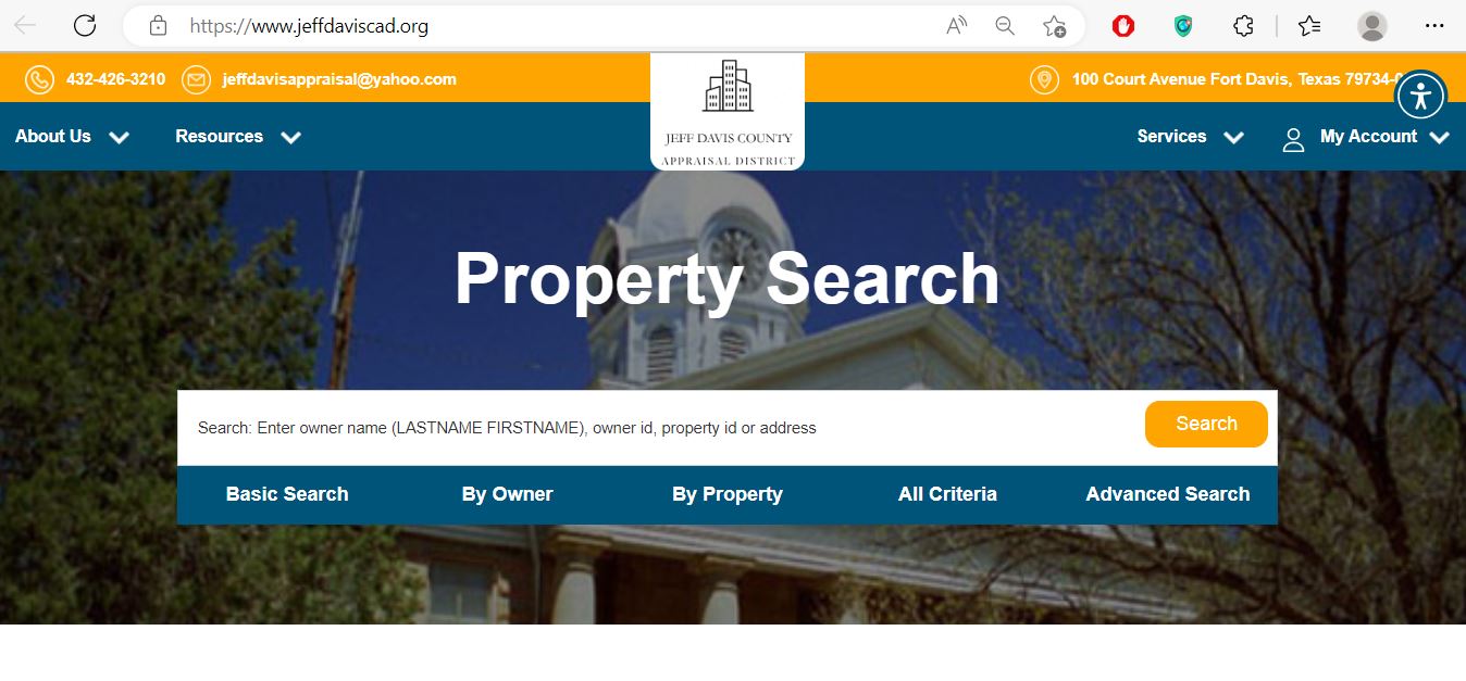
Jeff Davis County Appraisal District property search showing basic, owner, property, all criteria and advanced search tabs
This screenshot appeared in the existing article and has been preserved. The official interface may change, but the five search paths remain useful: Basic Search, By Owner, By Property, All Criteria and Advanced Search.
Basic Search

Use a surname, owner ID, property ID or a short address.

By Property

Use property ID, geographic ID, legal description, abstract, subdivision or lease details.

Advanced Search

Combine property and owner criteria only after a simpler search produces too many results.

Advanced search controls

Use Jeff Davis CAD’s detailed fields for ranches, minerals and difficult addresses

Official Jeff Davis CAD search · start with one strong identifier

Available search fields

Property ID · Geographic ID · Owner ID
Owner name · Care of · Mailing street · City
Street number · Direction · Street · City · ZIP
Legal description · Abstract · Subdivision
Lease name · Lease number · Property ID
Search and verify
Tax year: match the notice or bill
Property type: real, mineral or personal
Property ID: save for office contact
Geographic ID: compare with map context
Legal or lease: match the correct tract or interest
Exemptions: confirm the selected year
Local appraisal arrangement: Jeff Davis CAD states that mineral, utility and industrial accounts are appraised for the district by Thomas Y. Pickett. Real-estate and personal-property accounts are appraised locally by the district.
Account-field decoder

Understand what a Jeff Davis CAD record can and cannot prove

Use each field as a route to the next verification step
Field What it identifies What it does not prove Next action
Property ID The appraisal account in Jeff Davis CAD. That every county or payment system uses the same number. Save it for CAD, protest and tax questions.
Geographic ID A geographic or parcel-related account reference. A surveyed boundary or legal acreage. Compare the map, deed and survey.
Owner shown The owner carried for appraisal and notice purposes. Complete deed, probate, lien or mineral-title history. Research County Clerk records when title matters.
Situs address The physical location used in the appraisal system. Legal access, mailing address or boundary location. Compare the legal description and map.
Legal description An abbreviated tract, abstract, subdivision, lot or block reference. The complete deed description. Read the recorded deed and survey.
Lease name or number A mineral or industrial account connection. Legal mineral ownership or royalty entitlement. Review recorded leases, assignments and probate records.
Market value The appraisal district’s opinion of value for the selected year. A guaranteed sale price or the final tax balance. Review account facts and value evidence.
Production value A special agricultural valuation when qualification is approved. That the land can change use without additional tax consequences. Review qualifying use and rollback exposure.
Taxable value Value remaining after exemptions for a taxing unit. The live amount due or payment status. Confirm the bill with the Tax Office.
Map and parcel context

Use the Jeff Davis CAD interactive map for remote property research

Open the official interactive map Open Jeff Davis CAD Interactive Map
Find the appraisal account first Save the property ID, geographic ID, owner, legal description and acreage before using the map.
Locate roads and adjoining parcels Map context is especially useful for remote ranches, access roads, mountain tracts and properties without dependable street addresses.
Compare nearby appraisal accounts carefully Check acreage, land use, improvements, access and special valuation before treating another account as comparable.
Verify legal questions outside the map Use the deed, plat, easements, title documents and a professional survey for boundary or access decisions.
A CAD parcel line is not a fence line or title opinion. Do not build, fence, buy or resolve an access dispute from the appraisal map alone.
Search troubleshooting

What to do when a Jeff Davis County property does not appear

Change the search method before assuming the account is absent
Problem Likely reason Practical fix
Owner search returns nothing The account may use a trust, estate, spouse, company or abbreviated name. Search only the surname or one distinctive entity word.
Address search fails The parcel may be rural, remote or indexed by legal description. Use property ID, geographic ID, abstract, subdivision or map.
Ranch land is missing A normal street address may not exist or may not match the appraisal record. Search by owner, legal description, abstract or geographic ID.
Mineral account is missing The search is limited to Real Estate. Select Mineral Property and search owner, lease or property ID.
Business assets are missing The account may be classified as Personal Property. Select Personal Property and search the owner or business name.
Recently purchased property shows seller The deed may still be processing into the appraisal system. Confirm recording with the County Clerk and save the document details.
Account disappears with tax-due filter The account may not show a current amount due. Turn off “Show only Properties with Tax Due.”
Acreage or map shape looks wrong The appraisal display may not reflect a newer deed, survey, split or combination. Gather deed, plat and survey evidence before contacting CAD.
Jeff Davis CAD call script
I am reviewing tax year [year] for property ID [number] or geographic ID [number]. I searched under [Real Estate, Mineral Property or Personal Property]. The record shows [owner, legal description, acreage, value or exemption], but I need help verifying or correcting [specific field]. Which document should I provide?
Value explanation

Separate market value, special valuation and taxable value

STEP 1 Market value

The district’s opinion of value as of January 1 for the selected tax year.

STEP 2 Appraised or production value

The value after an applicable appraisal limitation or approved agricultural valuation.

STEP 3 Taxable value

The value remaining after exemptions for the applicable taxing unit.

Market value is not the tax bill. The bill depends on taxable value, adopted tax rates, exemptions, special valuation, payment history, penalties and interest.
Jeff Davis County currently has three active taxing units listed in the Texas Comptroller directory: Jeff Davis County, Fort Davis Independent School District and Valentine Independent School District.
Office routing

Use the appraisal district, Tax Office or County Clerk correctly

Contact the office that controls the disputed record
Your question Correct office What to prepare
What is my appraised value? Jeff Davis CAD Property ID, tax year and disputed value.
Why is an exemption missing? Jeff Davis CAD Application, identification, qualification date and filing proof.
Does my ranch qualify for agricultural valuation? Jeff Davis CAD Use history, acreage, livestock or production records and maps.
How much property tax is due? Jeff Davis County Tax Assessor-Collector Owner, account, tax year and payment date.
Did my online payment post? County Tax Office Receipt, confirmation, amount and tax year.
Who legally owns the property? County Clerk or title professional Grantor, grantee, legal description and date range.
Who owns a mineral interest? County Clerk records and qualified mineral-title professional Deeds, reservations, leases, assignments and probate documents.
Who adopts the tax rate? Each taxing unit The taxing-unit list from the property account.
The Tax Assessor-Collector does not determine property value or tax rates. Jeff Davis CAD determines appraisal values, while the governing bodies of the taxing units adopt their tax rates.
Forms and exemptions

Use official Jeff Davis CAD forms and prepare the required proof

Residence homestead

For an owner-occupied principal residence. Match the ownership, residence address and identification before filing.

Age, disability or veteran

Use the matching form and attach the required age, disability or VA documentation.

Open-space agricultural use

Prepare land-use history, acreage, production evidence, maps, leases and supporting records.

Business rendition

Prepare asset descriptions, costs, acquisition dates, inventory and business-location information.

Timber and goods exemptions

The district’s forms page includes timber, exported-goods, goods-in-transit and tax-abatement applications.

Electronic delivery

Use the official electronic-delivery form when choosing eligible electronic communication with a tax official.

Mailing address: completed forms may be mailed to Jeff Davis County Appraisal District, P.O. Box 373, Fort Davis, Texas 79734.
Homestead identification: Jeff Davis CAD states that all homestead applications must include a copy of the applicant’s driver licence.
Ranch, agricultural and wildlife land

Prepare Jeff Davis County agricultural evidence around actual land use

Local filing period: Jeff Davis CAD states that owners may apply for agricultural valuation between January 1 and April 30 for the year in which the valuation is requested.
Acreage is not the only test

The district states that minimum acreage can vary because soil, forage, location and agricultural use differ across the county.

Livestock requirements vary

The number of animals needed depends on location, forage and animal type. Use the local agricultural policies rather than a statewide guess.

Production values differ by use

Native pasture, dry cropland and other qualifying uses can produce different productivity values.

Wildlife valuation

The property must already be under agricultural valuation, and the owner must timely file a new 1-D-1 application with a five-year wildlife-management plan.

Rollback exposure

A change from qualifying agricultural use can create additional tax. Review the planned change before developing or subdividing land.

Homestead exception

The district FAQ describes a statutory exception for a qualifying personal homestead of up to 20 acres. Confirm the exact facts before relying on it.

Agricultural evidence checklist

Property ID and legal description
Acreage map and land-use areas
Livestock numbers and grazing records
Crop, hay or production records
Leases, receipts and sales records
Dated photographs
Prior agricultural applications
Wildlife plan and annual evidence
Mineral, utility and industrial property

Search Jeff Davis mineral accounts without depending on a street address

Select Mineral Property A mineral interest will not necessarily appear in a Real Estate search.
Search the owner or property ID Use the owner carried on a notice, statement, royalty document or prior appraisal record.
Try the lease name and lease number These fields can identify an account that has no normal physical address.
Confirm the tax year and account type Ownership and valuation information can change between years.
Separate appraisal from legal title The CAD record supports valuation research but does not replace recorded mineral deeds, reservations, assignments or probate records.
Prepare identifiers before contacting the district Keep the property ID, owner, lease, legal details and disputed value together.
A mineral appraisal account is not a mineral-title opinion. Use recorded documents and a qualified land, title or legal professional when determining ownership or royalty rights.
Business personal property

Review business assets using the district’s 2026 depreciation schedule

Select Personal Property Business equipment and inventory may not appear under the real-estate account for the business location.
Search the owner or business name Try the legal entity, owner surname or one distinctive business word.
Confirm the business location Check that the assets are connected to the correct Jeff Davis County situs.
Compare the rendition and account Review asset type, acquisition date, original cost, age, condition and disposition.
Use the current depreciation schedule Jeff Davis CAD publishes a 2026 business-personal-property depreciation schedule in its Data and Records section.
Keep filing proof Preserve the rendition, extension request, supporting documents and delivery confirmation.
Online protest and ARB hearing

Request your account PIN early and build a focused protest

Normal filing rule: most protests are due by May 15 or the 30th day after the Notice of Appraised Value was delivered, whichever is later. The property-specific deadline on the notice controls.
Save the complete property account Keep the tax year, property type, owner, identifiers, legal or lease information, acreage, values and exemptions.
Read the Notice of Appraised Value Confirm the proposed value, notice date, filing deadline, online instructions and property facts.
Request the online account PIN when needed Jeff Davis CAD assigns a unique online PIN to each property. Create or sign in to an account and submit the requested property information. Request a Jeff Davis CAD PIN
File online or in writing The online-protest service requires account registration and sign-in. A paper Notice of Protest form is also available. Open Jeff Davis CAD Online Protest
Identify one clear protest issue Examples include market value, unequal appraisal, incorrect property characteristics, exemption denial, agricultural denial or business-property error.
Keep proof of timely filing Save the online confirmation, email, certified-mail receipt or stamped copy.
Collect evidence that matches the issue Use comparable sales, equal-appraisal examples, repair estimates, photographs, surveys, land-use records, leases or business documents.
Check the protest-hearing search The official search can locate 2026 open, future and past hearings by owner, address, owner ID, parcel ID, protest number, agent or hearing date. Search protest hearings
Prepare for the Appraisal Review Board Follow the 2026 ARB rules and procedures published in the Data and Records section.

Evidence packet

Notice of Appraised Value
Saved CAD account
One-page requested correction
Comparable or equal-appraisal table
Dated photographs
Repair estimates or reports
Deed, survey, lease or land-use evidence
Proof of timely filing
Tax bills, payments and receipts

Pay Jeff Davis County property taxes through the official county route

Jeff Davis CAD determines appraisal values and exemptions. The Jeff Davis County Tax Assessor-Collector handles property-tax statements, payment questions and collection.

Open the official Jeff Davis County website Open Jeff Davis County
Select “Online Payments for Property Tax” Use the payment link published by the county rather than a sponsored result or copied payment address.
Search or enter the requested account information Use the owner, account or tax-statement details requested by the secure payment processor.
Match the property and tax year Confirm the owner, account, property description, year and amount before continuing.
Review penalties and processing fees The displayed tax balance may not include every payment-processing charge.
Submit payment only after verification Recheck the account and year before authorising the transaction.
Save the confirmation Keep the receipt, confirmation number, tax year, account, amount, fee and payment date.
Verify that the payment posted Contact the Tax Office when a payment does not appear or a receipt is needed.
Payment safety: begin at the official Jeff Davis County website. Do not enter bank or card information through an unsolicited email, text message, advertisement or copied payment page.
Tax-payment contact: Jeff Davis County Tax Assessor-Collector, 105 Court Avenue, Fort Davis; phone 432-426-3962.
Deeds, liens and historic land records

Use the County Clerk’s Kofile system for older Jeff Davis County records

Online coverage: the Jeff Davis County Kofile QuickLink provides index books and land records from 1879 through 1997, including deeds, deeds of trust and official public records volumes 1 through 224.
Open the official County Clerk page Open Jeff Davis County Clerk
Select Kofile QuickLinks The Clerk links directly to the county’s historical online land-record system. Open Jeff Davis County QuickLink
Search index books by record type and name Available index categories include deeds, deeds of trust, mortgages and surveyor field notes.
Use volume and page when known The document search includes deed records, deeds of trust, lease records, lis pendens, mechanics liens, official public records and other record books.
Register before purchasing pages Kofile states that land-record images cost $1 per page plus a $0.25 processing fee for each purchased page.
Contact the Clerk for newer or unavailable records The online QuickLink coverage ends in 1997. Call or visit the Clerk for later documents and records not available in the portal.
Use a title professional for complete research A portal search does not guarantee clear title or identify every easement, restriction, probate issue or mineral reservation.
The County Clerk also links a current “Recording Requirements for Official Public Records” document. Review it or call the office before mailing or presenting a document for recording.
Buyer, owner and heir checks

Complete these checks before relying on one Jeff Davis County record

Match the property

Compare property ID, geographic ID, legal description, acreage and map location.

Check all account types

Search real estate, mineral property and personal property when the transaction involves more than land.

Review tax status

Confirm every tax year, amount due, payment posting, penalty and receipt with the Tax Office.

Search deed history

Review deeds, deeds of trust, liens, easements, probate records and releases.

Check mineral reservations

A surface-property transfer does not automatically include every mineral interest.

Recalculate exemptions

Seller homestead benefits, tax ceilings and appraisal limitations may not continue after transfer.

Review agricultural status

Determine whether qualifying use will continue and whether a change could create rollback tax.

Verify access and boundaries

Use recorded easements, title documents and a professional survey rather than the CAD map alone.

Keep transaction records

Save the deed, title policy, survey, closing statement, tax receipt and exemption confirmation.

The seller’s current tax bill may not predict the buyer’s future bill. Homestead exemptions, appraisal caps, special valuation, ownership changes and land-use changes can alter future taxable value.
2026 action calendar

Important Jeff Davis County appraisal and tax dates

Appraisal and qualification date Ownership, condition, use and qualification for many exemptions are generally determined as of January 1.
Local agricultural filing period Jeff Davis CAD states that agricultural-valuation applications may be filed from January 1 through April 30.
Normal rendition deadline Most business-personal-property renditions are due April 15, subject to extension rules.
Common exemption and special-valuation date Many exemption and agricultural applications use April 30 as the normal filing date.
Normal protest deadline File by May 15 or the 30th day after the appraisal notice was delivered, whichever is later.
Informal review and ARB hearings Check the official hearing search and follow the evidence instructions for the property.
Tax-rate process Jeff Davis County and the school districts propose and adopt rates, and tax-transparency information is updated.
Tax statements generally begin Confirm the property, account, tax year and amount with the County Tax Office.
Normal payment deadline Property taxes are generally payable without penalty through January 31, subject to weekend, holiday and late-bill rules.
The date printed on the notice, bill, hearing letter or application controls. Use this calendar for preparation rather than as a replacement for a property-specific deadline.
Verified local contacts

Jeff Davis County appraisal, tax and land-record offices

Jeff Davis County Appraisal District
100 Court Avenue
Fort Davis, Texas 79734
Mailing: P.O. Box 373, Fort Davis, Texas 79734-0373

Phone: 432-426-3210
Fax: 432-426-3437
Email: jeffdavisappraisal@yahoo.com

Hours: Monday-Friday, 9:00 AM-noon and 1:00 PM-5:00 PM.

Chief Appraiser: Gary Zeitler

Jeff Davis County Tax Assessor-Collector
105 Court Avenue
Fort Davis, Texas 79734
Mailing: P.O. Box 1061, Fort Davis, Texas 79734-1061

Phone: 432-426-3962
Fax: 432-426-0801
Email: 122taxoffice@jeffdaviscounty.texas.gov

Tax Assessor-Collector: Sheriff Victor Lopez

Jeff Davis County Clerk
111 North Front Street
Fort Davis, Texas 79734
Mailing: P.O. Box 398, Fort Davis, Texas 79734

Phone: 432-426-3251
Fax: 432-426-3760

County and District Clerk: Jennifer Wright

Call to confirm hours and recording requirements before travelling.

Active taxing units

Jeff Davis County, Fort Davis Independent School District and Valentine Independent School District are the active units listed in the Comptroller’s county directory.

Call before making a long trip. Confirm holiday closures, office lunch hours, required identification, filing methods and whether the task belongs to CAD, the Tax Office or the Clerk.
Official action resources

Jeff Davis County appraisal, tax and land-record links

Property search

Search real estate, minerals and personal-property accounts.

Open official CAD search
Interactive map

Research remote tracts, roads and nearby appraisal accounts.

Open interactive map
Forms

Find homestead, agricultural, rendition, protest and special-use forms.

Open official forms
Online protest

Register or sign in to file an eligible protest.

Open online protest
Request a PIN

Request the property-specific online account PIN.

Request online PIN
Protest hearings

Search open, future and past 2026 protest hearings.

Search hearings
Data and reports

Review ARB rules, appraisal rolls, agricultural policies and depreciation schedules.

Open records and reports
Property-tax payment

Use the county-published Online Payments for Property Tax link.

Open county payment route
Historic land records

Search deeds and related land records from 1879 through 1997.

Open Kofile QuickLink
Editorial accountability

How this Jeff Davis County guide was rebuilt

Mahesh Kumar, editor of AppraisalDistrict.org

Independent research with official-source task guidance

This improved article preserves the property-search screenshot and editor image used by the previous page while replacing its shorter guidance with property-type routing, advanced search fields, rural-land help, agricultural rules, mineral guidance, protest preparation, payment safety and historic deed-record instructions.

The review used Jeff Davis County Appraisal District, the Jeff Davis County Tax Assessor-Collector, Jeff Davis County Clerk, Kofile QuickLink and the Texas Comptroller county directory.

AppraisalDistrict.org is an independent informational website and is not operated by Jeff Davis CAD, Jeff Davis County or any taxing unit.

Jeff Davis County answers

10 common Jeff Davis County Appraisal District questions

1. What is the official Jeff Davis County Appraisal District website?

The official website is jeffdaviscad.org. Use it for property search, forms, maps, online protest, account registration and appraisal records.

2. How do I search Jeff Davis County property records?

Search by owner, owner ID, property ID or address. More detailed routes include geographic ID, legal description, abstract, subdivision, lease name and lease number.

3. What property types can I search?

The official search separates Real Estate, Mineral Property and Personal Property accounts. Change the property type when a valid account does not appear.

4. Who appraises mineral and industrial accounts?

Jeff Davis CAD states that mineral, utility and industrial accounts are appraised by Thomas Y. Pickett. Real-estate and personal-property accounts are appraised locally.

5. Who collects Jeff Davis County property taxes?

The Jeff Davis County Tax Assessor-Collector handles property-tax statements and payments. Call 432-426-3962 for payment questions.

6. How do I pay property taxes online?

Open the official county website and select “Online Payments for Property Tax.” Match the property and tax year, review the fee and save the confirmation.

7. What is the normal protest deadline?

The normal deadline is May 15 or the 30th day after the Notice of Appraised Value was delivered, whichever is later. Follow the exact date printed on the notice.

8. When do I apply for agricultural valuation?

Jeff Davis CAD states that applications may be filed between January 1 and April 30 for the year in which agricultural valuation is requested.

9. Where can I search older Jeff Davis County deeds?

Use the County Clerk’s Kofile QuickLink for land records covering 1879 through 1997. Contact the Clerk for later records.

10. Is the CAD map a legal survey?

No. Use the map for appraisal research only. Use recorded documents, title research and a professional survey for legal boundaries or access.

Leave a Comment