Follow a Dawson County Property From Search Result to Value, Tax Due and Recorded Ownership
Dawson County works differently from many Texas counties. Dawson County Central Appraisal District does more than appraise property: it also states that it collects taxes for several participating local entities.
Use the same official database to find real estate, personal property and mineral accounts, review appraisal information, identify base tax due, file a protest and reach the district’s collection staff. Use the County Clerk when the task involves legal ownership, deeds, liens or recorded documents.
Dawson CAD handles appraisal and participating-entity property-tax collection.
1806 Lubbock Highway, Lamesa, Texas 79331.
Monday-Friday, 8:30 AM-5:00 PM.
The search supports lease name, lease number and mineral-property filters.
Official resources and contacts reviewed July 2026.
What do you need from the Dawson County property account?
Use owner name, owner ID, property ID or address, then confirm the legal description and property type.
Follow the search workflowCompare land, improvements, market value, appraised value, taxable value and exemptions.
Understand the value fieldsFilter properties with tax due, open the correct account and verify the participating entities and current payoff.
Use the payment checklistIdentify the exact value, exemption, property-detail, acreage or classification issue.
Build the protest fileRecorded deeds, liens and releases control legal-document history—not the appraisal owner field alone.
Follow the deed-record routeSurface land, mineral interests, business assets and improvements may appear in different records.
Review mineral and lease fieldsSearch Dawson CAD without opening the wrong real, personal or mineral account
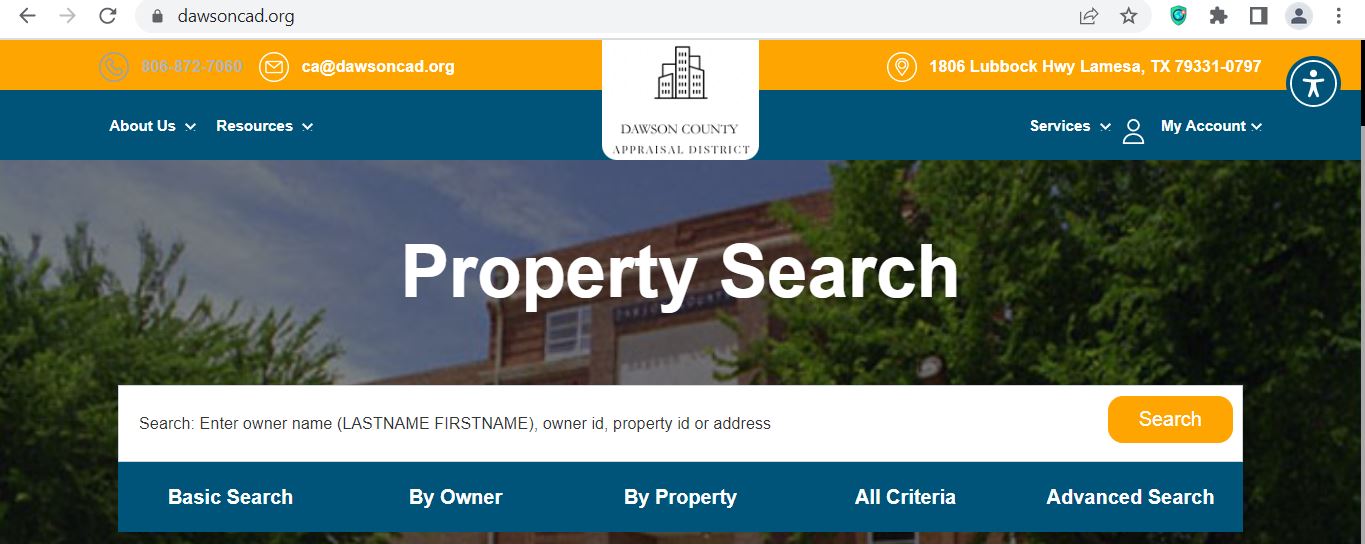
Use the Dawson CAD screenshot to recognise the search controls
The original article included the official Dawson CAD search screenshot below. It is preserved and placed inside the exact workflow where it helps. The live interface may change, so reopen the official site before relying on a property result.
Choose the Dawson CAD filter that matches the property
| Search field | Use it when | What to verify |
|---|---|---|
| Owner name | You know the homeowner, company, estate, trust or mineral owner. | Name order, spelling, property type and legal description. |
| Owner ID | You have an owner identifier from an existing Dawson CAD record. | Each separate parcel or interest connected to that owner. |
| Property ID | You copied the number from a notice, statement or prior account. | Tax year, account type and owner. |
| Geographic ID | You are matching the account to a map, abstract, survey or legal description. | Recorded documents and surveyed boundaries. |
| Legal description | The parcel lacks a reliable street address or involves rural acreage. | Section, block, survey, tract, lot, block and acreage. |
| Abstract | You are searching rural land or an older survey-based description. | The complete abstract or survey reference. |
| Subdivision | You know the addition, subdivision, lot or block. | Phase, lot, block and property ID. |
| Lease name or number | You are researching a mineral, royalty or oil-and-gas-related account. | RRC number, interest type, decimal interest and legal description. |
| Protest status | You need to locate accounts connected to an appraisal protest. | Tax year, hearing status and official notice. |
| Land acres or value range | You are building a comparison group for land or equal-appraisal research. | Property class, location, use, improvements and agricultural status. |
| Show only properties with tax due | You are locating unpaid participating-entity taxes. | Tax year, taxing entities, penalties and current payoff. |
Understand what each Dawson CAD field tells you
| Field | What it identifies | What it does not prove | Next action |
|---|---|---|---|
| Property or parcel ID | The appraisal account in Dawson CAD’s system. | That the County Clerk uses the same number. | Save it for appraisal, protest and collection questions. |
| Owner shown | The owner carried for appraisal and tax administration. | Complete legal or mineral title. | Search recorded County Clerk documents. |
| Property address | The situs or physical location carried in the account. | The mailing address or complete legal description. | Compare the map, legal description and deed. |
| Legal description | A lot, block, tract, subdivision, abstract, section or survey reference. | A deed-ready legal description. | Open the recorded deed or plat. |
| Acreage | The acreage carried for appraisal purposes. | Surveyed or legally guaranteed acreage. | Use a professional survey for boundary decisions. |
| Market value | CAD’s opinion of market value as of January 1. | A guaranteed sale price or final tax due. | Compare sales, condition and equal-appraisal evidence. |
| Appraised value | Value after an applicable appraisal limitation. | The value after every exemption. | Review taxable value for each taxing entity. |
| Taxable value | The value remaining after applicable exemptions. | The current payoff or payment status. | Review the tax ledger and base tax due. |
| Base tax due | A collection amount shown in Dawson CAD’s search results. | The final payoff including every penalty, fee or later payment. | Open the account and confirm the current amount with collections. |
| Lease and mineral information | Lease number, lease name, RRC number, interest type or decimal interest associated with an appraisal account. | Complete mineral ownership or the correctness of a royalty division order. | Review recorded instruments and Railroad Commission records. |
Use the Dawson CAD map without treating its parcel lines as a survey
Separate market value, appraised value and taxable value
Dawson CAD’s opinion of the property’s market value as of January 1 for that tax year.
The value after an applicable residence-homestead or non-homestead appraisal limitation.
The value remaining after exemptions. It can differ for the county, city, school, hospital and water district.
Use Dawson CAD’s certified rolls when a searchable account is not enough
Dawson CAD’s Data and Records page provides downloadable appraisal rolls, tax-rate information, capitalization rates, utility reports, shapefile resources and Truth-in-Taxation worksheets.
The district currently lists 2026 certified real and personal appraisal rolls in geographic, alphabetical and spreadsheet formats.
Mineral roll downloads are listed separately for available years because mineral accounts differ from normal real-property records.
Use certified rolls for account reconciliation, ownership review, appraisal research or large comparison projects.
GIS users can review the available shapefile date before relying on parcel geography.
Income-producing-property researchers can review the district’s published capitalization-rate resources.
Review taxing-unit calculations separately from the appraisal value shown in the property account.
Fix common Dawson CAD search problems before calling
| Problem | Likely reason | Practical fix |
|---|---|---|
| Owner name returns nothing | Different name order, initials, spouse, estate, trust, company or previous owner. | Search only the last name, then try Owner ID or property ID. |
| Too many owner matches | The name is common or appears on multiple real, mineral or personal-property accounts. | Add property type, street, geographic ID, abstract or subdivision. |
| Full address fails | The account may use a different suffix, rural description, direction or city. | Search only the street name, then add the number. |
| Rural tract lacks an address | The property may be indexed by abstract, section, survey or legal description. | Use By Property, All Criteria or the interactive map. |
| Mineral account is missing | The interest may use a lease name, lease number, mineral owner or separate property type. | Use lease and mineral fields and search all owner variations. |
| Recently purchased property shows seller | The recorded deed may still be processing into the appraisal account. | Confirm recording with the County Clerk and save the instrument number. |
| Tax due does not appear | The wrong year, property type or collecting entity may be selected. | Select Show Only Properties with Tax Due and confirm the entity collector. |
| Payment and account do not match | Payment may have been applied to another year, parcel, sequence or account. | Contact Dawson CAD collections with the receipt and property ID. |
| Online protest is unavailable | The user may not be signed in, the PIN may be missing or the filing period may be closed. | Register, request the PIN and use a written protest if necessary to protect a deadline. |
Local search tips for Lamesa homes, rural acreage, cotton land and mineral interests
Check City of Lamesa, Lamesa ISD, Dawson County, hospital and water-district taxable values separately.
Confirm the county and school or city boundaries because the mailing city may not identify every taxing unit or collector.
Verify the school-district account and whether maintenance-and-operations and debt-service lines appear separately.
Search by owner, property ID, geographic ID, abstract, section, survey or legal description.
Review market value, productivity value, qualifying acreage, improvements and current special-appraisal status.
Check land class, water availability, well or irrigation improvements and Mesa Underground Water District.
Search mineral-property filters, lease name, lease number, RRC number, interest type and decimal interest.
Search the legal business, DBA and personal-property account separately from the land or building.
Determine whether the home and land are assessed together or through separate real- and personal-property records.
Send each Dawson County property question to the office that controls it
| Your question | Correct starting point | What to prepare |
|---|---|---|
| What is the appraised value? | Dawson County Central Appraisal District | Property ID, tax year and disputed value field. |
| Why is an exemption missing? | Dawson County Central Appraisal District | Application, ID, qualification date and filing proof. |
| What taxes are due for participating entities? | Dawson CAD collections | Property ID, account, tax year and proposed payment date. |
| Did my property-tax payment post? | Dawson CAD collections | Receipt, confirmation, amount, date and tax year. |
| Does the County Tax Assessor collect property tax? | No—confirm through Dawson CAD | The individual property account and taxing-unit list. |
| Who legally owns the property? | Dawson County Clerk or title professional | Grantor, grantee, instrument number and legal description. |
| Where can I obtain a deed, lien or release? | Dawson County Clerk | Names, date range, document type and recording reference. |
| Who appraises mineral, utility or industrial accounts? | Dawson CAD, with Pritchard & Abbott appraisal services | Property ID, lease, owner, RRC number and disputed field. |
| Who sets tax rates? | Each local taxing unit | The taxing-unit list from the property account. |
| Who handles vehicle registration or voter registration? | Dawson County Tax Assessor-Collector | The documents required for that non-property-tax service. |
Correct the source of the inaccurate Dawson County information
Verify Dawson County exemptions before estimating the tax bill
An exemption can reduce taxable value without reducing market value. Review the exemption and taxable value for every participating taxing entity.
Confirm ownership, principal-residence use, identification and the exemption shown on the current account.
Review the additional exemption, school-tax ceiling and available instalment, deferral or collection options.
Check eligibility documentation, the additional exemption and any applicable school-tax ceiling.
Use the correct veteran category and attach the required Department of Veterans Affairs documentation.
Prepare occupancy, ownership, heirship and family-history documents when record ownership is incomplete.
Use the district or Comptroller forms for charitable, religious, cemetery, solar and other qualifying property.
What to prepare before filing
Prepare land-use evidence instead of relying on acreage alone
Keep planting, input, harvest, gin, sale, lease and production records tied to the property.
Document stocking, fencing, water, grazing leases, animal records and normal management practices.
Identify irrigation improvements, water source, productive acres and actual agricultural use.
Confirm prior open-space qualification and preserve the wildlife plan, practices, maps and annual evidence.
Explain temporary conditions, crop rotation, drought, conservation programs or changes in agricultural use.
Ask about additional-tax consequences before development, subdivision or conversion to nonagricultural use.
Application evidence checklist
Trace Dawson County mineral interests through the correct records
Dawson CAD states that mineral, utility and industrial accounts are appraised for the district by Pritchard & Abbott. The official property database includes fields that are especially useful for mineral research.
| Field or source | What it helps identify | Important limitation |
|---|---|---|
| Mineral property type | Separates a mineral appraisal account from surface real property. | It does not prove complete ownership of the mineral estate. |
| Lease name and number | Helps locate appraisal records connected to a producing lease. | A lease name can differ from the legal owner or operator name. |
| RRC number | Helps match the appraisal account to Railroad Commission records. | It does not determine mineral title. |
| Interest type | May identify a royalty, overriding royalty or other appraised interest. | Confirm the meaning through deeds, leases and division orders. |
| Decimal interest | Shows the decimal used in the appraisal account. | It should not replace a professional ownership or royalty calculation. |
| County Clerk records | Shows recorded mineral deeds, reservations, leases, assignments and releases. | A complete chain may require extensive historical research. |
| Railroad Commission records | Shows regulated wells, leases, operators and related energy information. | The RRC does not determine private mineral ownership. |
Keep business assets separate from the real-property account
Equipment, machinery, furniture, fixtures, vehicles, inventory and other income-producing personal property can have a separate Dawson CAD account and rendition requirement.
Build a Dawson CAD protest around one clear issue
Evidence checklist
Verify the Dawson County protest hearing before travelling
Dawson CAD provides a public Protest Hearing Search that can filter past hearings, future hearings and open protests.
Use Dawson CAD—not the County Tax Assessor—to verify participating-entity property taxes
| Task | Correct office or route | Practical check |
|---|---|---|
| Search participating-entity taxes | Dawson CAD property search | Select the year and Show Only Properties with Tax Due. |
| Credit-card payment | Dawson CAD collection staff or account payment option | Confirm processing fee and final total. |
| Payment agreement | Dawson CAD collections | Ask about eligibility, terms, penalties and required documents. |
| Mortgage or escrow issue | Dawson CAD mortgage and collections staff | Prepare lender, escrow and property-account information. |
| Delinquent payoff | Dawson CAD collections | Request the amount through the intended payment date. |
| Vehicle registration | Dawson County Tax Assessor-Collector | Do not use this office for the property-tax payment. |
Use the Dawson County Clerk for deeds, liens, releases and plats
Complete these checks before relying on a Dawson County property record
Match property ID, geographic ID, legal description, map, abstract, subdivision and acreage.
Check base tax due, delinquent amounts, payments and the participating-entity collector.
Review County Clerk instruments and use a title company or lawyer for complete title work.
The seller’s homestead exemption, appraisal cap and tax ceiling may not transfer.
Confirm the productivity value, qualifying acreage, history and change-of-use consequences.
Determine what mineral and royalty rights are included, excluded or reserved.
Review wells, water access, irrigation equipment and Mesa Underground Water District.
Compare homes, barns, shops, commercial structures and equipment with the CAD account.
Confirm the county, city, school, hospital and groundwater-district combination.
Request electronic Dawson CAD communications without missing an official notice
Dawson CAD publishes a Request for Electronic Delivery of Communications with a Tax Official. A qualifying owner can request electronic delivery of certain appraisal or exemption notices.
Important Dawson County appraisal and tax dates
Dawson County appraisal, collection, tax and recorded-document offices
Lamesa, Texas 79331-3326
Mailing: P.O. Box 797, Lamesa, Texas 79331-0797
Phone: (806) 872-7060
Fax: (806) 872-2364
Email: ca@dawsoncad.org
Hours: Monday-Friday, 8:30 AM-5:00 PM.
Chief Appraiser: Norma J. Brock
The official contact page identifies staff areas for:
- Collections and payment agreements
- Credit-card payments
- Mortgage and escrow accounts
- Agricultural appraisal
- Mineral accounts and deeds
- Homestead exemptions
- Renditions and business property
- Mapping and address changes
- Lawsuits and bankruptcy
Lamesa, Texas 79331-5406
Mailing: P.O. Box 1268, Lamesa, Texas 79331-1268
Phone: (806) 872-7181
Fax: (806) 872-9643
Email: yvonne.moreno@co.dawson.tx.us
Tax Assessor-Collector: Yvonne Moreno
Important: This office does not collect property taxes.
400 S. 1st Street
Lamesa, Texas 79331
Mailing: P.O. Box 1268, Lamesa, Texas 79331
Phone: (806) 329-3311
Email: clare.christy@co.dawson.tx.us
County Clerk: Clare Christy
Hours: Monday-Thursday 8:30 AM-noon and 1:00 PM-5:00 PM; Friday 8:30 AM-noon and 1:00 PM-4:00 PM.
Official Dawson County property resources
Search appraisal and tax records and access district services.
Open Dawson CADFilter by year, tax due, property type and visible result columns.
Open detailed property searchReview parcel location and surrounding appraisal-map context.
Open interactive mapFind homestead, veteran, agricultural, protest and electronic-delivery forms.
Open formsCreate or sign in to an account to manage eligible protest activity.
Open online protestConnect the property to an online account when the PIN is unavailable.
Request a PINSearch open, future or past protest-hearing information.
Search protest hearingsFind appraisal rolls, rate records, capitalization rates and downloadable data.
Open Data and RecordsFind staff areas for collection, payment, exemption, minerals, agriculture and mapping.
Open contact pageUse for deeds, liens, releases, plats and certified recorded documents.
Open County ClerkCross-check appraisal, tax-office and active-taxing-unit contact information.
Open Dawson County directorySearch Dawson County to review local proposed and adopted tax-rate information.
Open Texas property-tax directoryHow this Dawson County guide was researched and corrected

Independent review of appraisal, collection, mineral and recorded-property systems
This version preserves the images used in the existing article while correcting its most important routing error: Dawson CAD, rather than the County Tax Assessor-Collector, collects property taxes for the district’s listed participating entities.
The article also adds field-by-field search guidance, screenshot instructions, collection verification, certified-roll access, exemption preparation, agricultural records, mineral and lease research, protest filing, hearing search, deed lookup and local troubleshooting.
AppraisalDistrict.org is an independent informational website and is not operated by Dawson County Central Appraisal District or Dawson County.
10 common Dawson County appraisal and property-search questions
1. What is the official Dawson County Appraisal District website?
The official Dawson County Central Appraisal District website is dawsoncad.org. The website provides property search, maps, forms, online protest access, certified appraisal rolls, tax information and official contact details.
2. How do I search Dawson County property records?
Open Dawson CAD’s official website and enter an owner name, owner ID, property ID or address in Basic Search. Use By Owner, By Property, All Criteria or Advanced Search when you need legal-description, abstract, subdivision, acreage, lease, protest-status or property-type filters.
3. Who collects Dawson County property taxes?
Dawson County Central Appraisal District states that it appraises and collects for Dawson County, the City of Lamesa, Lamesa ISD, Dawson ISD, Klondike ISD, Mesa Underground Water District and Dawson County Hospital District. The Dawson County Tax Assessor-Collector does not collect property taxes. Confirm the collector shown for every taxing unit on the individual account.
4. Can I see unpaid Dawson County property taxes in the CAD search?
Yes. Dawson CAD’s search includes a Show Only Properties with Tax Due option, and search results can display Base Tax Due. Open the complete property account to verify the tax year, participating entities, penalties, payments and current amount before paying.
5. Can Dawson CAD maps and acreage be used as a survey?
No. Dawson CAD states that legal descriptions and acreage are provided for appraisal-district use and should be verified before legal use. Use a recorded deed, plat, title examination and professional survey for boundaries, access or guaranteed acreage.
6. How do I verify a Dawson County homestead exemption?
Open the full Dawson CAD account and review its exemption and taxable-value sections. If an expected exemption is missing, download the official residence-homestead form, include the required identification and keep proof that Dawson CAD received the filing.
7. What was the normal Dawson County protest deadline for 2026?
The normal Texas deadline was May 15, 2026, or 30 days after Dawson CAD mailed the Notice of Appraised Value, whichever date was later. The date printed on the individual notice controlled, and limited late-protest rights may apply in specific circumstances.
8. How do I file an online protest with Dawson CAD?
Create or sign in to a Dawson CAD online account, request the property’s online PIN when needed, add the correct property and follow the Online Protest instructions. Save the filing confirmation and every uploaded exhibit.
9. Where can I search Dawson County deeds and liens?
Contact the Dawson County Clerk at 400 South 1st Street in Lamesa for recorded deeds, liens, releases, plats and certified copies. Search or request records using owner names, recording dates, instrument numbers and the complete legal description.
10. Where is Dawson County Central Appraisal District located?
Dawson County Central Appraisal District is located at 1806 Lubbock Highway, Lamesa, Texas 79331. The mailing address is P.O. Box 797, Lamesa, Texas 79331-0797. The office phone is (806) 872-7060, and published hours are Monday through Friday from 8:30 AM to 5:00 PM.