
Clay County Appraisal District property search, exemptions, taxes and protest guide
Clay County property owners often need one practical answer: where do I search my property, how do I check tax due, how do I apply for a homestead exemption, and what should I do if my 2026 appraisal value looks wrong? This guide explains the official Clay CAD tools in simple steps, including property search, interactive map, online protest, forms, payment route, tax-office difference, and the documents you should prepare before calling or visiting the office.
Quick navigation for Clay County property owners
How to use Clay County Appraisal District property search
The official Clay CAD property search page is the safest starting point for owner records, parcel ID, account details, property address, legal description, market value, tax due filter, acres and property type. The search page provides list, grid and map views, plus tax-year selection from recent years.
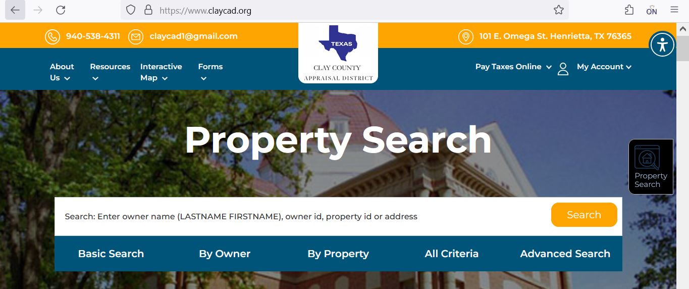
Clay CAD property search screenshot: what to check on the lookup page
The screenshot below shows the Clay CAD property search layout with the official top menu, property search box and search tabs. Use it as a visual guide before opening the live portal. Current values, exemptions, tax due and protest status must always be confirmed on the official live search page.
What Clay CAD property record fields usually mean
A Clay CAD record is an appraisal and tax-account reference. It helps you understand property identity, ownership shown for appraisal purposes, value, property type and tax due. It is not the same as a deed, title policy or land survey.
| Field | What it helps you find | How to use it correctly |
|---|---|---|
| Parcel ID | Unique parcel reference in the CAD search result | Use it when calling the CAD, paying taxes, searching again or matching a notice. |
| Account | Appraisal/tax account reference | Keep this number with your appraisal notice and tax-payment records. |
| Owner name | Owner shown on the appraisal record | Recent deed changes may take time. Use County Clerk records for recorded ownership proof. |
| Property address | Physical location when available | For rural land or mineral property, parcel ID or legal details may work better than address. |
| Legal / abstract / subdivision | Formal property description | Compare with deed, survey or county records if boundaries or title details matter. |
| Market value | CAD’s opinion of value for appraisal purposes | Compare with sales, condition, property type, acreage, improvements and nearby similar properties. |
| Base tax due | Tax due indicator shown in search results | Confirm payment amount and timing through Clay CAD’s official tax payment instructions before paying. |
| Property type | Real property, mineral property or other account type | Do not compare mineral property and real property accounts as if they are the same. |
Search Clay County property by owner, address, parcel ID or account
Most users try owner name or address first, but Clay County records may also involve rural land, mineral property, acreage and older legal descriptions. If one search fails, do not assume the property is missing.
- Try last name first.
- Use fewer words if the first search fails.
- Check all accounts under one owner.
- Do not confuse mailing address with the property address.
- Use street number and main road name first.
- Remove punctuation and abbreviations.
- Try partial road names for rural roads.
- Confirm legal description after opening the result.
- Use parcel ID from your notice if available.
- Search by account when you have tax paperwork.
- Use real property or mineral property filters.
- Use map view for location context.
Clay CAD interactive map and parcel research
The official Clay CAD site links to an interactive map. Use the map when you need parcel location, nearby roads, surrounding property context, rural acreage view or map-based research. It is helpful for understanding location, but it is not a legal survey.
How Clay County property tax payment works online
Clay CAD’s official payment page explains that online credit-card and e-check payments are made through Certified Payments. It also warns that payment posting can take 3 to 7 business days after funds are received by the Clay County Appraisal District Tax Office bank account.
Clay County homestead exemption and other appraisal exemptions
Exemptions can reduce taxable value when you qualify. Clay County homeowners should check homestead status after buying or moving, and rural owners should also review agricultural, special-use or other valuation issues where applicable.
How to protest a Clay County appraisal value online
A useful protest focuses on evidence. Clay CAD appraises property value and handles appraisal review. Your protest should show why the value is too high, why the appraisal is unequal, why property details are wrong, or why an exemption or special valuation issue needs review.
Evidence checklist for a Clay County appraisal review
Clay County includes homes, rural land, farms, ranches, business accounts and mineral property. Evidence should match the property type. A residential sale may not prove a mineral account value, and a rural land sale may not prove a city home value.
- Recent comparable sales near the property
- Photos of damage, age or poor condition
- Repair estimates from contractors
- Proof of wrong square footage or features
- Closing statement if recently purchased
- Acreage, survey or deed details
- Maps, access, fencing, water or terrain issues
- Ag-use or special valuation documents
- Photos showing actual land condition
- Comparable rural sales with similar use
- Rendition records
- Lease or production information where relevant
- Depreciation schedules
- Asset or equipment support
- Professional valuation support for complex accounts
Clay CAD vs Clay County Tax Assessor-Collector
Clay CAD provides appraisal records and an official online property-tax payment route. The county also lists the County Tax Assessor-Collector separately for elected tax-office duties. Use the correct office depending on what you need.
| Need | Correct office or route | What to ask or check |
|---|---|---|
| Property value, owner record or appraisal notice | Clay County Appraisal District | Market value, property characteristics, tax-year data, exemptions and appraisal notice questions. |
| Homestead, over-65, disability, veteran or ag/special valuation | Clay County Appraisal District | Forms, application status, supporting documents and deadlines. |
| Value protest or ARB hearing | Clay CAD / ARB process | Online protest, evidence, hearing procedures and deadline. |
| Clay County property-tax online payment | Clay CAD Pay Taxes Online / Certified Payments | Property ID, tax amount, bureau code, fees and payment confirmation. |
| County tax assessor services | Clay County Tax Assessor-Collector | County tax office services, vehicle-related tax-office needs and assessor-collector questions. |
| Recorded deed or legal property document | Clay County Clerk | Deeds, liens, recorded instruments and official document copies. |
Clay CAD forms, records, online protest and taxpayer tools
Use official Clay CAD pages instead of random PDF copies. The official site menu includes forms, property search, interactive map, online protest, records/data/reports, view protest hearings, pay taxes online, registration and sign-in tools.
| Official page | Use it for | Practical tip |
|---|---|---|
| Forms | Homestead, exemptions, appraisal forms and special-use paperwork | Download the latest form and call the office if you are unsure which one applies. |
| Property Search | Parcel ID, account, owner, address, market value and tax due review | Confirm tax year and property type before relying on the result. |
| Interactive Map | Parcel map, location context and rural property review | Use it for research, not as a legal survey. |
| Pay Taxes Online | Certified Payments credit-card or e-check payment route | Confirm property ID, tax amount, bureau code and fees before paying. |
| Contact Clay CAD | Phone, fax, email, chief appraiser and county official directory details | Use email for non-urgent questions; call for deadlines or payment issues. |
Clay County Appraisal District contact details
Use Clay CAD for appraisal value, exemptions, property search, online protest, forms, map questions and official property-tax account help.
| Contact item | Official detail | Best use |
|---|---|---|
| Office name | Clay County Appraisal District | Use for appraisal records, exemptions, property search, protests and tax-account questions. |
| Street address | 101 E. Omega St., Henrietta, TX 76365 | Use for office visit planning and map directions. |
| Mailing address | P.O. Box 108, Henrietta, TX 76365 | Use for mailed forms, written correspondence and account documents where accepted. |
| Phone | 940-538-4311 | Use for property search help, tax amount questions, exemptions and protest procedure. |
| Fax | 940-538-4725 | Confirm before faxing deadline-sensitive documents. |
| claycad1@gmail.com | Use for non-urgent written questions; call for deadlines or payment issues. | |
| Chief appraiser | Lisa Murphy | Official contact page lists Lisa Murphy as chief appraiser. |
| County Tax Assessor-Collector | Patti Jackson, 940-538-4356 | Use for county tax-assessor-collector duties separate from CAD appraisal questions. |
Clay CAD office map and visit planning
The Clay CAD office is located in Henrietta. If you are driving from Byers, Bellevue, Petrolia, Jolly, Bluegrove, rural Clay County or nearby Wichita Falls-area communities, call first so you do not make a long trip with the wrong form, missing property ID or payment confusion.
Official Clay County resources used in this guide
Use these official pages for final confirmation before filing forms, protesting a value, paying taxes, checking maps or visiting an office.
Official Clay CAD property search Official Clay CAD contact page Official Clay CAD interactive map Official Clay CAD forms page Official Clay CAD pay taxes online page Official Clay CAD records, data and reports route Official Clay CAD protest hearings routeClay County Appraisal District FAQs
What is the official Clay County Appraisal District website?
The official Clay County Appraisal District website is claycad.org. Use it for property search, forms, interactive map, online protest, pay taxes online, records/data/reports and CAD contact details.
How do I search Clay County property records online?
Open the official Clay CAD property search page and search by parcel ID, owner name, street name, street number, city, account, real property or mineral property. Confirm the tax year before relying on the result.
What is the Clay CAD phone number?
The main Clay County Appraisal District phone number is 940-538-4311. Use it for property search help, exemption questions, tax amount questions, online protest and account guidance.
Where is Clay County Appraisal District located?
Clay CAD shows the office address as 101 E. Omega St., Henrietta, TX 76365. The mailing address listed on the official contact page is P.O. Box 108, Henrietta, TX 76365.
Can I pay Clay County property taxes online?
Yes. Clay CAD provides a Pay Taxes Online page using Certified Payments. You need your property ID, tax amount and payment method. The official page also lists e-check and credit-card convenience fees.
What is the Clay CAD bureau code for phone payments?
The official Clay CAD payment page lists bureau code 5384311 for telephone credit-card payments through Certified Payments. Confirm your property ID and tax amount with Clay CAD before paying.
How do I apply for a Clay County homestead exemption?
Use the official Clay CAD forms page, download the correct exemption form, attach required ownership or identification documents and submit it through the official route. Keep proof of filing.
Can I file a Clay CAD protest online?
Clay CAD provides an online protest route through the official website menu. Use your appraisal notice, property ID and tax-year details to confirm the correct filing process and deadline.
What evidence helps in a Clay County appraisal protest?
Helpful evidence includes comparable sales, photos of damage or poor condition, repair estimates, closing statements, maps, acreage documents, mineral or lease documents and proof of incorrect property details.
Why can I not find a Clay County property by address?
Some rural, mineral or older records may not search cleanly by address. Try parcel ID, account, owner name, street name only, legal description, real property or mineral property filters.
Last editorial check: June 2026. Official details can change without notice; verify your account-specific information on ClayCAD.org and official county resources.

Founded by Mahesh Kumar, AppraisalDistrict.org is built on the belief that public information should be accessible and accurate. We have replaced AI-generated ‘fluff’ and automated scraping with 100% manual human verification. With over 15 years of experience in real estate and digital journalism, we help you find the right data without the frustration of broken links.
Search Smarter, Estimate Taxes, Check Exemptions and Prepare for a Protest
Use this free tool before you visit a county appraisal district, property search portal, tax office, or exemption page. It helps you understand property value, taxable value, possible savings, protest value, and the next official step.
What do you need help with today?
Choose your main reason for visiting. The tool will show the best next step and quick estimate.
Use this tool to check your appraisal notice, exemption savings, protest value, and official next step.
Use the tax calculator before trusting only the sale price or mortgage estimate.
Property Search Helper
Use this when a county property search portal is confusing. It shows which search method is usually best.
Property Tax Estimate Calculator
Estimate annual property tax using appraised value, assessment ratio, exemptions, and combined tax rate.
Homestead and Exemption Savings
Estimate how much a homestead, senior, disability, veteran, or local exemption may reduce tax.
Appraisal Notice Review
Compare last year value with this year value and see whether the increase deserves closer review.
Property Tax Protest Savings
Estimate possible savings if your appraised value is reduced after protest, correction, evidence review, or appraisal review board hearing.
Property Tax Protest and Exemption Checklist
Use this checklist before you file a protest, apply for exemption, or call the appraisal district.
Before calling, write your property ID, owner name, property address, and question on paper. It saves time.
Do not call the CAD to pay tax bills unless the local article says they collect taxes. In many counties, the tax office collects payment.
Official Resource Finder
Enter county and state to create safe searches for official CAD pages, property search, tax payment, exemptions, maps, forms, and protest help.
CAD vs Tax Office
- Appraisal District: value, exemptions, ownership records, maps, protest.
- Tax Office: tax bill, payment, receipt, delinquent balance, penalty.
Best place to use this
Add this tool after the first major content section or before the FAQ area. It gives visitors a reason to interact before leaving the page.
Important estimate note
This tool gives educational estimates only. Final values, exemptions, tax rates, bills, payments, and deadlines must be confirmed with official county sources.