Grayson County Appraisal District (Grayson CAD) 2026

Grayson County, Texas · Property search, maps, exemptions, protests, tax payments and deed records

Cross the Grayson County Property Record From Texoma Parcel to Verified Tax Receipt

Start with Grayson Central Appraisal District when you need a property ID, geographic ID, appraisal owner, legal description, land and improvement values, homestead exemption, agricultural appraisal, business account, map or protest record.

Use the Grayson County Tax Assessor-Collector for bills, balances, payment fees, receipts and delinquent taxes. Use the County Clerk for recorded deeds, mortgages, judgments, liens, plats and other legal property documents.

Property ID Geographic ID Owner or DBA Street or county road Abstract or subdivision Tax year
TEXOMA PARCEL BRIDGE ACCOUNT VERIFY
SEARCH → VERIFY → SAVE → PAY OR PROTEST
Do not treat the CAD owner field as a deed or the CAD value as a tax bill. Grayson CAD maintains appraisal information. The County Clerk controls recorded property documents, and the Tax Assessor-Collector controls bills, payments and receipts.
CAD search

Use esearch.graysonappraisal.org for appraisal accounts and parcel details.

Tax payment

Use tax.co.grayson.tx.us for balances, payments, receipts and estimates.

CAD office

512 North Travis Street, Sherman, Texas 75090.

Public hours

CAD office hours are 8:00-5:00; public access is 8:00-4:00.

Official review

Local portals and 2026 procedures reviewed July 31, 2026.

Start with the outcome

What are you trying to do with the Grayson County property?

FIND AN ACCOUNT Search the appraisal record

Use Owner, Address, ID or Advanced Search, then confirm the property and legal description.

Follow the search workflow
CHECK A VALUE Review every value component

Separate land, improvements, market value, cap loss, circuit breaker and taxable value.

Understand the account values
PAY PROPERTY TAX Leave the appraisal system

Use the Tax Office for live balances, fees, partial payments, installment plans and receipts.

Use the payment safeguards
PROTEST OR CORRECT Save the complete account first

Identify the exact value, exemption, land, building or ownership problem before filing.

Prepare a focused protest
CHECK A DEED Use County Clerk records

Search recorded instruments rather than treating the CAD owner field as title proof.

Review deed and lien steps
LAKE, RANCH, MUD OR BUSINESS Use advanced filters

Special locations and account types often require a geographic ID, abstract, subdivision, DBA or property type.

Review local scenarios

Go directly to the Grayson County property task

Start with parcel identity and appraisal data. Continue to tax payment, deed records, exemptions, agricultural appraisal or protest procedures only when those records control the answer.

Existing article image retained

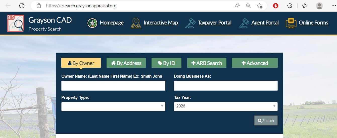
Use the Grayson CAD screenshot as a practical search guide

The existing article’s property-search image is preserved below. It shows the official interface and the five main search routes. The live portal may change, so perform the final lookup on the official system.

Grayson CAD property search showing Owner, Address, ID, ARB Search, Advanced Search and tax year fields
1. By Owner Enter the last name first. Use only one name when the complete owner name produces no result.
2. By Address Search the property location, not the owner’s mailing address. Remove the direction or street type when needed.
3. By ID Use the property ID from a CAD notice, prior property record or tax statement for the most precise search.
4. ARB Search Use protest status, informal date, hearing date, board member or formal-date fields where applicable.
5. Advanced Use abstract, subdivision, condo, mobile-home park, DBA, geographic ID, owner ID, neighborhood or property type.
6. Tax year Confirm the year before comparing values, exemptions, protests or appraisal history.
The screenshot is a navigation aid, not a current taxpayer record. Open the live account before filing, paying, estimating taxes or relying on the displayed value.
Advanced search routes

Use the Grayson CAD filter that matches the property

Official Grayson CAD fields and their best uses
Search field Best use What to verify
Owner name A person, estate, trust, company or joint owner. Try one name, alternate spelling or a business name.
Doing Business As Business and trade-name accounts. Legal owner, situs and Personal property type.
Property ID Opening the exact account from a notice or prior record. Tax year, property type and legal description.
Owner ID Finding multiple accounts connected to one owner. Each result may be a separate parcel or account type.
Geographic ID Matching the appraisal account to map and parcel information. It does not establish a surveyed boundary.
Abstract Rural acreage, farms and survey-based legal descriptions. Owner, tract, acreage and geographic ID.
Subdivision Residential additions, Lake Texoma lots and growing developments. Lot, block, phase, unit and property ID.
Condo Separately indexed condominium units. Unit number, common-area treatment and property ID.
Mobile-home park Manufactured homes linked to a named park. Whether the home and land are separate accounts.
Neighborhood Equal-appraisal comparison research. A CAD neighborhood is not automatically a sales-market boundary.
ARB fields Protest status, informal date, hearing date, board member and formal date. The written hearing notice and ARB order control.
Account-field decoder

Understand what the Grayson CAD record does and does not prove

Use each field as a route to the controlling record
Field What it identifies What it does not prove Best next action
Property ID The appraisal account used by Grayson CAD. That every county database uses the same number. Save it for CAD calls, forms and tax searches.
Geographic ID A geographic or parcel reference. A surveyed boundary or guaranteed acreage. Compare the deed, plat and survey.
Owner shown The owner maintained for appraisal administration. Clear title or the absence of liens and easements. Search County Clerk records.
Situs address The physical location carried in the CAD system. The mailing address or complete legal description. Compare the map, deed and assigned address.
Legal description An abbreviated lot, block, tract, survey or abstract reference. A complete deed-ready legal description. Open the recorded deed or plat.
Acreage Acreage used for appraisal purposes. Surveyed, fenced or legally guaranteed acreage. Use title evidence and a professional survey.
Market value CAD’s opinion of market value as of January 1. A guaranteed selling price or tax bill. Compare sales, property facts and equal-appraisal evidence.
HS cap loss Value excluded by the residence-homestead appraisal limitation. An exemption amount or permanent reduction in market value. Verify homestead status and prior-year appraised value.
Circuit breaker A qualifying non-homestead appraisal limitation. That the market value itself is capped at 20%. Confirm ownership timing, property type and eligibility.
Agricultural value Productivity value applied to qualifying land. Qualification continues after a sale or use change. Verify application status and rollback exposure.
Assessed or taxable value Value after applicable limitations or exemptions. The live balance, payment, penalty or receipt. Open the County Tax Office search.
Interactive parcel map

Use the Grayson CAD map without treating it as a survey

Open the official interactive map Open Grayson CAD Interactive Map
Locate the property using a known identifier Use the property ID, geographic ID, owner, address, abstract or subdivision where available.
Compare surrounding parcels Review roads, Lake Texoma shoreline, nearby subdivisions, rural tracts, MUD developments and approximate parcel shape.
Return to the appraisal account Confirm that the map parcel and CAD account share the correct identifiers and legal information.
Use legal records for legal decisions Obtain the deed, recorded plat, easements, title evidence and professional survey before resolving access or boundaries.
The public map is informational. Grayson CAD states that its mapping products are not on-the-ground surveys and are not suitable as legal, engineering or surveying documents.
2026 record status

Use the live account instead of relying on one downloaded appraisal file

Grayson CAD’s public-information page currently provides a 2026 certified appraisal export as well as a separate preliminary-data download. Each file represents a particular dataset and update point.
Live property account

Best for current parcel-specific research, values, exemptions, characteristics and history.

Certified export

Useful for bulk research and certified-roll analysis at the export’s publication point.

Preliminary export

Useful for reviewing appraisal data before final certification, but not for proving a final tax bill.

Tax Office ledger

Controls the live bill, payment status, penalty and receipt rather than the appraisal export.

Clerk record

Controls recorded instruments and should be used when legal ownership matters.

Dated evidence

Save the date, file name and source whenever using data in a protest or transaction review.

Value explanation

Separate market value, appraised value and taxable value

STEP 1 Market value

Grayson CAD’s opinion of what the property would sell for under normal market conditions as of January 1.

STEP 2 Appraised value

The value after an applicable homestead or non-homestead appraisal limitation.

STEP 3 Taxable value

The value remaining after exemptions for each county, city, school, college, watershed or MUD taxing unit.

Grayson County has many taxing combinations. A property can include Grayson County, a city, school district, Grayson College, Choctaw Watershed and one or more municipal utility districts. Review each account line rather than applying a countywide rate.
Do not multiply market value by one tax rate and call it the bill. The amount depends on taxable values, exemptions, adopted rates, ceilings, MUDs, payment history and penalties.
2026 appraisal limitation

Check whether non-homestead property qualifies for the circuit breaker

For 2026, the temporary Texas circuit-breaker limitation can apply to qualifying non-homestead real property valued at $5,320,000 or less. The limit concerns appraised value, not the district’s market-value opinion.
Maximum increase calculation

The limited appraised value generally cannot exceed the prior appraised value plus 20% and qualifying new improvements.

Ownership timing matters

The limitation generally begins after the owner owned the property on January 1 of the preceding year.

Market value can be higher

The account may show market value above the limited appraised value.

Homesteads use another limitation

Qualifying residence homesteads use the separate 10% appraisal-cap calculation.

Special-appraisal land is excluded

Qualifying agricultural and other specially appraised land does not receive this circuit breaker.

Temporary law

The current circuit-breaker provision expires after the 2026 tax year unless Texas law changes.

Grayson County mini tools

Route the task and estimate the current online payment fee

Property task router

Select the result you need. The tool will identify the correct official starting point.

Choose a task above. The official office and next step will appear here.

Online payment-fee estimate

Estimate the currently published vendor fee before opening checkout.

Current published fee structure E-check: $1.50. Credit card: up to 2.15%. Verify the live checkout amount.
Educational estimate only: the payment provider can change its fee. The final amount displayed during official checkout controls.
Appraisal-notice review

Read the Notice of Appraised Value before choosing a protest reason

Property identity

Confirm the owner, property ID, mailing address, situs address, property type and legal description.

Land and improvements

Review land and improvement values separately to identify where the change occurred.

Property characteristics

Check building area, age, class, condition, outbuildings, pools, mobile homes and percentage complete.

Exemptions

Verify homestead, age, disability, veteran and other expected benefits.

Agricultural appraisal

Check qualifying acreage, market value, productivity value and actual land use.

Protest deadline

Use the date printed on the individual notice rather than relying only on May 15.

Search troubleshooting

Fix common Grayson CAD search failures before calling the office

Change one search detail at a time
Problem Likely reason Practical fix
Owner name returns no result The account may use initials, spouse, trust, estate, company or another name order. Search only the first or last name, DBA or owner ID.
Too many owner matches The surname is common or the owner has multiple properties. Add address, property type, subdivision, geographic ID or owner ID.
Complete address fails The situs may omit a direction or street suffix. Enter the street number and street name only.
Rural tract has no normal address The parcel may be indexed by abstract, geographic ID or legal description. Use Advanced Search and the interactive map.
Lake Texoma lot opens the wrong parcel Several lots may share a road or subdivision name. Match lot, block, subdivision, property ID and geographic ID.
Manufactured home is missing The home may be a separate Mobile Home or Personal account. Use the property-type and mobile-home-park filters.
Business account is missing The account may be under a DBA or legal business owner. Search the DBA, owner ID, situs and Personal property type.
Recently purchased property shows seller The deed may still be processing into the appraisal system. Confirm recording with the Clerk and provide the instrument information to CAD.
MUD or taxing unit looks incorrect Fast-growing developments can have special-district boundaries. Compare the GIS parcel, legal description and Truth-in-Taxation record.
Tax balance differs from CAD value The systems serve different purposes. Use CAD for appraisal; use the Tax Office for the live bill and payments.
Prepared call script
I am researching Grayson CAD property ID [number] / geographic ID [number] for [address, subdivision or legal description]. The account currently shows [owner, value, exemption, building detail or taxing unit]. I need help with [exact issue] for tax year [year]. Which form, record or department controls this?
Grayson County situations

Local search tips for Sherman, Denison, Lake Texoma and growing MUD areas

Sherman residence

Check City of Sherman, Sherman ISD, Grayson County and Grayson College taxable values separately.

Denison property

Confirm Denison city and school lines and verify whether the property is inside another special district.

Pottsboro or Lake Texoma

Match subdivision, lot, block, shoreline location, road access and property ID before comparing values.

Van Alstyne or Gunter growth area

Review new subdivisions, MUD boundaries, percentage-complete improvements and current taxing units.

Whitesboro or Collinsville acreage

Use owner, abstract, geographic ID, acreage and agricultural classification.

Bells, Howe or Tom Bean

Confirm the exact city and school boundaries rather than relying only on the postal address.

Farm or ranch land

Review market value, productivity value, qualifying acreage, improvements and rollback exposure.

Manufactured home

Determine whether the home and land are assessed together or under separate accounts.

Business or industrial site

Search the real estate, business-personal-property and related entity accounts separately.

Office routing

Send each Grayson County property question to the office that controls it

APPRAISAL Grayson CAD

Values, exemptions, maps, property characteristics, agricultural appraisal and protests.

COLLECTION County Tax Office

Tax statements, balances, payments, receipts, penalties and installment options.

LEGAL RECORD County Clerk

Deeds, mortgages, judgments, tax liens, plats and certified recorded documents.

Choose the record owner before calling
Your question Correct starting point What to prepare
What is the market or appraised value? Grayson Central Appraisal District Property ID, tax year and disputed value field.
Why is an exemption missing? Grayson Central Appraisal District Application, qualification date and filing proof.
How do I protest? Grayson CAD and the Appraisal Review Board Notice, account, protest reason and evidence.
How much property tax is due? Grayson County Tax Assessor-Collector Tax account, owner, property location and tax year.
Did my payment post? Grayson County Tax Assessor-Collector Receipt, confirmation, date, amount and year.
Who legally owns the property? Grayson County Clerk or title professional Grantor, grantee, date range and legal description.
Where can I obtain a deed, lien or plat? Grayson County Clerk Names, document type, date and property description.
Is the acreage or boundary correct? Surveyor, title professional and Clerk records Deed, plat, easement and prior survey.
Why is a MUD on the account? CAD for boundary data; MUD and Tax Office for rates and billing Property ID, map, subdivision and taxing-unit list.
Who sets the tax rate? Each county, city, school, college, watershed or MUD governing body The taxing-unit list from the CAD account.
Record corrections

Correct the source of the inaccurate Grayson County information

Incorrect appraisal owner Confirm the recorded deed, probate document or ownership evidence and ask CAD what proof it requires.
Incorrect mailing address Use the district’s change-of-address process and preserve the submitted request.
Incorrect situs address Compare the assigned address, CAD map, city or county record and deed before requesting a correction.
Incorrect acreage or legal description Prepare the deed, plat and survey. The public map does not resolve a legal boundary dispute.
Incorrect improvement details Prepare measurements, photographs, building plans, demolition evidence and repair estimates.

Incorrect agricultural status Provide the application, acreage map, use history, leases and production evidence.

Incorrect MUD or taxing unit Compare the parcel map, subdivision documents and taxing-unit boundary information.

Incorrect payment or tax balance Contact the Tax Office with the account, year, receipt, amount and confirmation.

Exemption review

Verify Grayson County exemptions before estimating property taxes

Exemptions reduce taxable value rather than market value. Review every taxing-unit line because county, city, school, college, watershed and MUD treatment can differ.

Residence homestead

Texas school districts currently provide a $140,000 general residence-homestead exemption.

Age 65 or older

Review the additional exemption, school-tax ceiling, installment option and possible deferral.

Disabled person

Check qualification documents, additional exemption and applicable tax-ceiling protections.

Disabled veteran

Use the correct application and attach the required VA documentation.

Inherited homestead

Prepare deed, probate, heirship and occupancy information when the account remains in a deceased owner’s name.

Other exemptions

Use official forms for charitable, religious, disaster, Freeport, vehicle and other qualifying property.

Prepare these items before filing

Property ID and geographic ID
Owner name exactly as recorded
Property and mailing addresses
Texas driver license or identification
Occupancy or qualification date
Age, disability or VA documentation
Deed, heirship or probate evidence
Submission confirmation or mailing proof
Grayson CAD states that homestead applications must include a driver license or other information required by the Texas Property Tax Code. An affidavit may be required in some situations.
Agricultural and wildlife appraisal

Prepare local agricultural evidence before filing with Grayson CAD

Farm or ranch use

Prepare acreage, crops, livestock, leases, production records, expenses and management history.

Wildlife management

Confirm prior qualification and prepare the current plan and annual activity records.

Beekeeping

Use the district’s local beekeeping report and document hive count, acreage, location and management.

Agricultural appraisal preparation
Evidence What it helps establish Practical preparation
Acreage map Qualifying, homesite and nonqualifying areas. Label pasture, cultivated land, wildlife, structures and excluded acreage.
Production history Actual agricultural use and intensity. Keep crop, livestock, feed, seed, lease and sales records.
Lease documents Who conducts the agricultural activity and under what terms. Identify the parcel, acreage, duration and responsibilities.
Wildlife plan Qualifying wildlife-management practices. Document activities, dates, locations, photographs and results.
Beekeeping report Local beekeeping use and management. Document hive placement, ownership, inspections and activity dates.
Late agricultural applications: Grayson CAD states that an application filed before the ARB approves the appraisal records may be accepted with a 10% penalty on the tax difference.
Special appraisal may not transfer automatically. Buyers and heirs should verify qualification, filing requirements and rollback-tax exposure before changing the land’s use.
Business personal property

File the 2026 Grayson CAD rendition by April 15

Identify income-producing property owned on January 1 Review furniture, fixtures, machinery, equipment, inventory, supplies, vehicles and other tangible business property.
Search for the existing account Use the legal owner, DBA, owner ID, situs and Personal property type.
Use the current rendition and depreciation schedule Grayson CAD publishes a 2026 depreciation schedule and current rendition forms. Open Grayson CAD business property guidance
File or request an extension by April 15 at 11:59:59 p.m. CST A granted extension moves the rendition deadline to May 15 at 11:59:59 p.m. CST.
Avoid the late-rendition penalty Grayson CAD states that failure to file a timely rendition can result in a penalty equal to 10% of the tax liability.
Use online filing when appropriate The district states that online forms are available for all business-personal-property accounts.
Keep complete proof Save the signed rendition, asset schedules, extension request and submission confirmation.
Effective for 2026, income-producing tangible personal property with a total taxable value of $125,000 or less in a taxing unit may qualify for the statutory business-personal-property exemption.
Value and appraisal disputes

File a Grayson CAD protest around one specific issue

Normal filing rule: protest by May 15 or within 30 days from the date of the Notice of Appraised Value, as applicable. The deadline printed on the notice controls.
Save the complete property account Keep the property ID, legal description, land, improvements, values, exemptions, cap information and property characteristics.
Choose the correct protest reason Possible issues include market value, unequal appraisal, incorrect property data, exemption denial, agricultural denial or another CAD action.
File through the Taxpayer Portal or official form Preserve the confirmation, email, fax record, certified-mail receipt or stamped copy. Open the Taxpayer Portal
Request the district’s evidence Review the property characteristics, comparable sales, land schedules, depreciation and valuation method.
Build evidence around the protest reason Use comparable sales, equal-appraisal examples, photographs, repair estimates, surveys, closing statements or agricultural records.
Attempt an informal resolution Present a short written summary and review any proposed adjustment before the formal hearing.
Prepare a concise ARB presentation State the requested value or correction, explain the strongest evidence and respond directly to the district’s evidence.
Preserve the written ARB order The order applies to the protested year and starts the deadline for any further appeal.

Evidence packet checklist

Notice of Appraised Value
Dated Grayson CAD account
One-page requested-value summary
Comparable sales or equal-appraisal table
Dated photographs
Repair estimates or professional reports
Measurements, survey or acreage evidence
CAD evidence with disputed items marked
“My tax bill is too high” is not a complete appraisal argument. Grayson CAD determines values and exemptions. Local governing bodies adopt tax rates.
After the normal deadline

Use Grayson CAD’s published late-protest route carefully

The normal online protest portal does not accept late protests. Grayson CAD publishes separate submission methods, but filing documents does not guarantee that the ARB has jurisdiction to hear the late protest.
Check the date on the appraisal notice If the notice was received after May 15, the official district guidance states that a protest may still be timely within 30 days from the notice date.
Prepare a written explanation Explain why the protest is late and identify the property, owner, tax year and disputed CAD action.
Choose a published submission method Grayson CAD lists email, fax, secure office dropbox and the ARB evidence-upload route.
Use the official contact details Email webmaster@graysonappraisal.org, fax 903-892-3835 or use the dropbox outside 512 North Travis Street.
Keep proof of delivery Save the sent email, fax confirmation, upload confirmation or a photograph and time record of the dropbox submission.
Ask what happens next Confirm whether the submission is considered timely, requires a good-cause determination or will receive a hearing.

ARB evidence upload

Format and upload Grayson CAD protest evidence correctly

Grayson CAD’s evidence-upload page accepts PDF, Word, Excel, JPEG, PNG and TIFF files. The combined upload limit is 20 MB per property. The ARB cannot review audio or video files through this process.
Create one evidence packet for each property ID Do not combine evidence for several protested properties into one unlabeled upload.
Convert video or audio evidence into reviewable documents Use dated still images, written transcripts or reports because the ARB cannot view or listen to those media files.
Keep the total file size below 20 MB Compress photographs and split documents when necessary without making evidence unreadable.
Use the requested name fields correctly Grayson CAD instructs users to place the property ID in the First Name field and the owner’s last name in the Last Name field.
Wait for the green upload confirmation A green check indicates that the upload completed successfully.
Keep your original files The upload page states that users cannot reopen files they already uploaded.

Electronic property services

Use the Grayson CAD Taxpayer Portal for protests, documents and applications

The current Grayson CAD Taxpayer Portal was updated July 15, 2026. It allows users to access property details, file an online protest, elect electronic communication, review documents and manage applications.
Open the official Taxpayer Portal Open Grayson CAD Taxpayer Portal
Create an account with an active email address Use an email account you monitor and create a secure password.
Connect the correct property Match the owner name, property ID and account information before submitting anything.
Monitor approval status A new registration may display “Approval Pending” while CAD reviews the account.
Save every confirmation Keep protest, application, electronic-delivery and document-upload confirmations.
Check email and spam folders Electronic communication remains in effect until rescinded in writing, and missed email does not automatically extend a deadline.

Bills, payments and receipts

Move from the Grayson CAD account to the official tax ledger

The CAD record explains appraisal values and exemptions. The Grayson County Tax Assessor-Collector’s official system controls the live balance, payment history, penalties and receipt.

Open the official Tax Office property search Search and Pay Grayson County Property Tax
Choose the strongest search field Use the account number with required dashes when available. Otherwise search the owner, mailing address or property location.
Simplify a property-location search The Tax Office instructs users not to enter the street type or direction. Use the street number and name.
Confirm the correct property and tax year Compare the owner, account number, property location, legal information and balance.
Review current and delinquent amounts Check partial payments, penalty, interest and attorney-collection charges before continuing.
Review the payment fee The Tax Office currently publishes a $1.50 e-check fee and a credit-card convenience fee of up to 2.15%.
Save complete proof Keep the account, tax year, amount, fee, payment method, date and confirmation number.
Confirm payment posting Reopen the account after processing and verify that payment reached the intended property and year.

Grayson County property-tax payment options
Payment option Current published information What to verify
Online e-check $1.50 per e-check Bank information, account, year and confirmation.
Online credit card Up to 2.15% vendor convenience fee Final checkout fee and payment total.
In person Cash, check, money order, cashier’s check, Discover, Visa and Mastercard Location hours and receipt before leaving.
Partial payment Accepted in any amount Remaining balance and penalty after January 31.
Quarter payments Available for qualifying over-65, disabled or disaster-damaged homesteads January 31, March 31, May 31 and July 31 installments.
Tax deferral Potentially available through the appraisal district for qualifying homeowners Interest, lien consequences and qualification before filing.

Delinquency costs can increase quickly

Standard cumulative penalty and interest published by the Tax Office
Month paid Penalty Interest Total addition
February 6% 1% 7%
March 7% 2% 9%
April 8% 3% 11%
May 9% 4% 13%
June 10% 5% 15%
July 12% 6% 18%
Additional collection fees can apply. The Tax Office states that an additional 20% attorney fee may be added April 1 to unpaid business-personal-property and mobile-home accounts and July 1 to unpaid real-property accounts.
Tax Office branches

Choose the nearest Grayson County Tax Office location

Sherman main office
100 West Houston Street
Sherman, Texas 75090

Phone: (903) 892-8297
Monday: 8:00 AM-5:00 PM
Tuesday-Friday: 8:00 AM-4:30 PM

Denison office
101 West Woodard
Denison, Texas 75020

Phone: (903) 465-2101
Monday-Friday: 9:00 AM-4:30 PM

Whitesboro office
509 North Union
Whitesboro, Texas 76273

Phone: (903) 564-7786
Monday-Friday: 9:00-11:00 AM and 1:00-4:00 PM

Van Alstyne office
117 South Main
Van Alstyne, Texas 75495

Phone: (903) 482-6004
Monday-Friday: 9:00-11:00 AM and 1:00-4:00 PM

Call before travelling. Branch hours, holiday closures, payment methods and service availability can change.
Tax-rate transparency

Review proposed rates and property-specific estimates

Open the Grayson County Truth-in-Taxation portal Open Grayson County Tax-Rate Information
Search the property Use the owner, address or property information available in the portal.
Review every taxing unit Check the county, city, school, college, watershed and MUD units connected to the parcel.
Watch updates during August and September The database is updated as local governing bodies propose and adopt tax rates.
Direct rate comments to the governing body Grayson CAD cannot change a rate adopted by a city, school, county, college, watershed or MUD.
Return to the Tax Office for the bill Truth-in-Taxation information does not replace the official balance or payment receipt.

Recorded property documents

Use the Grayson County Clerk for deeds, mortgages, liens and plats

The Grayson County Clerk maintains Official Public Records from 1846 to the present, including deeds, land patents, mortgages, judgments and tax liens.
Open the official Real Property page Use the County Clerk’s instructions, online deed-search route and record-request information. Open Grayson County Real Property Records
Prepare the search names Gather the grantor, grantee, spouse, estate, trust, company and former-owner names.
Choose an appropriate date range Use the purchase date, loan date, inheritance period or approximate recording year.
Review the document type Look for deeds, mortgages, judgments, tax liens, releases, easements, mineral instruments and plats.
Compare the legal description Confirm the subdivision, lot, block, abstract, survey and acreage against the CAD account.
Request the correct copy Ask whether a plain or certified copy is required for the intended use.
Use a title professional for title conclusions A public index does not replace a title examination, legal advice or professional survey.

Property Deed Records
Grayson County Courthouse
100 West Houston Street, Suite 17
Sherman, Texas 75090

Real Property: (903) 813-4239
General: (903) 813-4200, extension 4281
Email: deeds@co.grayson.tx.us

Property-record hours

Monday, Tuesday, Thursday and Friday: 8:00 AM-4:30 PM.

Wednesday: 8:30 AM-4:30 PM.

The Clerk warns that Property Records may close from 12:00-1:00 PM. Call before visiting.

Plats are accepted for filing only until 4:00 p.m. County subdivision plats may also require approval from Commissioners Court before filing.
Advanced property research

Use Grayson CAD exports, map files and evidence requests

2026 certified export

Bulk appraisal and ownership data from the district’s certified dataset.

Preliminary export

Pre-certification appraisal data for research and comparison.

GIS shapefile

Downloadable mapping data for users with appropriate GIS software and skills.

Code lists

Entity, exemption, subdivision, neighborhood and appraisal code descriptions.

ARB evidence packet

Request the evidence the district intends to use in a protest.

Hearing recording

Use the public-information process to request an available hearing recording.

Reappraisal plan

Review the district’s 2025-2026 reappraisal planning document.

Appraisal schedules

Review residential classes, cost schedules, outbuildings and new-construction completion schedules.

Bulk data has limitations. A shapefile or export does not replace the current property account, tax ledger, deed or professional survey.
New construction and building plans

Submit plans or verify percentage complete when construction changes the account

New home or commercial building

Check whether the account includes the correct structure, square footage, class and completion percentage.

Partially complete improvement

Document the January 1 construction stage with dated photographs, contracts and inspection records.

Demolition or major damage

Provide demolition permits, photographs, repair reports and dates showing the property’s condition.

Open the Submit Building Plans page Open Grayson CAD Building Plan Upload
Select the correct city or “Not Listed Above” The district provides separate upload routes for cities and unlisted locations.
Upload building-plan documents only Grayson CAD specifically encourages users to keep this upload route limited to building plans.
Include the property identifier Label the file with the property ID, owner, address, project and relevant date.
Recheck the account Confirm that the property characteristics and percentage complete are updated accurately.

Buyer, heir and owner checks

Complete these checks before relying on a Grayson County property record

Confirm the parcel

Match property ID, geographic ID, legal description, subdivision, abstract, location and acreage.

Review every tax year

Check current and delinquent balances, partial payments, penalties and attorney fees.

Search recorded documents

Review deeds, mortgages, judgments, liens, releases, easements and plats.

Recalculate exemptions

The seller’s homestead exemption, appraisal cap and tax ceiling may not transfer to the buyer.

Check taxing units and MUDs

Identify every city, school, college, watershed and municipal utility district.

Review property characteristics

Compare square footage, age, class, condition, land type, pools and outbuildings.

Verify agricultural use

Confirm productivity value, qualifying acreage, use history and rollback exposure.

Confirm access and boundaries

Use recorded easements, subdivision plats, title evidence and a professional survey.

Save transaction evidence

Keep the deed, title policy, survey, closing statement, tax certificate and exemption filing proof.

The seller’s current bill may understate the buyer’s future taxes. Exemptions, appraisal limitations, new improvements and MUD obligations can change the future taxable amount.
2026 property-tax calendar

Important Grayson County appraisal and payment dates

Property status and valuation date Ownership, use, condition and market value are generally considered as of January 1.
Business personal property rendition Renditions and extension requests are due by 11:59:59 p.m. CST.

Most exemption and agricultural applications Many applications are due before May 1, subject to specific late-filing provisions.

Usual appraisal protest deadline File by May 15 or within 30 days from the notice date, as applicable.

ARB hearing season Grayson CAD published multiple ARB hearing dates from June through July 2026.

Tax-rate proposals and adoption Truth-in-Taxation data is updated as local governing bodies propose and adopt rates.

Tax statements generally arrive The Tax Office states that bills are normally mailed in late October or early November and are due upon receipt.

Normal payment deadline January 31 is generally the last day to pay without penalty and interest.

Penalty and interest generally begin Most unpaid property taxes become delinquent on February 1.

Possible additional BPP or mobile-home collection fee An additional 20% attorney fee may apply to unpaid personal-property accounts.

Possible additional real-property collection fee An additional 20% attorney fee may apply to unpaid real-property accounts.

Mail postmarks require extra attention. USPS policy changes can delay when an automatic postmark is applied. For deadline-sensitive filings or payments, request a retail-counter postmark or use an approved trackable or electronic method.
The property-specific document controls. Follow the deadline printed on the appraisal notice, application, hearing order or tax statement.
Verified local contacts

Grayson County appraisal, tax and property-record offices

Grayson Central Appraisal District
512 North Travis Street
Sherman, Texas 75090

Phone: (903) 893-9673
Fax: (903) 892-3835
General: webmaster@graysonappraisal.org

Chief Appraiser: Shawn Coker, RPA, CCA

Office hours: Monday-Friday, 8:00 AM-5:00 PM.

Public access: Monday-Friday, 8:00 AM-4:00 PM.

Useful Grayson CAD emails

Taxpayer Liaison: tlo@graysonappraisal.org
ARB help: arbonlinehelp@graysonappraisal.org
Exemptions: exemptions@graysonappraisal.org
Renditions: renditions@graysonappraisal.org
Agent forms: aoa@graysonappraisal.org

Grayson County Tax Assessor-Collector
100 West Houston Street
Sherman, Texas 75090
Mailing: P.O. Box 2107, Sherman, Texas 75091

Phone: (903) 892-8297
Fax: (903) 868-1295

Tax Assessor-Collector: Bruce Stidham, PCAC

Main office hours: Monday 8:00 AM-5:00 PM; Tuesday-Friday 8:00 AM-4:30 PM.

Grayson County Clerk
Grayson County Courthouse
100 West Houston Street, Suite 17
Sherman, Texas 75090

Main: (903) 813-4200, extension 4281
Real Property: (903) 813-4239
Email: deeds@co.grayson.tx.us

County Clerk: Deana Patterson

Official action links

Official Grayson County property resources

Grayson CAD homepage

Use for current notices, contacts, forms and appraisal information.

Open Grayson CAD
Property search

Search Owner, Address, ID, ARB and Advanced account fields.

Open property search
Interactive map

Review approximate parcel location and surrounding properties.

Open interactive map
Taxpayer Portal

Access property details, online protests, documents and applications.

Open Taxpayer Portal
CAD forms

Find homestead, veteran, rendition, protest and other appraisal forms.

Open CAD forms
Agricultural forms

Find local guidelines, application, wildlife and beekeeping forms.

Open agricultural forms
Evidence upload

Upload qualifying ARB evidence by property ID.

Open evidence upload
Public data

Access 2026 exports, map files, code lists and records requests.

Open public information
Search and pay taxes

Review balances, payment history and online payment options.

Open Tax Office search
Tax estimator

Estimate taxes by city, school, college, MUD and exemption.

Open tax estimator
Truth in Taxation

Review proposed rates, adopted rates and estimated taxes.

Open tax-rate portal
County Clerk records

Search or request deeds, mortgages, liens, judgments and plats.

Open Real Property records
Grayson County answers

10 common Grayson CAD and property-tax questions

1. What is the official Grayson CAD website?

The official Grayson Central Appraisal District website is graysonappraisal.org. Use it for property search, maps, exemptions, online forms, protests, evidence upload and district contacts.

2. How do I search Grayson County property records?

Use the official Grayson CAD property search. Search by owner, address or property ID, or use Advanced Search for abstract, subdivision, condo, mobile-home park, DBA, geographic ID and other fields.

3. Why does my Grayson CAD owner or address search show no result?

Try only the first or last name. For an address, enter the street number and name without the direction or street type. Rural and lake-area parcels may be easier to find by property ID, geographic ID, abstract or map.

4. Does a Grayson CAD record prove legal ownership?

No. The CAD record is maintained for appraisal administration. Use the Grayson County Clerk for recorded deeds, mortgages, judgments, tax liens, plats and certified property documents.

5. How do I pay Grayson County property taxes online?

Use the official Grayson County Tax Office search. Confirm the account, property, tax year and balance, review the fee and save the receipt.

6. What fees apply to online Grayson County tax payments?

The Tax Office currently publishes a $1.50 fee for each e-check and a credit-card convenience fee of up to 2.15%. Verify the live fee during checkout.

7. What is the Grayson CAD protest deadline for 2026?

The usual deadline is May 15 or 30 days from the date of the Notice of Appraised Value, as applicable. The deadline printed on the individual notice controls.

8. Can I still submit a Grayson CAD protest after the normal deadline?

Grayson CAD publishes a late-protest process using email, fax, office dropbox or evidence upload. Its normal online protest portal does not accept late protests. Include an explanation and ask whether the ARB can hear the matter.

9. Can I use the Grayson CAD map or acreage as a legal survey?

No. Grayson CAD states that its GIS boundaries, legal descriptions and acreage are for research and appraisal use. Obtain recorded documents, title evidence and a professional survey.

10. Where is Grayson Central Appraisal District located?

Grayson CAD is located at 512 North Travis Street, Sherman, Texas 75090. Its phone number is (903) 893-9673. Office hours are 8:00 AM-5:00 PM, with public access from 8:00 AM-4:00 PM.

Leave a Comment