
Jim Hogg CAD Property Search, Forms, Protest, Tax Office and Payment Help
Jim Hogg County property records can include homes in Hebbronville, ranch land, mineral interests, personal property, tax-due accounts and exemption records. A simple owner search is often enough, but ranch, mineral and business records may need property ID, Geo ID, lease number, legal description or advanced filters.
This guide helps you use the official Jim Hogg CAD search correctly, download forms, prepare exemption filings, understand protest steps, contact the tax office, and avoid common mistakes before paying, mailing documents or relying on a value.
Quick Answer for Jim Hogg County Property Owners
Use Jim Hogg CAD for appraisal values, property search, owner lookup, real property, mineral property, personal property, exemptions, appraisal forms, online protest, protest hearings, records, data reports and appraisal-office questions.
Use the Jim Hogg County Tax Assessor-Collector for tax bills, payment questions, tax statements and county tax-office matters. The Texas Comptroller directory lists Jim Hogg County as the collecting unit and Norma Liza S. Hinojosa as Tax Assessor-Collector.
Official Jim Hogg CAD and County Resources
Start from official resources when checking property records, filing forms, preparing a protest or confirming tax-payment details. This helps avoid outdated forms, copied phone numbers and unofficial payment pages.
| Need | Official Resource | Use It For |
|---|---|---|
| CAD homepage | Jim Hogg County Appraisal District | Main official site, property search, forms, online protest, interactive map, records, reports, policies and contact details. |
| Property search | Jim Hogg CAD Property Search | Search by keyword, owner, property ID, Geo ID, legal description, lease number, property type, protest status or agent. |
| Forms | Jim Hogg CAD Forms | Homestead, disabled veteran, business personal property rendition, agricultural use appraisal and electronic delivery request forms. |
| Online protest | Jim Hogg CAD Online Protest | Online protest access when your notice or account allows electronic protest filing. |
| Protest hearings | View Protest Hearings | ARB/protest hearing information when available through the official CAD website. |
| Interactive map | Jim Hogg CAD Interactive Map | Parcel location, rural tract context, nearby property review and map-based research. |
| Tax office | Jim Hogg County Tax Office | Tax bills, payments, receipts, tax statements and tax office questions. |
| State verification | Texas Comptroller Jim Hogg Directory | Cross-check CAD chief appraiser, phone, fax, address, active taxing units, tax office details and collecting unit. |
How to Search Jim Hogg County Property Records
The official Jim Hogg CAD search is more detailed than a basic owner-name lookup. It supports Basic Search, By Owner, By Property, All Criteria and Advanced Search, which is useful for Hebbronville homes, ranch land, mineral accounts, personal property and tax-due research.
Open the official search page
Go to the official Jim Hogg CAD website and use the property search area. Use this before paying a third-party website for basic appraisal data.
Choose the right search tab
Use Basic Search for broad lookup, By Owner for owner-name research, By Property for property ID, Geo ID, address or legal search, and Advanced Search when you need property type, protest status, lease or agent filters.
Select the correct tax year and property type
The official search supports recent tax years and property types such as MINERAL, PERSONAL and REAL. This matters because mineral and ranch-related records may not appear like a normal street-address property.
Use simple search terms first
For owner search, try LASTNAME FIRSTNAME or last name only. For address search, try street name only. For mineral, lease or ranch records, try property ID, Geo ID, lease number, lease name or legal description.
Open and save the full record
Review owner name, mailing address, property address, legal description, land size, improvements, exemptions, tax due, tax year, taxing units and protest status. Save a screenshot or PDF before filing, calling or paying.
Jim Hogg County search tip: If a property is ranch land, mineral interest, lease-related, inherited land or business personal property, do not rely only on street address. Use Advanced Search, property type, Geo ID, legal description and lease fields when available.
Visual Search Guide: Existing Jim Hogg CAD Search Screenshot
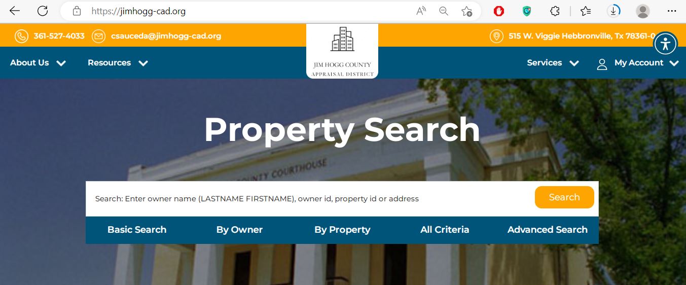
Practical note: This image is useful because many failed searches happen from using one search method only. If a basic search fails, switch to owner, property, all criteria or advanced search before assuming the record is missing.
Jim Hogg CAD Forms: Homestead, Disabled Veteran, Rendition and Ag Use
Jim Hogg CAD’s official forms page includes exemption forms, rendition forms, agricultural appraisal forms and electronic delivery request forms. Use the official CAD page because copied PDFs may be outdated or missing the correct mailing instructions.
| Situation | Likely Starting Point | What to Prepare |
|---|---|---|
| You live in the home as your primary residence | Homestead Exemption Form | Owner details, property ID, property address, Texas driver’s license or required ID information and correct mailing address. |
| You are a disabled veteran or qualifying survivor | Disabled Veteran’s Exemption Form | Ownership details, property ID, disability/veteran documentation and the correct tax year. |
| You own taxable business assets | Business Personal Property Rendition Form | Asset list, purchase year, cost records, inventory details, location and business ownership information. |
| You own agricultural/open-space land | Agricultural Use Appraisal Form 1-D-1 | Land-use history, acreage, production records, leases, maps, photos and supporting evidence. |
| You want electronic communications | Request for Electronic Delivery of Communications with a Tax Official | Owner details, email address, property/account information and signed request. |
Homestead document warning: Jim Hogg CAD’s forms page says all homestead applications must be accompanied by a copy of the applicant’s driver’s license or other information required by the Texas Property Tax Code. Missing proof can delay processing.
Completed forms should follow the official Jim Hogg CAD mailing guidance. The forms page says to mail completed forms to Jim Hogg County Appraisal District, P.O. Box 459, Hebbronville, TX 78361.
How to Prepare a Jim Hogg CAD Protest
A strong protest explains the exact appraisal issue. Do not only say “my taxes are high.” Explain whether the problem is market value, unequal appraisal, wrong acreage, missing exemption, wrong property type, mineral/lease details, business personal property or incorrect improvements.
Read your Notice of Appraised Value
Check property ID, proposed market value, appraised value, exemption status, protest instructions, hearing details and filing deadline.
Compare the CAD record carefully
Review acreage, legal description, real/mineral/personal classification, owner address, improvements, exemptions, lease details, protest status and prior-year value.
Collect evidence that fits the issue
Evidence may include comparable sales, photos, repair estimates, surveys, lease records, business asset lists, maps, ag-use records or proof that CAD details are wrong.
Use official protest access
Use the official Jim Hogg CAD Online Protest option if your account or notice allows electronic filing, or contact Jim Hogg CAD for the correct process before the deadline.
Keep proof of filing
Save confirmation screens, email receipts, mailed receipts, uploaded evidence lists or stamped copies. This matters if there is a deadline dispute.
Deadline warning: Always follow the protest deadline printed on your official notice or confirmed directly by Jim Hogg CAD. Do not wait for perfect evidence if the deadline is close.
Jim Hogg County Tax Office: Bills, Payments and Tax Statements
Jim Hogg CAD handles appraisal values and property records. Jim Hogg County Tax Assessor-Collector handles tax-office matters. The Texas Comptroller directory lists Jim Hogg County as the collecting unit and lists the tax office website, phone, email, mailing address and street address.
Before paying: Confirm property ID, owner name, tax year, amount due, payment method, receipt and mailing instructions directly through the official tax office website or tax office contact information.
Common Jim Hogg CAD Search Problems and Fixes
| Problem | Likely Reason | Try This |
|---|---|---|
| Owner name is not found | Record may use a trust, estate, company, spouse, ranch name, lease name or different spelling. | Search last name only, owner ID, property ID or Advanced Search. |
| Address search gives no result | Rural property, ranch property or mineral records may not have standard street-address formatting. | Use property ID, Geo ID, legal description, lease number, owner name or map/list results. |
| Mineral or lease property is hard to find | Mineral records may be tied to lease number, lease name, operator, owner ID or legal description. | Use Advanced Search filters and try lease number, lease name, property type MINERAL and legal description. |
| Business personal property is missing | It may be filed under a business name, owner ID or PERSONAL property type. | Filter property type PERSONAL and search business name, owner name or property ID. |
| Tax due does not appear as expected | Wrong tax year, payment timing, account mismatch or tax-office update delay. | Check the correct year and contact the Jim Hogg County Tax Assessor-Collector with account details ready. |
Documents to Keep Ready Before Calling
A prepared call is faster, especially during appraisal notice, protest, exemption, rendition and tax-payment periods.
- Owner name shown on the CAD record
- Property ID, Geo ID, account number or legal description
- Property address, ranch name or lease details if relevant
- Tax year you are asking about
- Notice of Appraised Value
- Photos, sales proof, lease records, rendition documents, ag-use records or exemption proof
- Tax year and amount due
- Property account or statement reference
- Owner name and mailing address
- Any payment confirmation if already paid
- Tax statement or delinquent notice
- Screenshot of search result showing tax due if applicable
Jim Hogg CAD and Tax Office Phone, Address, Hours and Map
Hebbronville, TX 78361-3062
Mailing: P.O. Box 459, Hebbronville, TX 78361-0459
Phone: 361-527-4033
Fax: 361-527-4034
Email: csauceda@jimhogg-cad.org
Interim Chief Appraiser: Celina Sauceda
Hours commonly shown by the current article: Monday-Friday, 8:00 AM-12:00 PM and 1:00 PM-5:00 PM
205 E. Tilley Street
Hebbronville, TX 78361-3523
Mailing: P.O. Box 160, Hebbronville, TX 78361-0160
Phone: 361-527-3237
Fax: 361-288-1640
Email: norma.l.hinojosa@co.jim-hogg.tx.us
Collecting Unit: Jim Hogg County
Visit tip: CAD and tax office addresses are different. Jim Hogg CAD is at 515 W. Viggie Street. The tax office is at 205 E. Tilley Street. Check which office handles your task before driving or mailing forms.
Jim Hogg County Appraisal District FAQs
What is the official Jim Hogg County Appraisal District website?
The official website is jimhogg-cad.org. Use it for property search, forms, online protest, interactive map, records, reports, public information and CAD contact details.
How do I search Jim Hogg County property records online?
Use the official Jim Hogg CAD property search on the CAD website. It supports Basic Search, By Owner, By Property, All Criteria and Advanced Search.
Can I search mineral property in Jim Hogg CAD?
Yes. The search page includes property type filters such as MINERAL, PERSONAL and REAL. For mineral records, try property ID, Geo ID, legal description, lease number or lease name.
Where is Jim Hogg County Appraisal District located?
Jim Hogg County Appraisal District is located at 515 W. Viggie Street, Hebbronville, TX 78361-3062. The mailing address is P.O. Box 459, Hebbronville, TX 78361-0459.
What is the Jim Hogg CAD phone number?
The Jim Hogg CAD phone number is 361-527-4033. The fax number is 361-527-4034 and the email is csauceda@jimhogg-cad.org.
Who is the Jim Hogg CAD chief appraiser?
The Texas Comptroller county directory lists Celina Sauceda as Interim Chief Appraiser for Jim Hogg County Appraisal District.
Where do I get Jim Hogg CAD homestead exemption forms?
Use the official Jim Hogg CAD forms page. It lists homestead exemption, disabled veteran exemption, business personal property rendition, agricultural use appraisal and other property tax forms.
Does Jim Hogg CAD require a driver’s license with homestead applications?
Yes. The official forms page says all homestead applications must be accompanied by a copy of the applicant’s driver’s license or other required information under the Texas Property Tax Code.
Who handles Jim Hogg County property tax payment questions?
The Jim Hogg County Tax Assessor-Collector handles tax office matters. The Texas Comptroller directory lists Norma Liza S. Hinojosa, phone 361-527-3237, and Jim Hogg County as the collecting unit.
Is AppraisalDistrict.org the official Jim Hogg CAD website?
No. AppraisalDistrict.org is an independent informational guide. Always verify property values, exemptions, protest deadlines, tax payments, forms and office procedures with Jim Hogg CAD, Jim Hogg County official resources or the Texas Comptroller.
Independent Guide and Verification Reminder
AppraisalDistrict.org is not the official Jim Hogg County Appraisal District website. This page is an independent guide created to help users find official resources faster and understand which office or portal to use.
Always confirm property values, exemptions, tax bills, tax-due status, protest deadlines, mineral/personal property records, forms, payment instructions and office procedures directly with Jim Hogg CAD, Jim Hogg County official resources or the Texas Comptroller before taking action.

Founded by Mahesh Kumar, AppraisalDistrict.org is built on the belief that public information should be accessible and accurate. We have replaced AI-generated ‘fluff’ and automated scraping with 100% manual human verification. With over 15 years of experience in real estate and digital journalism, we help you find the right data without the frustration of broken links.
Search Smarter, Estimate Taxes, Check Exemptions and Prepare for a Protest
Use this free tool before you visit a county appraisal district, property search portal, tax office, or exemption page. It helps you understand property value, taxable value, possible savings, protest value, and the next official step.
What do you need help with today?
Choose your main reason for visiting. The tool will show the best next step and quick estimate.
Use this tool to check your appraisal notice, exemption savings, protest value, and official next step.
Use the tax calculator before trusting only the sale price or mortgage estimate.
Property Search Helper
Use this when a county property search portal is confusing. It shows which search method is usually best.
Property Tax Estimate Calculator
Estimate annual property tax using appraised value, assessment ratio, exemptions, and combined tax rate.
Homestead and Exemption Savings
Estimate how much a homestead, senior, disability, veteran, or local exemption may reduce tax.
Appraisal Notice Review
Compare last year value with this year value and see whether the increase deserves closer review.
Property Tax Protest Savings
Estimate possible savings if your appraised value is reduced after protest, correction, evidence review, or appraisal review board hearing.
Property Tax Protest and Exemption Checklist
Use this checklist before you file a protest, apply for exemption, or call the appraisal district.
Before calling, write your property ID, owner name, property address, and question on paper. It saves time.
Do not call the CAD to pay tax bills unless the local article says they collect taxes. In many counties, the tax office collects payment.
Official Resource Finder
Enter county and state to create safe searches for official CAD pages, property search, tax payment, exemptions, maps, forms, and protest help.
CAD vs Tax Office
- Appraisal District: value, exemptions, ownership records, maps, protest.
- Tax Office: tax bill, payment, receipt, delinquent balance, penalty.
Best place to use this
Add this tool after the first major content section or before the FAQ area. It gives visitors a reason to interact before leaving the page.
Important estimate note
This tool gives educational estimates only. Final values, exemptions, tax rates, bills, payments, and deadlines must be confirmed with official county sources.