Search Hardeman CAD Records and Match the Parcel With Its Tax Bill and Deed
Hardeman County property research can involve a Quanah residence, Chillicothe business, ranch acreage, agricultural land, a rural improvement, mobile home, utility account, mineral lease or inherited family property.
This rebuilt guide explains the official appraisal search, the retained search screenshot, parcel maps, homestead and 1-d-1 forms, business renditions, protests, taxes due, online payments and County Clerk records.
The live CAD results page currently offers 2026 through 2017.
403 S. Main Street, Quanah, Texas 79252.
940-663-2532, fax 940-663-6490 and hcad@qisd.net.
Monday–Friday, 8:00 AM–4:30 PM, excluding holidays.
Official property, tax and Clerk resources reviewed July 28, 2026.
Which Hardeman County office or portal should you use?
Search the property ID, owner display, legal description, acreage, value, category, exemption and appraisal year.
Follow the CAD search stepsSearch deeds, mortgages, liens and other recorded property documents from October 31, 2006 forward.
Review Clerk search guidanceSearch taxes due, verify the collecting unit and use the county-authorised payment service.
Review payment stepsUse the current homestead, disabled-veteran, agricultural or other Texas appraisal form.
Prepare the correct filingRegister, obtain the property PIN when required, file the protest and retain the confirmation.
Build a protest packageThese accounts can be separately appraised and may not appear with the surface real-estate account.
Review special-account stepsSearch Hardeman CAD by owner, property ID, account or advanced criteria
Prepare the identifiers most likely to locate the account
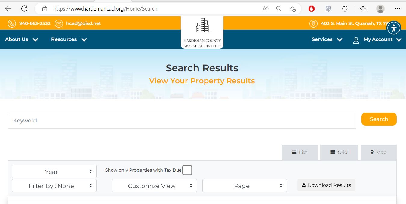
Use the Hardeman CAD screenshot to filter and download results
The useful official search screenshot from the existing article remains. It shows the results-page controls that appear after a search has been submitted.
Understand the fields shown in a Hardeman CAD result
| Field | What it helps identify | What it does not establish | Best next action |
|---|---|---|---|
| Parcel or property ID | The appraisal account used for values, exemptions, special appraisal and protests. | The County Clerk document number or payment confirmation. | Save it before contacting CAD or the Tax Office. |
| Account number | The account used in appraisal and collection systems. | That every related surface, mineral or business interest is included. | Search all relevant property types. |
| Owner name | The owner currently displayed for appraisal administration. | Complete title, probate ownership, lien priority or mineral ownership. | Verify the recorded documents. |
| Property address | The physical or assigned situs location. | The exact boundary, acreage, easement or access rights. | Compare the legal description, map and survey. |
| Legal, abstract or subdivision | The survey, abstract, tract, lot, block or subdivision attached to the account. | That the abbreviated CAD description is complete enough for a legal instrument. | Match it with the deed or recorded plat. |
| Lease name or number | A mineral or related property account. | Current mineral title, royalty ownership or lease validity. | Review recorded mineral documents and division records. |
| Acres | The acreage maintained for appraisal purposes. | The exact surveyed or legally conveyed acreage. | Use the deed and licensed survey. |
| Market value | The district’s January 1 estimate of open-market value. | The purchase price, lender value or final tax amount. | Review appraisal evidence and comparable property. |
| Property type or category | Residential, ranch, commercial, mineral, utility or personal-property treatment. | That every characteristic or actual use is correct. | Document a category or property-data error. |
| Base tax due | A base unpaid amount displayed for the selected account and year. | The current payoff including penalty, interest or collection charges. | Confirm the balance with the Tax Office. |
Useful category examples in the official search
Single-family residential or residential mobile-home property.
Ranchland or ranchland with improvements.
Farm-and-ranch improvements or a rural mobile home on owned land.
Mineral real property.
Water, gas, electric, telephone, railroad, pipeline or cable property.
Commercial or industrial tangible personal property.
Mobile homes or travel trailers maintained as personal property.
Exempt or specially coded property categories.
Fix common Hardeman CAD search problems
| Problem | Likely reason | What to try next |
|---|---|---|
| Full owner name returns nothing | The account may use surname-first order, initials, a spouse, trust, estate or former owner. | Search the surname or main entity word alone. |
| Rural address returns nothing | The property may be indexed by owner, legal description, abstract, survey or geographic ID. | Use By Property, Advanced Search and the map. |
| One owner has many results | The owner may hold a residence, ranch, mineral account, mobile home or business assets. | Compare property type, parcel ID and legal description. |
| Mineral property is missing | The mineral account may use a lease, estate, operator, company or different owner. | Select Mineral and search lease and owner variations. |
| Business equipment is not with the building | Equipment and inventory normally use a separate Personal Property account. | Search the business name, DBA, owner and location. |
| Recent buyer is not displayed | Deed recording and appraisal ownership maintenance are separate processes. | Confirm the deed with the Clerk and contact CAD. |
| Only properties with tax due appear | The tax-due filter may still be selected. | Clear “Show only Properties with Tax Due” for a general search. |
| CAD and tax years differ | The appraisal portal includes 2026 while the tax portal currently starts with billed 2025 accounts. | Match the year before comparing values or balances. |
Use the Hardeman CAD map without treating it as a survey
Follow a Hardeman County value from January 1 to the tax bill
The district determines market value and administers exemptions and special valuations.
The county, cities, school districts, hospitals and groundwater district adopt their own rates.
The Tax Office or another listed collector applies certified values and adopted rates.
2025 rates currently published by the Hardeman County Tax Office
| Taxing entity | Published 2025 rate | What to check for 2026 |
|---|---|---|
| Hardeman County | $0.688800 | Confirm the final county rate and the exact property jurisdictions. |
| Chillicothe Hospital District | $0.470000 | Confirm that the property lies within this hospital district. |
| Hardeman Hospital District | $0.274400 | Confirm district placement and the adopted rate. |
| Gateway Groundwater Conservation District | $0.010000 | Review the current groundwater-district rate. |
Use current Hardeman CAD forms and retain proof of delivery
Document the qualifying use of Hardeman County farm and ranch land
Agricultural appraisal is based on qualifying use and local intensity—not merely rural ownership, acreage or the presence of livestock. The land’s primary use must be agricultural when it serves more than one purpose.
Separate taxable business assets from the real-estate account
Search beyond the surface real-estate account
Hardeman CAD states that real estate and personal property are appraised locally. Mineral, utility and industrial accounts are appraised for the district by Pritchard & Abbott, Inc. in Amarillo.
Select Mineral Property and search the owner, property ID, geographic ID, lease name, lease number or legal description.
Water, gas, electric, telephone, railroad, pipeline and cable accounts use specialised category codes.
Use the exact account and notice because the appraisal may involve the district’s contracted appraisal firm.
Build a Hardeman CAD protest around a specific appraisal issue
Evidence checklist by issue
Use condition, size, age, quality, improvements and relevant sales or unequal-appraisal accounts.
Use acreage, access, soil, water, improvements, use history and relevant rural comparisons.
Use ownership documents, leases, production information, asset schedules, cost records and account-specific evidence.
Move from the CAD account to the correct Hardeman County tax bill
Jan Evans
Hardeman County Courthouse300 S. Main Street
Quanah, Texas 79252
Mailing: P.O. Box 30, Quanah, TX 79252-0030
940-663-5221
Fax: 940-663-2770
hardemantax@co.hardeman.tx.us
Hours: Monday–Friday, 8:00 AM–4:30 PM, excluding holidays.
Vehicle title transfers stop after 4:00 PM.
Use the Hardeman County Clerk when the CAD owner display is not enough
The Hardeman County Clerk’s online system provides document, party and Advanced Search tools. The county states that online coverage runs from October 31, 2006 forward. Earlier records remain in the books at the Clerk’s office.
Deborah Akers
Hardeman County Courthouse300 S. Main Street
Quanah, Texas 79252
Mailing: P.O. Box 30, Quanah, TX 79252-0030
940-663-2901
Fax: 940-663-5161
Online-system hours: Public records are available online 24 hours a day.
Monday–Friday, 8:00 AM–5:00 PM, except county holidays.
The online public-record system reported records updated through April 17, 2026 when reviewed.
What to check after acquiring Hardeman County property
Use the search method that fits the Hardeman County property
Search the street address, verify City of Quanah and Quanah ISD and check the homestead and tax accounts separately.
Confirm City of Chillicothe, Chillicothe ISD, hospital-district treatment and the collector shown on each statement.
Hardeman CAD includes some property connected with Childress ISD. Verify the county, school boundary and collector.
Use owner, legal description, abstract, acreage and map rather than relying only on a mailing address.
Search historical owner names, survey, abstract, road information and adjoining parcels.
Separate market value from productivity value and document qualifying agricultural use for each account.
Select Mineral Property and compare lease and account information with recorded deeds and assignments.
Search both the real-estate account and the Personal Property account for equipment and inventory.
Check older Clerk books, current online records, prior-owner CAD accounts, exemptions, minerals and taxes due.
Contact the Hardeman County office that maintains the record
Use for property search, values, exemptions, agricultural appraisal, maps, renditions, account PINs and protests.
403 S. Main StreetQuanah, Texas 79252-4017
Mailing: P.O. Box 388, Quanah, TX 79252-0388
940-663-2532
Fax: 940-663-6490
hcad@qisd.net
Comptroller directory: Richard Petree, Interim Chief Appraiser.
CAD contact page: Avery Fuqua, Deputy Chief Appraiser.
Hours: Not published on the current official contact page; call before visiting.
Use for bills, current payoffs, authorised payments, receipts and collection questions.
300 S. Main StreetQuanah, Texas 79252
Mailing: P.O. Box 30, Quanah, TX 79252-0030
940-663-5221
Fax: 940-663-2770
hardemantax@co.hardeman.tx.us
Tax Assessor-Collector: Jan Evans
Hours: Monday–Friday, 8:00 AM–4:30 PM.
Use for deeds, mortgages, liens, mineral documents, older record books and document copies.
Hardeman County Courthouse300 S. Main Street
Quanah, Texas 79252
Mailing: P.O. Box 30, Quanah, TX 79252-0030
940-663-2901
Fax: 940-663-5161
County/District Clerk: Deborah Akers
Hours: Monday–Friday, 8:00 AM–5:00 PM.
Recheck holiday closures, staff availability, payment methods, identification requirements and whether the task can be completed online.
Take the parcel ID, account, owner, legal description, appraisal notice, tax year and any filing or payment confirmation.
Open the exact Hardeman County property resource you need
Search real estate, personal property and mineral accounts using basic and advanced criteria.
Open property searchFilter by year, tax due, property type, account or owner and download the displayed results.
Open search resultsResearch approximate parcel location, adjoining accounts, abstracts and rural land.
Open interactive mapDownload homestead, veteran, rendition, agricultural and electronic-delivery forms.
Open Hardeman CAD formsRegister, sign in and manage an eligible appraisal protest.
Open online protestRequest the unique online-account PIN associated with a property.
Request a property PINSearch past hearings, future hearings and open protest records.
Search hearingsReview rates, depreciation schedules, annual reports, reappraisal plans and certified rolls.
Open data and reportsFind a billed account, verify the balance and continue to the authorised processor.
Open Hardeman County tax searchHow this Hardeman County guide was rebuilt

The Hardeman CAD search screenshot is now connected to exact year, tax-due, view and download instructions. The existing editorial image remains with transparent information about the article’s official-source review.
Outdated chief-appraiser information, the third-party map recommendation, unverified CAD office hours and generic tax-calculator sections were replaced with current official search, form, protest, tax and County Clerk workflows.
Last official-source review: July 28, 2026. Values, tax balances, forms, rates, officials, office hours, fees and portal functions can change after publication.
Hardeman County Appraisal District FAQs
What is the official Hardeman County Appraisal District website?
The official website is hardemancad.org. It provides property search, forms, the interactive map, online protest access, hearing searches, appraisal reports and district contacts.
How do I search Hardeman County property records?
Use the official CAD homepage or Search Results page. Search by owner, property ID, account or address, or use geographic ID, legal description, abstract, subdivision, lease, acreage or category fields.
What should I click in the Hardeman CAD search screenshot?
Use the keyword box for a quick search, select the correct year, use the tax-due filter only for an unpaid account and switch between List, Grid and Map. Download Results saves the displayed search list.
Why can I not find rural Hardeman County land by address?
Rural property may be indexed by owner, property ID, geographic ID, abstract, survey, tract, legal description or acreage. Use By Property or Advanced Search and compare the interactive map.
Can I search Hardeman County mineral property separately?
Yes. Select Mineral Property and search by owner, property ID, geographic ID, lease name, lease number or legal description. Mineral and surface accounts can be separate.
Does Hardeman CAD collect property taxes?
Hardeman CAD determines appraisal values and administers exemptions and special valuations. The Hardeman County Tax Assessor-Collector handles bills, payments and receipts for the entities collected by that office.
How do I pay Hardeman County property taxes online?
Search the account at hardemancountytax.org, verify the year and amount and use the county-authorised Certified Payments link. You must know the amount, account number and name on the account. A convenience fee applies.
How do I apply for a Hardeman County homestead exemption?
Download the current residence application from the Hardeman CAD forms page. Include the applicant’s driver licence or other required information, retain filing proof and verify the exemption later.
What are the Hardeman CAD rendition, agricultural and protest deadlines?
Most renditions are due April 15, with a May 15 extension after a timely written request. Many exemption and 1-d-1 applications are due April 30. Most protests are due May 15 or 30 days after the appraisal notice is mailed, whichever is later.
Where can I search Hardeman County deeds and liens?
Use the Hardeman County Public Records system. Online records cover October 31, 2006 forward. Earlier records remain available in the County Clerk’s books at the courthouse.