Track a Franklin County Parcel From the Mount Vernon Search to the Correct Official Record
Start with Franklin County Appraisal District when you need a Property ID, appraisal owner, legal description, acreage, market value, exemption, productivity value, mineral-account route, GIS parcel or protest information.
Continue to the Franklin County Tax Assessor-Collector for bills and payments, the County Clerk for deeds and liens, the Septic Inspector for on-site sewage permits, or the Franklin County Water District for Lake Cypress Springs leases and development rules.
Use the Property ID or geographic ID whenever one is available.
310 W. Main Street, Mount Vernon, Texas 75457.
204 Texas Highway 37, Mount Vernon, Texas 75457.
Mineral, utility and industrial accounts use specialist appraisal.
Local portals and procedures reviewed July 31, 2026.
What do you need from the Franklin County property record?
Use Basic, Owner, Property, All Criteria or Advanced Search, then verify the legal description.
Follow the search workflowConfirm the property, tax year, live balance and payment receipt.
Review payment stepsCreate a Franklin CAD account before requesting the unique property PIN.
Review account stepsMarket, appraised, productivity and taxable values answer different questions.
Understand the value recordSearch documents back to 1843 instead of treating the CAD owner field as legal-title proof.
Search recorded property documentsReview lake rules, septic, plats, flood hazards, access, utilities and title records.
Use the due-diligence checklistSearch Franklin County property records without choosing the wrong parcel
Use the Franklin CAD screenshot to choose the correct search tab
The official-site screenshot from the existing article is preserved below. It shows the five search paths available from the Franklin CAD property-search page.
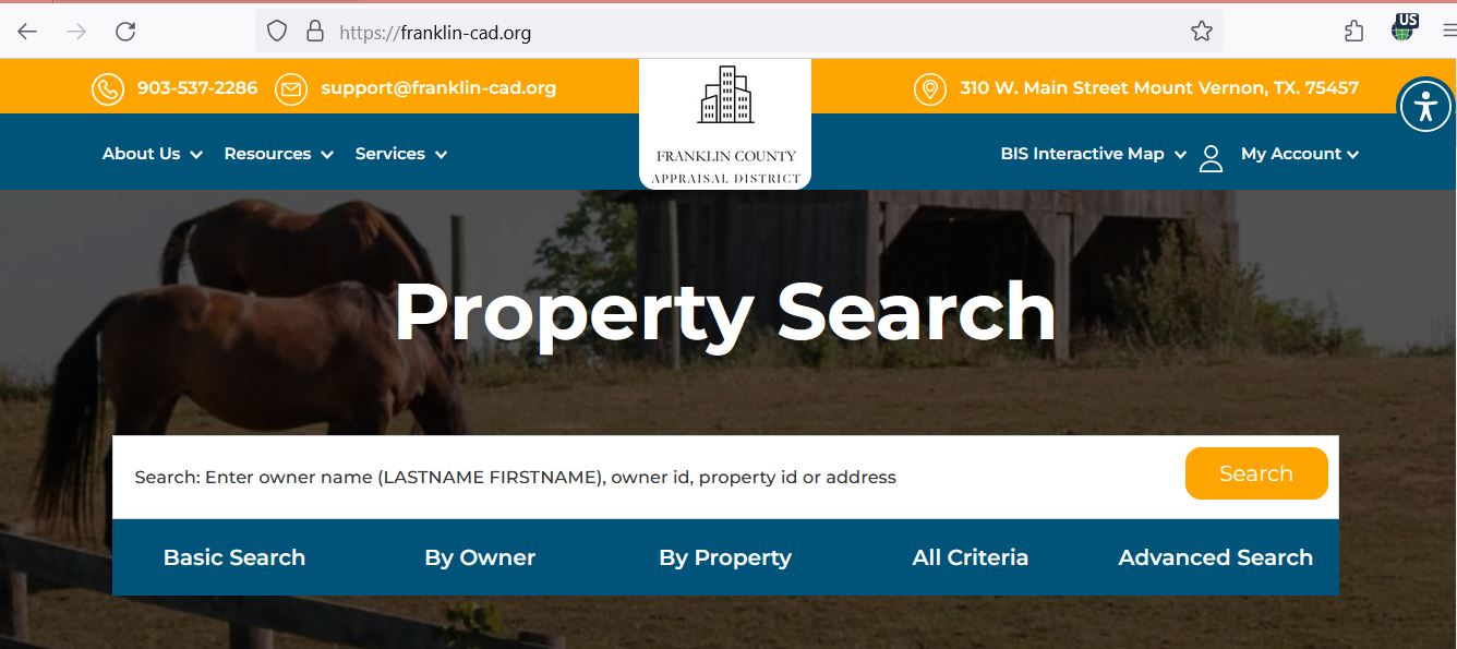
Choose the Franklin CAD search field that matches the information you have
| Search field | Best use | Practical tip |
|---|---|---|
| Property ID | Open an exact account from a notice, bill or saved property record. | Confirm owner and tax year after opening it. |
| Owner name | Find property held by a person, estate, trust, company or family member. | Enter the last name first and try fewer words when necessary. |
| Owner ID | Find accounts linked to one appraisal-system owner. | Review every result because one owner may hold multiple parcels. |
| Geographic ID | Match a parcel to a geographic or legal-reference identifier. | Do not treat it as a legal boundary. |
| Street name | Find a property when a complete address returns nothing. | Remove the house number, direction, city and suffix. |
| Legal description | Search rural, inherited or recently divided land. | Enter a distinctive portion rather than the entire description. |
| Abstract | Locate survey-based acreage without a dependable situs address. | Compare abstract, tract, acreage and GIS location. |
| Subdivision | Find a lot in a platted development or lake subdivision. | Match lot, block, phase and recorded plat. |
| Lease name or number | Locate mineral, industrial or lease-related appraisal accounts. | Surface land and mineral interests may use separate records. |
| Acreage or value filter | Research groups of properties in Advanced Search. | Use the filter for research—not as proof that every result is comparable. |
Understand what each Franklin CAD account field does and does not prove
| Field | What it identifies | What it does not prove | Best next action |
|---|---|---|---|
| Property ID | The appraisal account used by Franklin CAD. | That every other office uses the same identifier. | Save it before calling, filing or paying. |
| Geographic ID | A mapping or geographic reference. | A surveyed boundary, access right or exact acreage. | Compare deed, plat, GIS and survey records. |
| Owner shown | The owner carried for appraisal administration. | Complete legal title, heirship or lien status. | Search County Clerk records. |
| Situs address | The physical location carried by the appraisal district. | Legal access, mailing address or complete legal description. | Compare the map and recorded documents. |
| Legal description | An abbreviated tract, lot, block, abstract or subdivision reference. | That the abbreviated text is adequate for a deed. | Open the recorded instrument or plat. |
| Acreage | The acreage carried for appraisal purposes. | Surveyed or legally guaranteed acreage. | Verify through a deed and professional survey. |
| Market value | Franklin CAD’s opinion of market value as of January 1. | A sale price, insurance value or final tax bill. | Compare property facts, sales and condition evidence. |
| Productivity value | Special-use value for qualifying agricultural, wildlife or timber land. | Continued qualification after a sale or change of use. | Confirm the qualifying acreage and current application status. |
| Taxable value | Value after applicable exemptions for a taxing unit. | The live balance, payment status or receipt. | Open the Franklin County Tax Office account. |
| Taxing units | The county, city, school and special districts connected to the account. | That each unit uses the same exemption or collector. | Review every taxing-unit line independently. |
Use Franklin CAD’s interactive map without treating parcel lines as a survey
Register, request a Franklin CAD PIN and manage electronic communication
Separate Franklin CAD appraisal value from the final property-tax bill
Franklin CAD’s opinion of what the property would sell for under normal market conditions as of January 1.
The value after an applicable appraisal limitation or qualifying special-use appraisal.
Exemptions reduce taxable value; adopted rates and the collection ledger determine the bill.
Franklin County property-office router
Choose the task that matches your question. The tool directs you to the most useful official starting point and does not transmit your information.
Fix common Franklin CAD and Tax Office search problems
| Problem | Likely reason | Practical fix |
|---|---|---|
| Owner name returns nothing | The account may use initials, a spouse, estate, trust or business name. | Search the last name alone and try alternate ownership names. |
| Full address fails | The appraisal record may contain a shortened or incomplete physical address. | Search only the street name, then use the owner or Property ID. |
| Rural tract has no normal address | The property may be indexed by abstract, subdivision, legal description or geographic ID. | Use By Property, All Criteria or the GIS map. |
| Lake property is difficult to identify | The parcel, subdivision lot and Water District lease may use different references. | Compare Property ID, subdivision, deed, plat and FCWD records. |
| Recently purchased property shows the seller | The recorded deed may still be processing into the appraisal system. | Confirm the instrument with the County Clerk and provide it to CAD. |
| Mineral account is missing | Mineral interests can be separate from the surface-real-estate account. | Search lease name or number and contact CAD about Pritchard & Abbott records. |
| Expected exemption is missing | The application may be pending, incomplete, filed for another year or denied. | Check the tax year and contact CAD with filing proof. |
| Tax portal shows a different amount | The collection ledger may include penalties, interest, credits or later payments. | Use the Tax Office amount as the live collection balance. |
| PIN request does not work | The account or ownership information may not match the district record. | Verify the owner and Property ID, then contact support@franklin-cad.org. |
Verify Franklin County exemptions on the complete property account
Confirm the home is the applicant’s principal residence and the benefit appears for the correct year.
Review the additional exemption, school-tax ceiling and possible payment or deferral options.
Check qualification documents, additional exemption and applicable tax ceiling.
Use the correct veteran application and attach the required VA documentation.
Inherited ownership may require affidavits or other evidence when conventional title is incomplete.
Charitable, religious, cemetery, disaster and other property may qualify under specific requirements.
Prepare these documents
Review Franklin County special appraisal under qualifying-use rules
Agricultural, wildlife and timber appraisal is based on qualifying use and productivity—not simply owning acreage. A qualified account can display both market value and a lower productivity value.
Prepare evidence showing the type, duration and intensity of qualifying land use.
The operation should meet a level of agricultural activity typical for the area.
Review both market and productivity values in the land section.
Prepare the management plan, annual report and evidence of approved practices.
Use the timberland or restricted-use timberland application that matches the property.
Do not assume that the seller’s special appraisal automatically continues after closing.
Keep signed leases, livestock records, receipts, photographs and management records.
Ask CAD about rollback consequences before changing qualified land.
Compare the qualifying acreage with the deed, GIS map and land-account details.
Use the correct Franklin CAD route for special-property records
Review furniture, equipment, machinery, inventory, vehicles and other income-producing assets.
Franklin CAD publishes business-personal-property and general-real-property rendition forms.
Heavy-equipment dealers use specialised inventory declarations and monthly tax statements.
Mineral interests may use lease names or numbers and can be separate from surface land.
Mineral, utility and industrial accounts are appraised for Franklin CAD by Pritchard & Abbott.
Use County Clerk oil-and-gas lease and property records when legal mineral ownership matters.
Identify the Franklin County appraisal issue before choosing a filing route
Build a Franklin County protest file around one clear issue
Use properties with similar use, size, age, quality, condition and location.
Compare appropriately adjusted appraisal values—not unrelated listings.
Use dated photographs, repair estimates and inspection reports.
Document access, flood hazard, easements, topography, utility and septic constraints.
Prove incorrect square footage, building class, condition, outbuildings or acreage.
Use land-use history, leases, livestock, crop, wildlife or timber records.
Use purchase, disposal, inventory, depreciation and location records.
Mark incorrect characteristics, dissimilar sales and unsupported adjustments.
State the value or correction requested and connect each exhibit to it.
Pay Franklin County property taxes through the official Tax Office system
Use the drop box in front of the Tax Office and include a current mailing address for the receipt.
Mail property-tax payments to P.O. Box 70, Mount Vernon, Texas 75457.
Review the official quarterly-payment schedule when the account qualifies.
Search Franklin County deeds, liens, oil-and-gas leases and releases
Prepare the correct Franklin County recording or copy fee
| Service | Published amount | Practical note |
|---|---|---|
| Real-property recording | $25 first page | Additional indexing or document penalties may apply. |
| Additional recording page | $4 per page | A page includes any page or part containing visible marks. |
| Additional indexed name | $0.25 after five names | Ask the Clerk to calculate the total before filing. |
| Certified copy | $1 per page plus $5 certification | Specify the instrument number and required copy type. |
| Noncertified copy | $1 per page | Online printing requires account registration and payment. |
| Standard replat recording | $31 | New plats have additional requirements and fees. |
| New-plat additional fee | $100 | Franklin County does not accept two-page plats. |
| Credit/debit convenience fee | Greater of $2 or 2.85% | American Express and phone card payments are not accepted. |
Check Franklin County septic requirements before buying or building
Check Franklin County Water District records before changing a lake property
A CAD parcel, deed and Water District lease can describe different legal interests.
Check development, replat, environmental, dock and on-water-facility requirements.
Open FCWD RulesWater District lease or service charges are not the same as county property taxes.
Use surveys, lease documents, recorded easements and district records.
Lake projects may involve FCWD and, in some situations, U.S. Army Corps of Engineers review.
FCWD rules include restrictions affecting short-term rental of leased property.
Complete these checks before buying or improving Franklin County property
Match Property ID, geographic ID, deed, legal description, GIS location and acreage.
Check current and delinquent balances, payment history and quarterly-payment status.
Review recorded instruments and obtain professional title work when transaction risk matters.
The seller’s homestead exemption, cap and tax ceiling may not transfer.
Franklin County property can involve Mount Vernon, Winnsboro, Rivercrest, Saltillo or Sulphur Bluff ISD.
Confirm whether agricultural, wildlife or timber qualification will continue.
Verify permits, design, maintenance needs and replacement-area availability.
Use FEMA mapping, local hazard plans, site inspection and insurance guidance.
Land division or replatting can require County Clerk and Commissioner’s Court action.
Surface ownership does not prove ownership of every mineral interest.
Lake Cypress Springs property may involve FCWD leases, construction standards and water-related permits.
Review Franklin County’s hazard-mitigation plan and current emergency-management information.
Use Franklin CAD reports for research beyond one property account
Review appraisal cycles, field-card practices, deed updates and GIS maintenance.
Review district workload, notices, protests, appraisal methods and ARB responsibilities.
The district currently displays 2025 rates; use 2026 transparency updates when available.
Use broader data for research while verifying important conclusions against the live account.
Review available hearing information while treating the individual notice as controlling.
Use official news and meeting notices for district governance and public-comment information.
Important Franklin County appraisal and payment dates
Franklin County appraisal, tax, deed, septic and hazard offices
Mount Vernon, Texas 75457
Mailing: P.O. Box 720, Mount Vernon, Texas 75457-0720
Phone: (903) 537-2286
Fax: (903) 537-2812
Email: support@franklin-cad.org
Hours: Monday-Thursday 8:00 AM-4:30 PM; Friday 8:00 AM-12:00 PM.
Chief Appraiser: Russell McCurdy, RPA, RTA, CCA, CTA
Mount Vernon, Texas 75457
Mailing: P.O. Box 70, Mount Vernon, Texas 75457
Property tax: (903) 537-2358
Vehicle registration: (903) 537-4383
Fax: (903) 537-3483
Tax Assessor-Collector: Melissa McSwain Clawson
Hours: Monday-Thursday 8:00 AM-4:45 PM, closed 11:30 AM-12:30 PM; Friday 8:00 AM-4:00 PM, open through lunch.
Mount Vernon, Texas 75457
Phone: (903) 537-8357
Fax: (903) 537-2962
Email: countyclerk@co.franklin.tx.us
County Clerk: Brook Bussell
Hours: Monday-Thursday 8:15 AM-12:00 PM and 1:00 PM-4:30 PM; Friday 8:15 AM-3:30 PM.
Mount Vernon, Texas 75457
Phone: (903) 537-8346
Fax: (903) 537-2632
Designated Representative: Max Cannaday
Administrative Assistant: Jennifer Cooper
Mount Vernon, Texas 75457
Phone: (903) 537-4539
Use for county hazard-mitigation planning and emergency-management information.
Use for Lake Cypress Springs district leases, bills, development standards, dock or on-water-facility rules and environmental requirements.
Open Franklin County Water DistrictOfficial Franklin County property resources
Property search, current notices, contacts and appraisal information.
Open Franklin CADReview approximate parcel location and surrounding appraisal records.
Open GIS mapCreate an online account before requesting a property PIN.
Register onlineRequest the unique PIN connected to the Franklin CAD property account.
Request PINUse the official appeal route and preserve the filing confirmation.
Open online protestDownload exemption, agricultural, wildlife, timber, protest and rendition forms.
Open formsSearch accounts, pay taxes, print receipts and review balances.
Open Tax Office portalReview office hours, recording information, fees and property records.
Open County ClerkSearch deeds, liens, contracts, leases and releases.
Open Clerk record searchReview Commissioner’s Court readings, signatures, advertising and recording requirements.
Open plat proceduresFind the application, checklist, rules and current permit fees.
Open septic informationReview Lake Cypress Springs rules, leases, bills and development requirements.
Open Water DistrictReview county-level hazard risks and mitigation planning.
Open hazard planCross-check CAD contacts, active taxing units and collection responsibilities.
Open Franklin County directorySearch official flood-hazard maps before buying or developing property.
Open FEMA Map Service CenterHow this Franklin County guide was rebuilt and verified

Independent review of appraisal, collection, deed, septic and lake-property systems
This rebuild preserves the images from the existing article while replacing its short overview with complete property-search, screenshot, PIN, electronic-notice, exemption, agricultural, protest, tax-payment, deed, mineral, septic and Lake Cypress Springs workflows.
Official resources reviewed include Franklin County Appraisal District, Franklin County Tax Assessor-Collector, Franklin County Clerk, Franklin County Septic Inspector, Franklin County Water District, Franklin County Emergency Management and the Texas Comptroller.
AppraisalDistrict.org is an independent informational website and is not operated by Franklin County Appraisal District, Franklin County, Franklin County Water District or any Texas government agency.
10 common Franklin County appraisal and property-tax questions
1. What is the official Franklin County Appraisal District website?
The official website is franklin-cad.org. Use it for property search, maps, account registration, PIN requests, forms, protests and district contact information.
2. How do I search Franklin County property records?
Open Franklin CAD’s official website and choose Basic Search, By Owner, By Property, All Criteria or Advanced Search. Use the Property ID when available, or search by owner, address, geographic ID, legal description, abstract, subdivision or lease.
3. Why does my Franklin CAD address search show no result?
The account may use a shortened street name, different direction, rural description or incomplete situs address. Search only the street name, then try owner, Property ID, geographic ID, abstract, subdivision or GIS map.
4. Does Franklin County Appraisal District collect property taxes?
No. Franklin CAD appraises property and handles exemptions and protests. Franklin County Tax Assessor-Collector handles payments, balances, receipts, penalties and quarterly-payment questions.
5. How do I pay Franklin County property taxes online?
Open the official Franklin County Tax Office portal, search and verify the account, review the year and balance, complete the payment and save the receipt.
6. What was the Franklin County protest deadline for 2026?
Most protests were due by May 15 or the 30th day after the appraisal notice was delivered, whichever was later. The individual notice controls. As of July 31, contact Franklin CAD immediately about any limited late-protest or correction option.
7. How do I obtain a Franklin CAD online account PIN?
Create or sign in to a Franklin CAD account, open the Request a PIN page and enter the property and ownership details requested.
8. Can Franklin CAD maps or acreage be used as a legal survey?
No. The appraisal record and GIS map are research tools. Verify legal descriptions, acreage, access and boundaries through deeds, plats, title records and a professional survey.
9. Where can I search Franklin County deeds and liens?
Use the official County Clerk Records Public Access portal. Deeds are indexed and imaged from 1843 forward, while contract, lien and oil-and-gas lease records are available from 1910 forward.
10. Where is Franklin County Appraisal District located?
Franklin CAD is at 310 W. Main Street, Mount Vernon, Texas 75457. Its mailing address is P.O. Box 720, Mount Vernon, Texas 75457-0720, and its phone number is (903) 537-2286.