Trace an Anderson County Parcel From East Texas Map to the Right Official Record
Start with Anderson County Appraisal District when you need the appraisal account, property ID, geographic ID, owner shown for appraisal purposes, property address, legal description, land acreage, improvements, value, exemption or appraisal history.
Then move to the office that controls your next task. The Anderson County Tax Assessor-Collector handles tax bills, balances, payments and receipts, while the County Clerk maintains deeds, liens, easements, plats and other recorded property documents.
801 N. Perry St., Palestine.
903-723-2949.
Quintin Baack.
703 N. Mallard, Suite 104.
500 N. Church, Room 10.
Sources checked July 28, 2026.
What are you trying to complete in Anderson County?
Use the account number, owner, address, property ID, geographic ID or legal description.
Follow the official search stepsCompare land, improvements, market value, appraised value, taxable value and exemptions.
Understand the value fieldsVerify the property, tax year, balance, payment method, fee and receipt.
Follow the payment workflowIdentify the exact value, property-detail, exemption or special-appraisal issue.
Build a focused protestReview qualifying use, acreage, production history, category and supporting records.
Prepare a land applicationUse the recorded instrument instead of treating the CAD owner field as proof of title.
Search official recordsSearch Anderson County property records without opening the wrong account
Use the Anderson CAD screenshot as a property-search guide
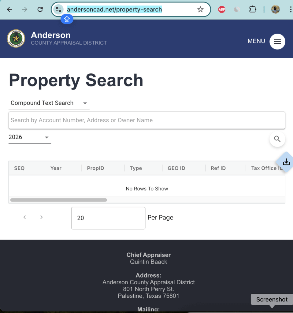
What to click and verify
Use Anderson CAD map search for rural, timber and acreage property
Map search is useful when a normal address does not identify the correct parcel. It can help distinguish county-road acreage, timber tracts, adjoining lots, manufactured-home accounts and parcels near a city or school-district boundary.
Understand what the Anderson CAD property record tells you
| Field | What it identifies | What it does not prove | Next action |
|---|---|---|---|
| PropID or account number | The appraisal account used in Anderson CAD records. | That every outside database uses the identical number. | Save it for CAD, tax, exemption and protest questions. |
| GEO ID | A geographic identifier connected with the parcel and mapping system. | A surveyed boundary or guaranteed acreage. | Compare the map, deed and survey. |
| Owner shown | The owner entry maintained for appraisal administration. | Clear title, complete heirship or absence of liens. | Search County Clerk official records. |
| Situs address | The property location carried in the CAD account. | The owner mailing address or complete legal description. | Compare it with the map and legal record. |
| Legal description | The lot, block, subdivision, abstract, survey or tract reference used by CAD. | That the shortened CAD description is suitable for a deed. | Open the recorded deed or plat. |
| Market value | CAD’s opinion of market value as of January 1 for the appraisal year. | A guaranteed selling price or final tax bill. | Review sales, condition and equal-appraisal evidence. |
| Appraised value | The value after an applicable appraisal limitation or special appraisal. | The final taxable value for every taxing unit. | Continue to exemption and taxable-value information. |
| Taxable value | The value remaining after applicable exemptions for a taxing unit. | The live amount due, penalties or payment status. | Use the Tax Office ledger. |
| Land and improvements | How CAD describes and values land, buildings and other improvements. | That every area, condition item or use classification is accurate. | Document incorrect data before requesting review. |
| Taxing units | The county, school, city and college jurisdictions attached to the account. | That every unit uses the same collector. | Follow the collector printed on each statement. |
Separate market value, appraised value and taxable value
CAD’s opinion of what the property would sell for under normal market conditions as of January 1.
The value after an applicable homestead limitation, non-homestead limitation or special appraisal.
The value remaining after applicable exemptions for each taxing unit.
Read the Notice of Appraised Value before deciding whether to protest
Confirm the account number, owner, mailing address, situs address and legal description.
Compare prior and proposed land, improvement, market and appraised values.
Check acreage, square footage, year built, class, condition, use and listed improvements.
Confirm homestead, age, disability, veteran and special-appraisal information.
Use the date printed on the individual notice rather than assuming every property has the same date.
Treat estimates as preliminary until local rates are adopted and the Tax Office issues the bill.
Fix a missing or incorrect Anderson County property result
| Problem | Likely reason | Practical fix |
|---|---|---|
| Owner name returns nothing | The account may use initials, a spouse, estate, trust, company or different spelling. | Search the surname only or use the account number. |
| Address search fails | The situs address may differ from the postal or mailing format. | Use the street number and main road name only. |
| County-road property is missing | The road may be abbreviated or the account may use a legal description. | Try CR, County Road, FM, property ID, owner or legal description. |
| Timber or agricultural tract is not found | The parcel may have no standard address or may be divided into several accounts. | Search the owner, property ID, Geo ID, abstract or map. |
| Recently purchased property shows the seller | The deed may not yet have completed processing into the CAD system. | Confirm County Clerk recording and save the instrument details. |
| Inherited property shows an estate | CAD may not have sufficient probate, heirship or deed documentation. | Ask CAD which ownership documents are required. |
| Map acreage looks wrong | CAD mapping is maintained for appraisal rather than legal surveying. | Compare the recorded deed, plat and professional survey. |
| Tax bill differs from CAD value | Exemptions, tax rates, ceilings, penalties and payments affect the collection record. | Match the tax year and contact the Tax Office. |
Anderson County search tips for homes, acreage and specialised property
Check city status, school district, TVCC unit, homestead exemption and every adjoining lot or separate account.
A Palestine mailing address does not automatically prove City of Palestine or Palestine ISD taxation.
Confirm the city, school district, college district, county boundary and collecting office.
Review legal access, road frontage, agricultural use, timber, acreage and survey information separately.
Check land-use history, intensity, leases, livestock or crop records and the homesite portion.
Wooded acreage does not automatically qualify. Review timber-management history, category and productivity value.
Search for the land and home separately when ownership or appraisal accounts differ.
Surface and mineral ownership can follow different records and may create multiple appraisal accounts.
Review the real estate and business personal property accounts rather than relying only on the building record.
Use Anderson CAD, the Tax Office or County Clerk correctly
| Your question | Correct starting point | What to prepare |
|---|---|---|
| Why did my appraisal increase? | Anderson CAD | Account, notice, tax year and evidence. |
| Why is an exemption missing? | Anderson CAD | Application, ID, qualification date and proof of filing. |
| Does my land qualify for ag or timber appraisal? | Anderson CAD | Use history, acreage, leases, maps and production records. |
| How much tax is due? | Collector shown on the tax statement | Tax account, year, owner and taxing unit. |
| Did my payment post? | Anderson County Tax Assessor-Collector | Receipt, confirmation number, amount and year. |
| Who legally owns the property? | County Clerk or title professional | Grantor, grantee, legal description and recording period. |
| Where can I obtain a deed or lien? | Anderson County Clerk | Names, instrument date and document type. |
| Is the CAD boundary legally correct? | Surveyor, County Clerk and title professional | Deed, plat, survey and CAD map. |
| Who sets the tax rate? | Each local taxing unit | Taxing-unit list and Truth-in-Taxation information. |
Correct the office or system that owns the inaccurate field
Apply for and verify Anderson County property exemptions
Confirm principal-residence use, ownership, identification and the property account before submitting the application.
Review the additional exemption, school-tax ceiling and possible instalment or deferral options.
Prepare the required disability evidence and confirm the exemption for every relevant taxing unit.
Use the correct veteran form and attach the required VA documentation for the claimed category.
Ask which heirship affidavit, deed, probate document or ownership information is needed.
Use the correct charitable, religious, school or other organisation-specific application.
Homestead filing micro-steps
Prepare agricultural, timber or wildlife appraisal applications
Special appraisal is based on qualifying use and history. Owning acreage, cattle or trees does not automatically qualify every acre.
| Land situation | Starting route | Evidence to organise |
|---|---|---|
| Crop, hay or livestock use | 1-d-1 open-space agricultural appraisal | Use history, acreage, leases, livestock or crop records, maps and photographs. |
| Timber production | Timberland appraisal application | Forest-management history, stand information, harvests, reforestation, maps and ownership records. |
| Wildlife management | Wildlife-management plan and supporting report | Prior qualification, management plan, qualifying activities, logs, invoices, maps and photographs. |
| Mixed homesite and acreage | CAD review of qualified and non-qualified portions | Map or survey separating the residence, yard, business and productive land. |
| Planned change of use | CAD consultation before the change | Current qualification, intended use, dates, acreage and supporting documents. |
Search business personal property and mineral accounts separately
Business equipment, furniture, machinery, inventory and other income-producing assets may have a separate account from the land and building.
Mineral ownership can be separate from surface ownership. Search every account and compare owner, lease and property identifiers.
The normal Texas business-personal-property rendition deadline is April 15 unless a valid extension applies.
Land and manufactured-home ownership may appear separately. Search the owner, account and location in more than one way.
Prepare an Anderson CAD protest around one provable issue
Evidence packet that is easy to review
Move from the Anderson CAD account to the official tax ledger
Anderson CAD explains appraisal value and exemptions. The Anderson County Tax Assessor-Collector controls the collected tax balance, payment status, receipt and delinquency information.
| Method | Published instructions | What to save or verify |
|---|---|---|
| Palestine office | Pay at 703 N. Mallard Street, Suite 104. | Account, tax year, accepted payment and receipt. |
| Frankston Annex | Pay at 320 S. Commerce Street in Frankston. | Current hours and property-tax service availability. |
| Night drop | Use the drive-through night-drop bin at the Palestine Annex. | Include identifying payment information and retain proof. |
| Online | Search the owner, open the property and select Pay Taxes. | Property, year, amount, fee and confirmation. |
| Telephone | Call 1-866-539-2020 and use jurisdiction code 9106177. | Confirmation number, amount, fee and tax year. |
| Quarter payments | Eligible over-65 or disability homesteads may use January 31, March 31, May 31 and July 31 instalments after completing the required annual affidavit. | Eligibility, election, remaining balance and timely postmark. |
Use the Anderson County Clerk for deeds, liens and land records
Complete these checks before buying or relying on an Anderson County record
Match the account, property ID, Geo ID, legal description, map location and acreage.
Check current and delinquent balances and save a tax receipt or certificate when needed.
Review deeds, liens, releases and easements and obtain a title examination for a transaction.
Seller exemptions, appraisal caps and tax ceilings may not transfer to a buyer.
A mailing address does not by itself prove city, school or college-district taxation.
Compare CAD acreage, square footage, year built, class, condition and improvements with the real property.
Ask whether agricultural, timber or wildlife qualification will continue after the purchase or use change.
Use a survey and title records for private roads, easements, encroachments and boundary questions.
Keep the deed, survey, title policy, closing statement, tax certificate and exemption confirmation.
Important Anderson County appraisal and property-tax dates
Anderson CAD, Tax Office and County Clerk contacts
Palestine, Texas 75801-2547
Mailing: P.O. Box 279, Palestine, Texas 75802-0279
Phone: 903-723-2949
Fax: 903-723-5990
Email: qbaack@andersoncad.net
Chief Appraiser: Quintin Baack
Published hours: Monday–Friday, 8:00 AM–4:30 PM. Call before travelling.
703 N. Mallard Street, Suite 104
Palestine, Texas 75801
Phone: 903-723-7423
Fax: 903-723-7801
Email: tgcross@co.anderson.tx.us
Tax Assessor-Collector: Tommy G. Cross
Hours: Monday–Friday, 8:00 AM–4:30 PM.
Frankston, Texas 75763
Mailing: P.O. Box 965, Frankston, Texas 75763
Phone: 903-876-2211
Fax: 903-876-2333
Call before travelling to confirm the property-tax service and current office hours.
Palestine, Texas 75801
Phone: 903-723-7402
County Clerk: Mark Staples
Hours: Monday–Friday, 8:00 AM–12:00 PM and 1:00 PM–5:00 PM.
Anderson County property resources
Use the current official district website for notices, appraisal information and service updates.
Open Anderson CADSearch by account number, address or owner and verify the property year and identifiers.
Search appraisal recordsLocate rural, timber, city and county-road parcels and compare neighbouring accounts.
Open CAD mapFind homestead, veteran, agricultural, timber, wildlife, rendition and protest forms.
Open Anderson CAD formsVerify payment options, tax dates, office locations, card fees and instalment information.
Open Tax Assessor-CollectorSearch the collection ledger and confirm the tax year, balance and payment status.
Search property taxesReview document services, older handwritten records, contact details and fees.
Open County ClerkSearch deeds, liens, releases, easements and other recorded property documents.
Search official recordsCross-check the appraisal district, tax collector and taxing-unit information.
Open Comptroller directoryHow this Anderson County guide was improved and reviewed

Independent research with actionable official-portal guidance
This regenerated version preserves the useful property-search and editor images from the existing page while replacing brief guidance with a full search workflow, screenshot instructions, parcel-map help, field decoding, rural property scenarios, exemption preparation, protest evidence, payment verification and deed research.
The review used Anderson County Appraisal District, the Anderson County Tax Assessor-Collector, the Anderson County Clerk and the Texas Comptroller county directory.
AppraisalDistrict.org is an independent informational website and is not operated by Anderson CAD, Anderson County or the Texas Comptroller.
10 common Anderson CAD questions
1. What is the official Anderson County Appraisal District website?
The current official district website is andersoncad.net. Use it instead of older Anderson CAD domains.
2. How do I search Anderson County property records?
Open the official property search, select the correct appraisal year and search by account number, owner name or address. Confirm the PropID, GEO ID and legal description before relying on the result.
3. Why does an Anderson CAD address search return no result?
Rural roads and situs addresses may use another format. Try the street number and main road name only, then use the account number, owner surname, property ID, Geo ID or legal description.
4. Does the Anderson CAD owner name prove legal ownership?
No. Use the Anderson County Clerk official records search for deeds, liens, releases and other recorded documents.
5. Does Anderson CAD collect property taxes?
No. Anderson CAD handles appraisal records, values, exemptions and protests. The named tax collector handles the bill, balance, payment and receipt.
6. How can I pay Anderson County property taxes?
Pay at the Palestine or Frankston Tax Office, use the Palestine night drop, pay online or call 1-866-539-2020 with jurisdiction code 9106177. Verify the account and fee first.
7. How do I apply for a homestead exemption?
Download the current application from Anderson CAD, complete the ownership and identification requirements, submit it to the district and keep proof of filing.
8. Does wooded land automatically qualify for timber appraisal?
No. The land must satisfy the applicable use and history requirements. File the correct application and provide timber-management, land-use, map and production evidence.
9. What is the Anderson County protest deadline?
The usual deadline is May 15 or 30 days after the Notice of Appraised Value was mailed, whichever is later. Use the date printed on your individual notice.
10. Where can I search old Anderson County deeds?
Use the County Clerk’s official records system for current indexed documents. The Clerk also publishes handwritten land-record indexes beginning in 1846.