Edwards County Appraisal District CAD and Tax Guide 2026

Edwards County, Texas · Ranches, rural acreage, wildlife management, property taxes and deed records

Navigate an Edwards County Property From Ranch Search to the Right Official Record

Start with Edwards Central Appraisal District when you need a property ID, owner record, geographic ID, abstract, subdivision, legal description, market value, exemption, agricultural valuation, wildlife-management status or protest information.

Rural property often requires more than a street address. Ranches, mobile homes, mineral interests, business assets and separate tracts can appear under different property types or accounts. This guide shows how to find the right account, verify the parcel, submit forms, protest a value, pay taxes and confirm legal ownership.

Property ID Geographic ID Owner name Abstract or subdivision Legal description Tax year
EDWARDS PLATEAU RANCH COMPASS VERIFYING PARCEL
SEARCH → MAP → VERIFY → FILE
The appraisal notice, property record and tax bill serve different purposes. Edwards CAD handles appraisal values, exemptions, agricultural and wildlife-management valuation, property records and protests. The Tax Assessor-Collector handles collection questions and receipts. The County and District Clerk maintains deeds, liens, plats and other recorded legal documents.
Temporary CAD office

A.A.G.B.A. Building, left door, 205 W. Austin, Rocksprings.

Best rural search

Use property ID, geographic ID, abstract or legal description.

Special valuation

Confirm agricultural or wildlife-management status every year.

Tax payments

Open the account and select the green Pay Taxes button.

Official review

Local links, contacts and 2026 procedures checked July 2026.

Start with your property situation

What are you trying to do with the Edwards County account?

HOME OR RANCH Find the appraisal record

Search by owner, property ID, street, abstract, subdivision or geographic ID and confirm the legal description.

Follow the property-search steps
AG OR WILDLIFE Check special valuation

Review land use, acreage, productivity value, application status, livestock information and wildlife plan requirements.

Use the ranch-land checklist
PAY TAXES Open the collection record

Confirm every account and tax year, select Pay Taxes and save the receipt after processing.

Use the payment workflow
PROTEST VALUE Save evidence before filing

Identify whether the issue involves market value, acreage, land class, improvements, exemption or special appraisal.

Build a clear protest packet
FIX AN ADDRESS Use the 911 address request

Prepare the parcel ID, ownership, contact details and GPS coordinates for the property entrance.

Request a rural address
CHECK OWNERSHIP Search recorded documents

Use the County and District Clerk for deeds, liens, probate records and legal ownership history.

Use the deed-research route

Go directly to the Edwards County task

The first sections solve the appraisal search. Later sections cover rural maps, wildlife management, exemptions, protests, taxes, deeds and address requests.

Existing article image reused

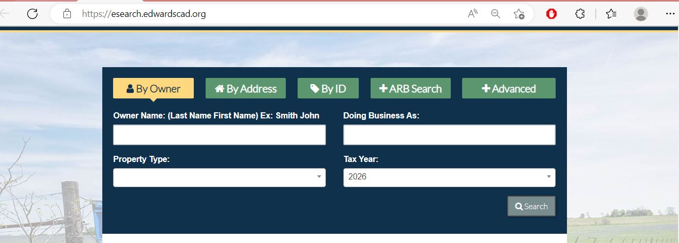
Use the Edwards CAD screenshot to select the right search method

The image already published in the previous article is preserved below and placed inside the practical search workflow. The live portal may change, so use the screenshot as an orientation guide and confirm every field on the official website.

Edwards County Appraisal District property search showing By Owner, By Address, By ID, ARB Search, Advanced, property type and tax year
1. By Owner Enter the owner as LASTNAME FIRSTNAME. Try only one name when a full-name search fails.
2. By Address or By ID Use a simple street name for rural addresses or enter the property ID from a notice or bill.
3. ARB and Advanced Search Use Advanced filters for abstract, subdivision, geographic ID, property type and tax year.
4. Property type and year Confirm both fields before trusting the result or opening a payment route.
A screenshot is not a live appraisal or tax record. Reopen the official account before paying taxes, filing a protest, applying for an exemption or relying on ownership information.
Advanced search guide

Choose Edwards CAD filters that match rural property records

Official search fields and their best use
Search field Use it when Important check
Owner name You know the individual, ranch entity, trust, estate or business. Try the last name alone and reasonable spelling variations.
Doing Business As The account may use a ranch, store, company or trade name. A DBA listing does not prove legal ownership.
Property ID You copied the number from a notice, tax bill or saved record. Confirm property type and tax year after opening it.
Owner ID You need accounts associated with a known owner identifier. One owner can have several unrelated accounts.
Geographic ID You are matching the account with a parcel, map or legal reference. Do not treat it as a professional boundary survey.
Abstract A rural tract is described by survey or abstract rather than address. Match section, survey, tract and acreage.
Subdivision The property is in a named rural subdivision or development. Confirm lot, block, phase and legal description.
Mobile-home park The manufactured home is indexed by a named park. Determine whether the home and land are separate accounts.
Property type You need to separate real, personal, mineral or mobile-home records. Search all types relevant to the owner or location.
Neighborhood You are researching equal appraisal or comparable account groups. A CAD neighborhood is not automatically a sales-market area.
ARB Search You need protest status, informal date, hearing date or formal-date information. The written hearing notice controls the appointment.
Property-record decoder

Understand what each Edwards CAD field does and does not establish

Use each account field as a route to the next controlling document
Field What it helps identify What it does not prove Best next action
Property ID The appraisal account in Edwards CAD’s system. That every outside system uses the same identifier. Use it when calling CAD and matching the tax account.
Geographic ID A parcel identifier connected to geographic or legal mapping. Surveyed boundaries or guaranteed acreage. Compare with maps, deeds and survey evidence.
Owner shown The person or entity carried for appraisal administration. Complete title, lien status or deed history. Search County and District Clerk records.
Situs address The physical address shown when one has been assigned. A mailing address or complete legal description. Compare with the 911 address, map and deed.
Abstract or subdivision The survey, abstract or development associated with the account. The complete tract boundaries. Review the recorded legal description and survey.
Acreage The acreage carried for appraisal purposes. Legally guaranteed or professionally surveyed acreage. Verify with deed, plat and survey documents.
Market value CAD’s opinion of market value as of January 1. A guaranteed sale price or final tax bill. Compare ranch access, terrain, water, improvements and sales.
Productivity value The special value assigned to qualifying agricultural or wildlife-management land. That the property will remain qualified after an ownership or use change. Confirm the current application and land-use history.
Taxable value Value remaining after applicable exemptions and reductions. The live payoff, penalties or payment status. Open the tax record and verify the current balance.
Exemptions Homestead, over-65, disability, veteran or other benefits applied. Every taxing unit grants the same exemption amount. Review taxable value for each taxing unit.
Official county map library

Use Edwards CAD maps for parcel orientation and taxing-area research

Edwards CAD publishes downloadable PDF maps rather than one simple city-style parcel viewer. The map library is particularly useful for rural abstracts, subdivisions, road access and school-district boundaries.

Edwards County map

Use the subdivisions, abstracts and roads map when a rural tract is difficult to find by address.

Rocksprings ISD boundaries

Confirm whether the parcel appears within the Rocksprings school-district area.

Rocksprings city map

Review city-limit parcels and roads for property in or near Rocksprings.

Barksdale city map

Use the Barksdale parcel-and-road map when researching property in that area.

Open the official map page Open Edwards CAD County Maps
Download the relevant PDF Choose the county, school-boundary, Rocksprings or Barksdale map.
Compare the account with the map Match the property ID, geographic ID, abstract, subdivision, road and adjoining property context.
Request a different or printed map when needed Edwards CAD directs custom map questions to its mapping vendor and printed-map requests through its open-records process.
Map accuracy is limited by the available appraisal data. Do not use a CAD map by itself to build a fence, divide a ranch, determine legal access, resolve an encroachment or guarantee acreage.
Ranch, agricultural and wildlife property

Protect Edwards County special valuation with complete land-use evidence

Edwards CAD provides separate applications and guidance for 1-d-1 agricultural appraisal, wildlife management plans and annual wildlife-management reporting.
1-d-1 agricultural appraisal

Prepare ownership, acreage, prior land-use history, current agricultural activity and the required number of livestock or other use details.

Wildlife management

Use the current application, five-year wildlife plan and annual report required for the property’s status.

Leased grazing or ranch use

Attach the current lease agreement when agricultural use depends on a tenant, grazing lease or other operating arrangement.

New owner

Do not assume the seller’s agricultural or wildlife valuation automatically continues after the sale.

Change to wildlife management

A property converting to wildlife management may need the application plus the five-year plan and supporting land-use documents.

Change of use

Ask about additional taxes before changing qualified land to residential, commercial or another nonqualifying use.

Ranch-land evidence checklist

Property ID, abstract and legal description
Acreage and tract map
Livestock type and number of head
Grazing, hunting or agricultural lease
Fencing, water and improvement photographs
Receipts for feed, seed, equipment or services
Wildlife-management practices and dates
Five-year plan and annual report
Prior-year qualification records
Submission confirmation or certified-mail receipt
Wildlife upload warning: Edwards CAD asks users not to upload individual wildlife-management photographs one by one. Combine related photographs and documentation into an organised document before submission.
Value explanation

Separate market value, special appraisal and taxable value

STEP 1 Market value

CAD’s opinion of what the property would sell for under normal conditions as of January 1.

STEP 2 Appraised or productivity value

The applicable value after an appraisal limitation or qualifying agricultural or wildlife-management valuation.

STEP 3 Taxable value

The value remaining after exemptions and reductions for each taxing unit.

Ranch value is not determined by acreage alone. Access, terrain, water, fencing, improvements, hunting use, location, easements, land quality and comparable sales can affect market value.
Do not estimate the final bill from market value alone. Taxable values, exemptions, adopted rates, special districts, penalties and prior payments affect the actual amount due.
Appraisal-notice review

Read every part of the Edwards CAD Notice of Appraised Value

Property identity

Confirm the owner, property ID, mailing address, situs, property type and legal description.

Land categories

Separate non-agricultural market land, agricultural market land and qualifying productivity value.

Improvements

Review houses, cabins, barns, sheds, mobile homes and other appraised improvements.

Exemptions

Check homestead, over-65, disability, veteran and other reductions shown on the account.

Taxable value

Review the value after exemptions rather than confusing it with total market value.

Protest deadline

Use the date printed on the individual notice and preserve the mailing envelope when timing is disputed.

An appraisal notice is not a tax bill. Tax-rate and estimated-tax information becomes clearer later through the Truth-in-Taxation process and the final collection record.
Search troubleshooting

Fix common Edwards CAD search failures before calling

Change one search detail or property type at a time
Problem Likely reason Practical fix
Owner search returns nothing The account may use initials, a spouse, trust, estate, ranch entity or different name order. Search the first or last name alone and try the business name.
Full address fails The rural property may use a ranch road, assigned 911 address or no standard situs address. Search only the street name, then use property ID, owner, abstract or legal description.
Too many owner matches The owner has several tracts or the name is common. Add property type, subdivision, abstract, geographic ID or tax year.
Ranch acreage is missing The land may be divided among several accounts or carried under a different owner or entity. Search every related property ID and compare deeds and maps.
Mobile home does not appear with land The manufactured home may have a separate account. Select the mobile-home property type or park filter.
Mineral account is missing Mineral interests may be separate from the surface tract. Search the mineral property type, owner and related legal information.
New owner is not shown The deed may still be processing into the appraisal system. Confirm recording with the Clerk and provide the instrument information to CAD.
Acreage differs from the deed The appraisal record may use an abbreviated or older description. Prepare the deed, plat and survey before requesting a correction.
CAD and tax balance differ The systems serve different purposes or update at different times. Use the tax-payment record for the live balance and receipt.
Prepared call script
I am researching tax year [year] for Edwards CAD property ID [number], geographic ID [number], owner [name] and legal description [description]. The account currently shows [result or error]. I need help confirming the correct [real, mineral, personal or mobile-home] account and the document required for [search, correction, exemption or protest].
Office routing

Send each Edwards County question to the office that controls the record

Appraisal, collection, addressing and legal records follow different routes
Your question Correct starting point What to prepare
What is the appraised value? Edwards Central Appraisal District Property ID, tax year and disputed value field.
Is agricultural or wildlife valuation active? Edwards Central Appraisal District Application, acreage, land-use records, lease and plan.
Why is an exemption missing? Edwards Central Appraisal District Application, ID, utility bill and qualification evidence.
What is the current tax balance? Edwards County Tax Assessor-Collector or official tax record Property account, owner and tax year.
Did my payment post? Edwards County Tax Assessor-Collector Receipt, confirmation, amount, payment date and account.
Who legally owns the property? Edwards County and District Clerk or title professional Grantor, grantee, date range, instrument and legal description.
Where can I obtain a deed, lien or plat? Edwards County and District Clerk Names, document type, date and property description.
How do I obtain a rural 911 address? Edwards CAD 911 Address Request Parcel ID, ownership, contact and GPS entrance coordinates.
Who sets the tax rate? Each local taxing unit The taxing-unit list from the property record.
Account corrections

Correct the Edwards County record that owns the inaccurate field

Incorrect appraisal owner Confirm the recorded deed, probate order, affidavit or other ownership document and ask CAD which proof it requires.
Incorrect mailing address Contact Edwards CAD for the appraisal record and the Tax Office separately if the tax statement also needs updating.
Incorrect physical address Determine whether the problem involves the appraisal account or the assigned rural 911 address.
Incorrect acreage or boundary Prepare the deed, plat and professional survey. CAD maps do not resolve legal boundary disputes.
Incorrect land class or special valuation Prepare land-use history, livestock records, lease documents, wildlife plan and photographs.
Incorrect tax balance or payment Contact the Tax Assessor-Collector with the account, tax year, amount, payment date and receipt.
A correction and a protest are different. A correction updates inaccurate record information. A protest challenges a value, unequal appraisal, exemption decision, special valuation or another appraisal-district action.
Rural 911 address request

Prepare the parcel and entrance information before requesting an address

Edwards CAD provides a dedicated 911 Address Request route for a house, cabin or other addressed location on a rural parcel.

Find the parcel ID first Search the appraisal record and save the PID for the tract where the house or cabin is or will be located.
Prepare the requester’s contact information Use a phone number and email that can receive follow-up questions and the address confirmation.
Prepare parcel ownership information Confirm the owner shown and have the deed or ownership details available if requested.
Identify the entry point from the road Use the form’s map while at the property or obtain GPS coordinates for the driveway or entrance from the named public road.
Submit the official request Open the Edwards County 911 Address Request
Wait for confirmation Edwards CAD states that applicants should allow several days for the confirmation email.
Contact the post office afterward Confirm whether the assigned location receives postal service and which city and ZIP code should be used.
The entrance location matters. The GPS point should identify where the property is entered from a public or named road, not merely the approximate center of a large ranch.
Exemptions and tax relief

Verify each Edwards County exemption on the current property account

Residence homestead

Confirm that the home is the owner’s principal residence and the exemption appears for the current year.

Age 65 or older

Review the additional exemption, school-tax ceiling and possible instalment or deferral options.

Disabled person

Check the additional exemption and supporting eligibility documentation.

Disabled veteran

Use the correct application and provide a current VA disability decision letter.

Heir property

Review the official heir-property guidance when the residence passed through family without a conventional recorded transfer.

Other exemptions

Use the miscellaneous application and attach every document supporting the claimed qualification.

Homestead filing checklist

Property ID and complete address
Owner name matching the appraisal record
Texas driver licence or qualifying identification
Current utility bill for the permanent residence
Occupancy and qualification date
Age or disability evidence when applicable
VA decision letter for veteran claims
Deed, affidavit or heirship documentation
Signed application
Submission confirmation or mailing proof
Applications must be complete, dated and signed. A missing signature, identification document, utility bill, lease or qualification evidence can delay processing.
Appraisal protest

File an Edwards CAD protest that focuses on a specific appraisal issue

2026 filing rule: most protests are due by May 15 or the 30th day after Edwards CAD mails the Notice of Appraised Value, whichever is later. Use the deadline printed on the notice and confirm it with the district when uncertain.
Save the full property account Keep the property ID, owner, property type, legal description, acreage, land classes, improvements, values and exemptions.
Choose the exact protest reason Common issues include market value, unequal appraisal, incorrect acreage, wrong improvement data, exemption denial or special-valuation denial.
File before the notice deadline Use the official Notice of Protest form or the online protest route. Open Edwards CAD Online Protest
Keep proof of filing Save the electronic confirmation, email receipt, fax confirmation, certified-mail receipt or stamped copy.
Request and review CAD evidence Examine the appraisal schedules, comparable properties, property characteristics, land classifications and special-valuation information.
Organise rural-property evidence Use sales, terrain and access evidence, dated photographs, fencing and water information, surveys, repair estimates, leases and land-use records.
Attempt an informal resolution Explain the requested value or correction and connect every document to the specific issue.
Prepare for the formal ARB hearing Put the strongest evidence first and follow the written hearing notice for the date, time, location and participation method.

Evidence packet that is easy to present

Notice of Appraised Value
Saved Edwards CAD property account
One-page requested-value summary
Comparable sales or equal-appraisal table
Ranch access and terrain photographs
Repair or improvement-condition estimates
Deed, plat, survey or acreage evidence
Agricultural or wildlife-use documentation
CAD evidence with disputed items marked
Proof of timely filing
Do not make the hearing only about a high tax bill. Focus on appraisal issues such as value, equal treatment, property characteristics, acreage, exemptions or special valuation. Taxing units—not the ARB—adopt tax rates.
Appraisal Review Board

Use the correct Edwards County ARB form when the normal process changes

Edwards CAD publishes several forms for owners who need a same-day hearing, rescheduling, affidavit presentation, late-protest request or post-hearing remedy.

Hearing and post-hearing forms available from Edwards CAD
Form or request When it may apply Important requirement
Same-Day Hearing Request You are asking to be scheduled at the next available same-day opportunity. Complete, sign and submit the current form.
Waiver of 15-Day Notice You agree to waive advance-hearing notice for an earlier available date. Understand that you are giving up the normal notice period.
Hearing Reschedule You need another hearing date. Submit promptly and explain the scheduling need.
Affidavit of Evidence You want the ARB to consider written evidence without normal in-person presentation. The affidavit must contain a notarised signature.
Request for Late Protest Hearing The normal deadline was missed but the ARB has not yet approved the appraisal records. Good cause for missing the deadline must be shown.
Motion to Correct A qualifying substantial over-appraisal or statutory correction issue exists after normal protest timing. Use the correct homestead or non-homestead threshold form and satisfy payment rules.
Binding Arbitration An eligible owner wants an alternative to district court after receiving the final ARB order. Read eligibility, filing, deposit and deadline instructions carefully.
Edwards County’s ARB typically begins meeting around late May and completes its review season during the summer. The individual hearing notice and current 2026 procedures control the actual date and method.
Tax bills, payments and receipts

Use the Edwards CAD and Tax portal without paying the wrong account

Edwards County uses the official property-search system as the starting point for online tax payment. Collection questions, receipts and account problems should be confirmed with the Tax Assessor-Collector.

Open the official property and tax search Open Edwards CAD and Tax Property Search
Find the exact account Match the property ID, owner, property type, legal description and tax year.
Check every related account Ranch land, minerals, mobile homes and business personal property can have separate tax balances.
Open the property and select Pay Taxes The portal directs users to the green Pay Taxes button after locating the correct property.
Review the amount and fee Confirm the year, balance, penalties, payment method and service fee before authorising the transaction.
Save the receipt and confirmation Record the property ID, tax year, amount, fee, date and confirmation number.
Confirm posting Reopen the account or contact the Tax Assessor-Collector to verify that payment reached the correct property and year.
Typical penalty and interest progression after a normal February 1 delinquency
Month paid Typical combined penalty and interest What to verify
February 7% Request the live payoff before paying.
March 9% Confirm whether additional charges apply.
April 11% Use the current tax record rather than an old bill.
May 13% Ask about instalment or deferral eligibility when applicable.
June 15% Check the date before attorney collection costs may begin.
July 18% An additional collection fee may apply to qualifying delinquent accounts.
The table is a general delinquency guide, not a payoff quote. A late-issued bill, payment agreement, quarter-payment election, deferral, lawsuit or collection referral can change the amount and due date.
Deeds, liens and legal ownership

Use the Edwards County and District Clerk when title matters

The appraisal owner field is maintained for taxation. Recorded deeds and other instruments maintained by the Clerk are the correct starting point for legal ownership research.
Contact the County and District Clerk Open the Edwards County Clerk page
Prepare all relevant names Search or request records under current and prior owners, spouses, trusts, estates, ranch companies and mineral-interest owners.
Narrow the date range and document type Identify whether you need a deed, deed of trust, release, lien, plat, affidavit, probate record or another instrument.
Compare the legal description Match the survey, abstract, section, tract, subdivision, lot, block and acreage with the CAD account.
Request the correct copy Ask whether a plain or certified copy is required for the transaction or government filing.
Use a professional for title conclusions A public records search does not replace a title examination, legal opinion or boundary survey.
Recently purchased ranch still shows the seller? Confirm the deed was recorded, save the instrument reference and contact Edwards CAD with the ownership documentation it requests.
Buyer, new owner and heir checklist

Complete these checks before relying on an Edwards County ranch record

Confirm every parcel

Match property IDs, geographic IDs, abstracts, legal descriptions, acreage and maps.

Search separate accounts

Check real property, minerals, mobile homes and business personal property.

Verify the tax balance

Review current and delinquent years for every related account.

Check recorded ownership

Review deeds, liens, probate records and releases through the Clerk.

Reapply for exemptions

Do not assume the seller’s homestead exemption or appraisal limitation transfers.

Confirm ag or wildlife status

Ask whether a new application, lease, plan or land-use evidence is required.

Check change-of-use exposure

Understand possible additional taxes before changing agricultural or wildlife land use.

Verify access and boundaries

Review easements, deeded access, road conditions, plats and professional surveys.

Request a 911 address

Use the parcel ID and GPS entrance point when a house or cabin needs an address.

The seller’s current tax bill may understate the buyer’s future taxes. Ownership changes can affect exemptions, appraisal limitations, agricultural or wildlife qualification and taxable value.
Taxing units and tax-rate transparency

Identify every taxing unit attached to the Edwards County parcel

Edwards County

County services and applicable lateral-road taxation.

Rocksprings ISD

Applies to qualifying property within the school-district boundary.

Nueces Canyon CISD

Some Edwards County property may fall within this school district.

City of Rocksprings

Applies to property inside the city’s taxing boundary.

Real-Edwards C&RD

A conservation and reclamation district serving applicable property.

Property-specific list

The complete appraisal account and tax record control which units apply to one parcel.

Open the Truth-in-Taxation portal Open Edwards County Tax-Rate Portal
Search the specific property Use the owner, account or property information accepted by the portal.
Select View for the property Review the taxing units, proposed rates and property-specific estimates.
Subscribe to notifications Use the Subscribe to Notifications option when available to follow local rate activity.
Rates are updated during August and September. Do not treat a proposed rate or prior-year rate as the final amount adopted for the current tax year.
Appraisal data and public reports

Use Edwards CAD reports for deeper value and land research

Certified totals

Review certified appraisal totals and partial-exemption information by year.

Annual reports

Understand district operations, property categories and annual appraisal activity.

Reappraisal plans

See how property categories and geographic areas are scheduled for reappraisal.

Mass-appraisal reports

Review the methods and valuation processes used for property categories.

Appraisal manuals

Study real-property and business-personal-property appraisal practices.

Agricultural land values

Compare published ag-value information with the property’s current productivity record.

Countywide reports do not replace the individual property account. Use reports for context, then verify the live property record and tax year before filing or calculating.
Electronic communications and form uploads

Complete the confirmation step after requesting electronic delivery

Download Form 50-843 Find the Request for Electronic Delivery of Communications with a Tax Official through the CAD website.
Complete the owner and property information Use the exact owner, property ID and email address.
Submit through the official upload page or email Edwards CAD accepts the request through Submit Form or at ecad@swtexas.net. Open form submission
Wait for written confirmation The electronic-delivery election does not become active merely because the form was sent.
Monitor the selected email Check spam folders and update the district if the email address changes.
The election remains active until it is rescinded in writing. Keep the original request and enrollment confirmation with the property records.
2026 property-tax calendar

Important Edwards County appraisal and tax dates

Valuation, ownership and property-use date Most value, ownership, situs and agricultural-use questions begin with the property’s status on January 1.
Business personal-property rendition Most renditions are due April 15. A timely written extension request generally moves the deadline to May 15.
Many exemption, ag and wildlife applications Agricultural, wildlife-management, homestead and other applications commonly use an April 30 deadline, subject to specific late-filing rules.
Normal protest deadline Most protests are due May 15 or the 30th day after Edwards CAD mails the notice, whichever is later.
ARB hearings typically begin Edwards CAD states that the local ARB typically begins meeting around May 30.
Typical appraisal-review completion The local ARB generally works toward completion of the appraisal records during July.
Proposed and adopted tax rates Truth-in-Taxation information is updated as local entities propose and adopt rates.
Tax statements generally begin Tax bills are mailed on or as soon as practicable after October 1.
Normal 2026 tax-year delinquency timing Because January 31, 2027 is a Sunday, the normal next-business-day rule generally allows timely payment on Monday, February 1, 2027. Verify the individual bill.
The date on the individual notice, application, hearing order or bill controls. General dates do not replace a later mailing date, extension, late-filing remedy or postponed delinquency date.
Verified local contacts

Edwards County appraisal, tax and recorded-property offices

Edwards Central Appraisal District
Temporary location:
A.A.G.B.A. Building, left-hand door
205 W. Austin Street
Rocksprings, Texas 78880

Mailing: P.O. Box 858
Rocksprings, Texas 78880

Phone: (830) 683-4189
Fax: (830) 683-4193
Email: ecad@swtexas.net

Chief Appraiser: Renn Rudasill Riley

Monday-Wednesday: 8:00 AM-12:00 PM and 1:00 PM-5:00 PM.

Thursday: 8:00 AM-12:30 PM and 1:00 PM-5:00 PM.

Friday: 8:00 AM-12:30 PM and 1:00 PM-4:00 PM.

Edwards County Tax Assessor-Collector
101 E. Main Street
Rocksprings, Texas 78880
Mailing: P.O. Box 378
Rocksprings, Texas 78880

Phone: (830) 683-2337
Fax: (830) 683-4195
Email: misteed.splawn@co.edwards.tx.us

Tax Assessor-Collector: Mistee Splawn

Monday-Thursday: 8:00 AM-4:30 PM.

Friday: 8:00 AM-4:00 PM.

Lunch closure: 12:00 PM-1:00 PM.

Edwards County and District Clerk
101 E. Main Street
Rocksprings, Texas 78880
Mailing: P.O. Box 184
Rocksprings, Texas 78880

Phone: (830) 683-2235
Fax: (830) 683-5376
Email: clerk@swtexas.net

County and District Clerk: Olga Lydia Reyes

Use for deeds, liens, plats, probate filings and official public records.

Before making a rural trip

Call the office and confirm the current location, holiday closure, lunch period, required documents and accepted payment method.

USPS does not deliver mail to the temporary CAD physical address. Use P.O. Box 858 for regular mailed submissions.

Official action links

Official Edwards County property resources

Edwards CAD homepage

Use for office notices, forms, maps, reports, protests and taxpayer resources.

Open Edwards CAD
Property and tax search

Search appraisal accounts, ARB information and online tax-payment access.

Open property search
Official maps

Download county, abstract, subdivision, road, school and city maps.

Open Edwards CAD maps
Forms and applications

Find homestead, ag, wildlife, protest, rendition and administrative forms.

Open forms
Form submission

Upload signed forms and supporting documents through the official page.

Submit forms
Appraisal notices

Understand notice fields, taxable value, exemptions and protest timing.

Read notice guidance
Protest information

Review ARB procedures, hearing forms and case-preparation guidance.

Open protest information
Online protest

File or manage an eligible protest through the district’s electronic system.

Open online protest
Truth in Taxation

Review taxing units, proposed rates and property-specific tax information.

Open tax-rate portal
Reports and appraisal data

Review certified totals, reappraisal plans, annual reports and ag values.

Open reports
Tax Assessor-Collector

Use for tax balances, receipts, payment questions and collection issues.

Open the Tax Office
County and District Clerk

Use for deeds, liens, plats, probate records and legal ownership documents.

Open the Clerk’s office
Editorial accountability

How this Edwards County guide was improved and reviewed

Mahesh Kumar, editor of AppraisalDistrict.org

Independent review of appraisal, ranch, tax and recorded-property systems

This version preserves the property-search and editor images used in the existing article while replacing the earlier brief guidance with complete rural search steps, screenshot instructions, map use, agricultural and wildlife valuation, 911 addressing, exemptions, protest preparation, tax-payment verification and deed research.

Official resources reviewed include Edwards Central Appraisal District, the Edwards CAD and Tax Property Search, Edwards County Tax Assessor-Collector, Edwards County and District Clerk and Texas Comptroller property-tax guidance.

AppraisalDistrict.org is an independent informational website and is not operated by Edwards Central Appraisal District or Edwards County.

Edwards County answers

10 common Edwards CAD property-search questions

1. What is the official Edwards County Appraisal District website?

The official website is edwardscad.org. Use it for property search, maps, forms, appraisal notices, protests, reports and contact information.

2. How do I search Edwards County property records?

Open the official Edwards CAD and Tax Property Search. Choose By Owner, By Address, By ID or Advanced and confirm the property ID, tax year, property type and legal description.

3. Why does an Edwards CAD address search return no result?

Rural ranches and tracts may not use a normal street-address format. Search only the street name, then try owner, property ID, geographic ID, abstract, subdivision or legal description.

4. Can Edwards CAD maps or acreage be used as a legal survey?

No. Edwards CAD states that legal descriptions and acreage should be verified before legal use. Obtain the recorded deed, plat, title evidence and a professional survey when boundaries matter.

5. How do I apply for agricultural or wildlife-management valuation?

Use the official forms page. Prepare the property and land-use information, required livestock details, current lease when applicable, wildlife-management plan and supporting documentation.

6. What is the Edwards County property-tax protest deadline for 2026?

Most protests are due by May 15 or by the 30th day after Edwards CAD mails the Notice of Appraised Value, whichever is later. The individual notice controls.

7. Can I submit Edwards CAD forms online?

Yes. Download, complete and sign the form, combine the supporting documents and upload them through the official Submit Form page.

8. How do I pay Edwards County property taxes online?

Search the correct property in the official CAD and Tax portal, open the account and select the green Pay Taxes button. Verify the account, property type, year, balance and payment fee before submitting.

9. Where can I search Edwards County deeds and ownership records?

Contact the Edwards County and District Clerk. The Clerk maintains deeds, liens, plats, probate records and other official documents.

10. Where is Edwards Central Appraisal District located?

Edwards CAD currently lists a temporary office at the A.A.G.B.A. Building, left-hand door, 205 West Austin Street, Rocksprings. The mailing address remains P.O. Box 858, Rocksprings, Texas 78880, and the phone number is (830) 683-4189.

Leave a Comment