Jack County, Texas · Ranch land, mineral interests, homes, business property, taxes and protests
Match the Jack CAD Account Before You Trust the Acreage, Mineral Record or Tax Bill
Jack County property searches can involve a Jacksboro residence, Bryson lot, Perrin ranch, agricultural tract, oil or gas interest, mobile home, business equipment or utility account. Those records do not all respond to the same owner or address search.
This guide explains how to search the official Jack CAD database, use the existing search-screen image, decode rural and mineral fields, apply for exemptions, prepare evidence, file a protest, pay through the Tax Office and verify deeds through the County Clerk.
Property IDGeo IDOwner nameLegal descriptionAbstract or subdivisionLease name or number
RANCH + MINERAL SIGNAL STATIONACCOUNT MATCHING
JACK CAD PROPERTY SEARCH2026
REAL ESTATEMINERALPERSONAL PROP
ACCOUNT FOUND
ID + TYPE + LAND MATCHED
SEARCH → VERIFY TYPE → SAVE → ACT
Do not use one search method for every Jack County account.
Real estate, mineral and personal-property records are separate property types. A mineral lease or rural tract may not appear under the surface-property address.
Start with the search and screenshot sections. Continue for ranches, minerals, values, forms, protests, payments, deeds and current local contacts.
Official property search
Search Jack CAD using the most precise available detail
Reliable search order:
property ID or Geo ID → owner name → address → legal description or abstract → subdivision → lease name or lease number → interactive map.
Open the official Jack CAD property search
The search is built into the official CAD website.
Open Jack CAD Property Search
Choose the correct search tab
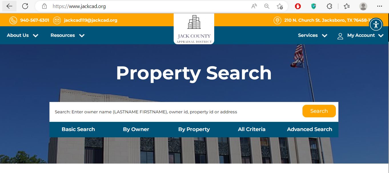
Use Basic Search for a quick lookup, By Owner for name and mailing fields, By Property for property and address details, All Criteria for combined filters or Advanced Search for specialised research.
Select the correct tax year
Use 2026 for the current appraisal account or select an earlier year when comparing ownership, value or exemption history.
Select Real Estate, Mineral or Personal Prop
The wrong property type can produce no result or display a different asset belonging to the same owner.
Use property ID or Geo ID first
These identifiers are normally more reliable than a name or address and help connect the CAD, map and tax records.
Search owner names in portal format
Jack CAD identifies the owner-name format as LASTNAME FIRSTNAME. Start with the last name only when the complete name fails.
Keep address searches short
Begin with the street number and street name. Remove punctuation, highway formatting, city, state and ZIP code if no account appears.
Use legal and lease fields for specialised accounts
Search the legal description, abstract, subdivision, lease name or lease number when the normal address is not useful.
Open every plausible result
Compare the property ID, Geo ID, owner, property type, legal description, acreage, category code and map location.
Save the record before leaving
Print the account or save a PDF or screenshot showing the tax year, identifiers, values, exemptions and date viewed.
Use the tax-due filter carefully.
“Show only Properties with Tax Due” can hide a valid account that has no current balance. Leave it unchecked for a normal owner, appraisal or exemption search.
Existing screenshot retained
Use the Jack CAD search-screen image to choose the correct tab
The current article contains a relevant screenshot of the official Jack CAD search screen. It is retained here because it helps readers recognise the search tabs before opening the live portal.
Existing Jack CAD property-search screenshot retained from the original article. The live interface may change, so verify the current fields on jackcad.org.
1
Basic Search
Enter an owner name, owner ID, property ID or address for a fast first search.
2
By Owner
Use owner ID, owner name, care-of information, street name, city, state or ZIP code.
3
By Property
Use property ID, Geo ID, street components, legal description, abstract, subdivision or lease details.
4
All Criteria
Combine owner and property filters when a common name or broad road search returns too many accounts.
5
Advanced Search
Use category code, acreage, market value, tax value, current or previous owner and recorded-document fields.
Mobile search tip:
enter one strong field at a time. Adding an owner, address, abstract, property type and value range together can make the search too narrow.
10 essential account attributes
Check these 10 Jack CAD fields before relying on the record
1. Property ID
The appraisal account identifier. Save it for forms, calls, protests and tax research.
2. Geo ID
A geographic identifier that helps match the appraisal account to map and land-location information.
3. Owner and Owner ID
The owner entry used for appraisal administration. It is not a complete title history.
4. Property type
Confirm Real Estate, Mineral or Personal Prop before comparing value, owner or tax status.
5. Legal description
Review the abstract, survey, tract, subdivision, lot, block or lease information.
6. Category code
The code helps identify a residence, mobile home, ranch land, farm, mineral interest, commercial property or business asset.
7. Land acres
Compare the acreage with the deed, survey, map and agricultural application.
8. Market value
The district’s value opinion for the appraisal date before exemptions and special treatment.
9. Tax value and exemptions
Tax value can reflect exemptions, appraisal limitations or agricultural-use treatment.
10. Protest and tax-due status
Use the status as a starting point, then verify active protests with CAD and live balances with the Tax Office.
Property category decoder
Use the category code to distinguish ranch, mineral and personal property
Single-family residence
A conventional residential real-property account.
Mobile home
Manufactured housing, including certain permanent double-wide classifications.
Ranch acreage
Ranch land, with a separate code when improvements are present.
Farm land
Farm acreage, with a separate code when improvements are present.
Farm or ranch improvements
Residential or other improvements associated with farm and ranch property.
Oil, gas and mineral
Mineral-right or production-related appraisal accounts.
Commercial personal property
Tangible assets used by a commercial business.
Utility property
Utility, pipeline, telephone, electric, gas or similar specialised property.
Category codes help narrow a search but do not replace the full account. Open the record and confirm the owner, legal description, acreage, improvement details and property type.
Rural parcel verification
Use the interactive map for ranches and parcels without a clear address
Search with a known identifier
Use the property ID, Geo ID, owner, legal description or supported location field.
Compare roads and neighbouring tracts
Check county roads, parcel shape, adjoining owners, abstract position and surrounding land use.
Match the parcel to the appraisal record
Confirm the property ID, Geo ID, legal description and acreage before relying on the map result.
Save the map with supporting documents
Keep the map view with the deed, survey, appraisal notice and evidence packet.
A CAD map is not a legal survey, fence-line determination or mineral-title opinion.
Use a recorded deed, title examination and licensed surveyor for legal ownership or boundary decisions.
Search troubleshooting
Fix a Jack CAD search that returns no account
Change one search detail at a time
Problem
Likely reason
Best next search
Owner name shows nothing
The record may use a spouse, estate, trust, business or different name order.
Use the last name only, owner ID, property ID or previous-owner field.
Ranch address does not work
The tract may be indexed by abstract, survey, legal description or county road formatting.
Use property ID, Geo ID, abstract, legal description or map.
Mineral interest is missing
The search remains set to Real Estate or the account uses lease information.
Select Mineral and try owner, lease name, lease number or property ID.
Business account is missing
The search uses the land owner instead of the business or Personal Prop type.
Select Personal Prop and try the business, owner ID or situs.
Too many accounts appear
The owner has real, mineral and personal-property accounts or the keyword is broad.
Add property type, tax year, category, abstract or property ID.
Valid property disappears
The “tax due” filter may be selected.
Clear the tax-due filter and search the full appraisal roll.
New owner is not displayed
The recorded deed may still be processing or the wrong tax year is selected.
Confirm County Clerk recording and contact CAD with the instrument details.
Acreage looks incorrect
A parcel split, combination, survey change or abbreviated legal description may be involved.
Compare the parent account, deed, survey, plat map and interactive map.
Tax portal and CAD differ
The appraisal and collection systems serve different purposes and may update separately.
Match the property ID, Geo ID, owner, legal description and tax year.
Call script for a missing or incorrect account
I am researching tax year [year] for property ID [number] or Geo ID [number]. The property type should be [Real Estate, Mineral or Personal Property]. I searched by [method], but the portal shows [exact issue]. The legal description, abstract or lease is [details]. Which identifier or document should I use?
Ranch and agricultural land
Review acreage, land use and improvements separately
A Jack County ranch can include multiple tracts, separate homesite acreage, agricultural-use value, barns, fences, tanks, residences and mineral interests. One total value rarely explains the entire account.
Open every related Real Estate account
An owner may have separate tracts, improvement-only accounts or neighbouring property IDs.
Compare property ID, Geo ID and legal description
Make sure each account matches the intended abstract, survey, tract or subdivision.
Review land categories separately
Distinguish ranch acreage, farm land, non-agricultural land, undeveloped land and homesite acreage.
Compare market value with agricultural-use value
Agricultural appraisal does not remove market value. It changes the value used for qualifying acreage.
Review improvements
Check homes, barns, sheds, equipment structures and other improvements associated with the ranch.
Open the 2026 agricultural packet
Use the current official packet and application instead of an older saved form.
Open Jack CAD Agricultural Forms
Preserve evidence of qualifying use
Keep leases, livestock or crop records, photographs, maps, receipts, acreage details and production information.
Agricultural appraisal does not automatically continue unchanged after a sale or change of use.
Ask Jack CAD about continued qualification, new-owner filing and possible additional tax consequences before changing the land’s use.
Mineral and lease records
Search mineral interests independently from the surface property
Jack CAD publishes separate certified mineral appraisal-roll files and provides Mineral as a property type in the public search. This confirms that mineral accounts must be researched independently from ordinary real estate.
Select Mineral before searching
Do not leave the property type set to Real Estate.
Search the mineral owner
Try individual, trust, estate, company and prior-owner variations.
Search the lease
Use lease name or lease number when the owner search is broad or incomplete.
Save the mineral property ID and Geo ID
Do not rely only on the surface-property account or street address.
Confirm the appraisal year
Mineral ownership and valuation information can change between tax years.
Compare with recorded ownership documents
Use deeds, mineral deeds, probate records, assignments and title research when legal ownership matters.
The surface owner and mineral owner can be different.
A CAD mineral account is not a complete mineral-title examination. Obtain professional title assistance for ownership, royalty or lease disputes.
Value interpretation
Read market, appraised and tax value in the correct order
STEP 1Market value
The appraisal district’s opinion of market value for the appraisal date.
STEP 2Appraised or special-use value
The value after an applicable limitation or agricultural-use treatment.
STEP 3Tax value
The value used after applicable exemptions and property-tax treatment.
Different account types require different value checks
Account
Review
Useful evidence
Residence
Land, square footage, age, construction class, condition, additions and exemptions.
Measurements, photographs, repair estimates and comparable sales.
Ranch or farm
Acreage, land class, homesite, agricultural use, improvements and market value.
Survey, map, leases, use history, production records and comparable land sales.
Mineral
Owner, lease, property ID, Geo ID, interest and appraisal year.
Mineral deed, lease documents, ownership records and specialised valuation data.
Business personal property
Assets, acquisition dates, original cost, condition, inventory and depreciation.
Asset list, invoices, disposal records, photographs and depreciation schedules.
Do not use the county page’s old rate examples as a 2026 estimate.
Jack County’s Tax Assessor page contains historical rates and older jurisdiction details. Use the current statement, current tax portal and current rate-adoption information for a live calculation.
Correct office first
Route appraisal, payment and deed questions correctly
Which Jack County office controls the answer?
Your question
Correct office
Prepare
What is the property’s appraised value?
Jack County Appraisal District
Property ID, Geo ID, property type, year and disputed field.
Why is an exemption or agricultural appraisal missing?
Jack County Appraisal District
Application, qualification date, supporting documents and submission proof.
How much property tax is due?
Jack County Tax Assessor-Collector
Tax account, property ID, owner, year and statement.
Did my payment post?
Jack County Tax Assessor-Collector
Payment confirmation, amount, date and tax year.
Who owns the land or mineral interest?
Jack County Clerk or title professional
Grantor, grantee, legal description, lease and date range.
Where can I obtain a deed or lien?
Jack County Clerk
Names, instrument type, recording period and legal description.
Is the acreage or boundary legally correct?
Licensed surveyor and title professional
Recorded deed, plat, prior survey and CAD map.
Property-record corrections
Correct the database that controls the inaccurate field
Incorrect owner name
Confirm the deed or probate document was recorded and provide the instrument details to Jack CAD.
Incorrect mailing address
Use the official Change of Address form and keep a copy of the submitted request.
Incorrect acreage or legal description
Compare the deed, survey, abstract, plat map and CAD map before requesting a correction.
Wrong property type or category
Save the account and explain whether it should be real estate, mineral or personal property.
Improvement-only account should be dissolved
Jack CAD publishes a Request to Dissolve Improvement Only Account form.
Multiple properties should be combined
Review the Request to Combine Properties form and confirm eligibility with CAD.
A correction request does not automatically protect a protest deadline.
File a timely protest when the issue is a protestable appraisal-district action and it remains unresolved.
Exemptions and applications
Use the current Jack CAD form and attach the required proof
Residence homestead
Confirm ownership, principal-residence use, property ID, address and identification requirements.
Age 65 or older
Review additional exemption, school-tax ceiling, deferral and instalment-payment rules.
Disabled person
Prepare the required eligibility documentation and review available homestead benefits.
Disabled veteran
Use the official veteran form and attach the required VA rating or survivor documentation.
Agricultural appraisal
Use the 2026 information packet and application with land-use and acreage evidence.
Deferral
Jack CAD publishes a Tax Deferral Affidavit for qualifying over-65 or disabled homeowners.
Property ID and Geo ID
Owner name and property address
Correct tax year
Driver licence or required identification
Qualification date
Age, disability or VA evidence
Agricultural or wildlife records
Copy and delivery confirmation
Jack CAD’s forms page states that all homestead applications must include a copy of the applicant’s driver licence or other information required by the Texas Property Tax Code. An affidavit can also be required in certain situations.
Connect the wildlife plan to qualifying agricultural land
Wildlife management is not a stand-alone exemption for any rural tract. The land must meet the applicable open-space requirements and the owner must document qualifying wildlife-management practices.
Confirm the land currently qualifies
Open the property account and verify the acreage and agricultural treatment.
Download the official wildlife guidelines
Jack CAD provides Wildlife Management Plan Guidelines and the relevant agricultural forms.
Open Wildlife Management Forms
Map the qualifying acreage
Separate the residence, homesite and non-qualifying acreage from the wildlife-management area.
Document active practices
Keep dated photographs, receipts, maps and records of habitat control, erosion control, predator management, supplemental water, food or shelter.
Maintain annual records
Do not rely on the initial plan alone. Preserve evidence that the plan was implemented.
Business personal property
Use the 2026 depreciation schedule when reviewing a rendition
Jack CAD’s Data and Records page publishes a 2026 depreciation schedule, and its Forms page provides the Personal Property Rendition Form and instruction guide.
Business legal name and DBA
Owner ID and property ID
Physical business location
Assets owned or managed on January 1
Furniture, fixtures and equipment
Inventory and supplies
Leased or consigned assets
Acquisition dates and original costs
General filing rule:
most 2026 business-personal-property renditions were due April 15. A timely written extension request generally moved the deadline to May 15.
A required rendition filed late can result in a statutory penalty. Preserve the submitted form, extension request and delivery confirmation.
Build a Jack CAD protest around the specific account error
Usual protest rule:
most protests are due by May 15 or 30 days after the appraisal district mails the Notice of Appraised Value, whichever is later. The date printed on the notice controls.
Save the property record and notice
Keep the property ID, Geo ID, property type, legal description, values, exemptions and protest deadline.
Select the exact protest reason
Examples include market value, unequal appraisal, wrong acreage, incorrect improvement details, denied exemption, denied agricultural appraisal, mineral-account error or business-property error.
Open the official online protest service
Jack CAD redirects online protest users to account sign-in.
Open Jack CAD Online Protest
Register or recover access early
Do not wait until the filing deadline to create an account, reset a password or request a PIN.
Use the Notice of Protest form when needed
Download the official form from the Jack CAD Forms page and keep proof of filing.
Build evidence for the property type
A residence, ranch, mineral lease and business asset account require different proof.
Review the district’s evidence
Compare the property characteristics, sales, schedules or specialised valuation information with your evidence.
Try to resolve clear factual errors
Explain the exact requested correction and review any proposed agreement before accepting it.
Prepare for the formal ARB hearing
Lead with the property ID, disputed action, requested result and strongest evidence.
Read the written order and appeal information
Preserve the order and promptly review any arbitration or court deadline that applies.
Evidence matched to common Jack County protests
Account
Useful evidence
Common mistake
Residence
Comparable sales, condition photographs, repair estimates, measurements and property-detail corrections.
Comparing only sale prices without adjusting for size, condition or location.
Ranch or farm
Survey, acreage, land class, use records, maps, leases and comparable land sales.
Arguing only that the tax bill is high.
Mineral
Lease, ownership interest, production information, operator data and mineral deed records.
Using the surface owner or address as the only identifier.
Business personal property
Asset list, costs, disposal records, obsolescence, condition and depreciation schedule.
Submitting only a total requested value without identifying disputed assets.
Request the Jack CAD property PIN before a deadline
Jack CAD assigns a unique Online Account PIN to a property. The PIN is different from the property ID and should be treated as private account-access information.
Create an account if necessary
Register using an email address that you monitor.
Sign in and complete the request
Provide the property and identity information requested by the portal.
Match the property before using the PIN
Confirm the property ID, owner and tax year.
Store the PIN securely
Do not publish an appraisal notice or letter containing the PIN.
Request access early.
Account registration, verification, email delivery or password recovery can take time. A portal problem does not automatically extend a statutory protest deadline.
ARB hearing preparation
Use the current Jack County hearing procedures and schedule
Jack CAD’s Data and Records page publishes 2026 Appraisal Review Board hearing procedures, and the website provides a Protest Hearing Search for past, open and scheduled matters.
Use the Jack County Tax Office for the live collection account
The Jack County Tax Assessor-Collector states that, since August 1, 2021, all property taxes for parcels located in Jack County are collected by the Tax Office. Overlapping school parcels are collected by the county where the property is located.
Search the tax account
Use the owner, property ID, address or available search fields and match the result with the CAD account.
Check the correct tax year
Review current, prior-year, partial and delinquent balances.
Select the official Pay Taxes option
The county tax website links to its payment provider. Begin from the county site rather than an advertisement or emailed payment link.
Review the fee before authorising payment
At the July 2026 review, the Tax Office website published an additional 2.25% fee for debit and credit card property-tax transactions. The live checkout total controls.
Save the payment confirmation
Keep the property account, tax year, amount, fee, date, payment method and confirmation number.
Verify posting
Reopen the tax account after processing and make sure the payment was credited to the correct property and year.
Tax certificate
The Jack County Tax Office issues tax certificates for property located in the county.
One green statement
The county states that owners receive one green statement containing the taxing entities collected by the Tax Office.
Call before visiting
The tax website advises calling because occasional unexpected closures can occur.
Do not ask Jack CAD to correct a payment or issue a tax receipt.
Jack CAD supplies appraisal information. The Tax Office controls the bill, balance, payment, tax certificate and receipt.
Recorded property documents
Use the Jack County Clerk for deeds, liens and Official Public Records
Online record coverage:
the County Clerk page links an official online deed and Official Public Records search covering records from 1989 to the present.
Select the online deed-record link
Use the link published under “Search Online Deed Records and OPR from 1989 to present.”
Search name variations
Try the grantor, grantee, spouse, trust, estate, business and prior owner.
Compare the legal description
Match the abstract, survey, tract, lot, block or other recorded description with the CAD account.
Review related instruments
Look for deeds, mineral deeds, deeds of trust, liens, releases, assignments, affidavits and probate-related documents.
Ask for the correct copy type
Confirm whether the intended use requires a plain or certified copy and verify the current Clerk fee.
Bring valid identification for an in-person property-record filing.
The Jack County Clerk states that valid ID is required when presenting in-person documents for filing in Property Records.
The CAD owner field is not a title report. Obtain a title examination or legal advice when ownership, mineral rights, liens, easements or releases affect a transaction.
Buyer and heir checklist
Complete these checks before relying on a Jack County account
Confirm the deed or probate instrument was recorded
Save the County Clerk instrument details
Match property ID and Geo ID
Compare abstract, survey, tract and acreage
Search Real Estate and Mineral separately
Review every related property account
Check exemptions under the new owner
Verify agricultural or wildlife qualification
Search current and delinquent taxes
Review lease and mineral-title information
Compare the CAD map with a professional survey
Save closing, title, survey and tax documents
The seller’s current tax amount may not predict the buyer’s future bill.
Homestead caps, exemptions, agricultural treatment, wildlife qualification and owner-specific benefits can change after a sale or change of use.
Data and transparency
Use Jack CAD reports, certified rolls and depreciation data
2026 depreciation schedule
Useful for reviewing business-personal-property asset valuation.
2025 annual report
Provides information about the appraisal district and countywide appraisal base.
2025-2026 reappraisal plan
Explains the district’s planned appraisal and property-review work.
Mass appraisal reports
Describe valuation methods, property categories and appraisal procedures.
Certified real and personal rolls
Available in PDF and spreadsheet formats for completed appraisal years.
Certified mineral rolls
Separate downloadable files support mineral-account and countywide research.
Plat map
Jack CAD publishes a 2019 county plat-map PDF for general parcel context.
Five-year tax history
Useful for historical comparison, not as a substitute for a current 2026 rate.
2026 ARB procedures
Use the current hearing-procedure document when preparing for an appraisal hearing.
Appraisal and property-status date
Ownership, use, condition, mineral interests, business assets and many exemption qualifications are generally evaluated as of January 1.
Most business renditions
Most 2026 business-personal-property renditions were due, subject to a timely written extension request.
Many exemption and special-appraisal applications
The normal date applied to many homestead, agricultural and wildlife filings, subject to statutory late-filing provisions.
Most appraisal protests
Most 2026 protests were due by May 15 or 30 days after the appraisal notice was mailed, whichever was later.
ARB completion and certification period
Appraisal-review work and roll certification normally occur during the summer. Confirm the live account status before relying on a value.
Tax-rate proposal and adoption
Local taxing units calculate, publish and adopt current-year rates.
Property-tax statements generally begin
Jack County states that owners receive one green statement for the entities collected by the Tax Office.
Normal 2026 tax-year payment timing
January 31, 2027 falls on a Sunday. Under the Texas next-business-day rule, a normal payment should generally remain timely on Monday, February 1, 2027. Follow the bill.
The individual notice, bill, supplemental notice or ARB order controls.
Corrected accounts, late notices and special circumstances can have different deadlines.
Verified local contacts
Jack County appraisal, tax and deed offices
Jack County Appraisal District
210 N. Church Street
Jacksboro, Texas 76458
Call before travelling.
Confirm holiday closures, identification requirements, payment methods and whether the issue belongs to Jack CAD, the Tax Office or County Clerk.
Official action links
Official Jack County property resources
Property search
Search real estate, mineral and personal-property accounts.
1. What is the official Jack County Appraisal District website?
The official website is jackcad.org. It provides property search, forms, online protest access, account PIN requests, mapping, reports and contact details.
2. How do I search Jack County property records?
Use Basic Search, By Owner, By Property, All Criteria or Advanced Search. You can search by owner, property ID, Geo ID, address, legal description, abstract, subdivision, lease name or lease number.
3. Why can I not find a Jack County ranch by address?
Rural land may be indexed by property ID, Geo ID, owner, legal description, abstract, survey or tract rather than a normal street address. Use Advanced Search and the interactive map.
4. How do I search Jack County mineral records?
Select Mineral as the property type and search by owner, property ID, Geo ID, lease name or lease number. The mineral owner may differ from the surface owner.
5. Does Jack CAD collect property taxes?
Jack CAD handles appraisal values, exemptions, agricultural treatment and protests. The Jack County Tax Office collects property taxes for parcels located in Jack County.
6. Where can I pay Jack County property taxes online?
Open jackcountytax.org, locate the correct account, select the official Pay Taxes option, review the fee and save the confirmation.
7. What is the Jack CAD protest deadline?
Most protests are due by May 15 or 30 days after the Notice of Appraised Value was mailed, whichever is later. Follow the deadline printed on the individual notice.
8. Where can I request a Jack CAD online account PIN?
Use the official Get Pin page. You may need to create an account or sign in before completing the request.
9. Where can I search Jack County deeds and liens?
Use the Jack County Clerk and select the online deed and Official Public Records search. Online coverage is listed from 1989 to the present.
10. Where is Jack County Appraisal District located?
Jack CAD is at 210 N. Church Street, Jacksboro, Texas 76458. The phone number is (940) 567-6301.