
Sherman CAD Property Search, Pay Taxes, Map and Protest Help
This Sherman County guide helps property owners use the official CAD search, pay-taxes link, interactive map, forms, online protest access, and contact details without confusing appraisal records with county tax-office services.
Sherman County is a Panhandle county where property searches may involve Stratford, Texhoma, rural acreage, farm and ranch property, mineral accounts, school districts, hospital districts, and underground water district taxing units.
Quick Answer for Sherman County Property Owners
Sherman County Appraisal District maintains appraisal records, property search access, exemptions, forms, online protest resources, interactive map access, records, reports, and property tax payment links through the official CAD website.
Use Sherman CAD for value, exemptions, property records, protest, map search, and the CAD-linked payment route. Use the Sherman County Tax Assessor-Collector for county tax office matters, title/registration services, and county-office questions.
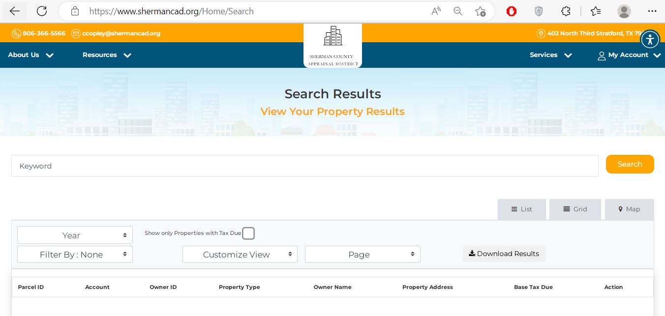
Official Sherman CAD and County Resources
Start with official resources first. This helps avoid outdated forms, old phone numbers, copied property pages, and unsafe payment links.
| Need | Official Resource | Why It Matters |
|---|---|---|
| CAD homepage | Sherman CAD official website | Main source for property search, forms, online protest, map, pay taxes, records, reports, policies, and contact details. |
| Property search | Sherman CAD property search | Search by keyword, owner, property ID, address, legal description, lease number, property type, and tax year. |
| Interactive map | Sherman CAD interactive map | Helpful for rural land, parcels near county roads, farm/ranch tracts, nearby property review, and map-based research. |
| Forms | Sherman CAD forms | Use official forms for exemptions, renditions, protest-related filing, and property-owner requests. |
| Online protest | Sherman CAD online protest | Use official protest access or request-a-PIN resources when your notice allows online filing. |
| Pay taxes | Certified Payments | Sherman CAD links Pay Taxes Online to Certified Payments. Verify the property account and payment details before paying. |
| County tax office | Sherman County official website | Useful for county tax assessor-collector details, title/registration matters, and county office contact information. |
| State verification | Texas Comptroller Sherman directory | Cross-check chief appraiser, CAD address, tax assessor-collector, active taxing units, and contact details. |
How to Search Sherman County Property Records
The official Sherman CAD search supports Basic Search, By Owner, By Property, All Criteria, and Advanced Search. It also lets users select tax year, property type, tax-due-only results, and sort options.
Open the official search page
Go to the official Sherman CAD property search. Use this before paying any third-party property record website.
Start with the cleanest detail
If you have property ID or owner ID, use that first. If not, try owner name, address, legal description, street name, or lease number where available.
Choose the correct property type
Sherman CAD search includes Mineral, Personal Property, and Real Estate filters. If the first search does not work, change the property type and search again.
Check the tax year and tax-due filter
Make sure the correct tax year is selected. Use “show only properties with tax due” only when your goal is payment or balance review.
Save the record before action
Save a screenshot or PDF before filing a form, paying taxes, preparing a protest, or calling the CAD or tax office.
Local search tip: Sherman County records may involve Stratford, Texhoma, rural acreage, farm and ranch property, mineral interests, personal property, school district accounts, hospital district accounts, and water district taxing units. If a normal address search fails, try property ID, owner ID, legal description, lease number, or map search.
Sherman County Property Tax Payment: What to Check First
The Sherman CAD website links to Pay Taxes Online through Certified Payments. Before paying, confirm the owner name, property ID, tax year, tax due amount, property type, and payment confirmation details.
When the Interactive Map Helps
The interactive map is useful when a property is easier to identify by location than by address. This is common with rural land, farm tracts, county-road property, and parcels where mailing address and physical location are not the same.
CAD, Tax Assessor-Collector or County Clerk?
Sherman County property questions can involve different offices. Use the correct office so you do not lose time during appraisal notice, protest, or payment season.
| Your Question | Best Place to Start | Reason |
|---|---|---|
| What is my appraised value? | Sherman CAD | The appraisal district maintains appraisal records and property values. |
| Where do I search owner, address, property ID or lease number? | Sherman CAD property search | The official search is the best source for appraisal record lookup. |
| Where do I file homestead, ag, rendition or protest forms? | Sherman CAD forms | Exemptions, special valuations, renditions, and appraisal protests are appraisal district matters. |
| Where do I ask about county tax office services? | Sherman County Tax Assessor-Collector | The county tax office handles county tax office duties, vehicle/title services, and county-specific tax assessor questions. |
| Where do I get deed or recorded document copies? | County Clerk | Deeds, liens, plats, probate, and recorded legal documents are not the same as CAD appraisal records. |
Exemptions, Renditions, Agricultural Valuation and CAD Forms
Use official Sherman CAD forms when you need an exemption, agricultural or open-space review, business personal property rendition, protest form, or property-owner filing.
| Situation | Likely Starting Point | What to Prepare |
|---|---|---|
| You live in the home as your main residence | Residence homestead exemption | Owner name, property address, property ID, ID/address match, and correct tax year. |
| You are over 65, disabled, a disabled veteran, or surviving spouse | Matching exemption form | Proof documents, required ID, ownership details, and award/rating proof if applicable. |
| You own farm, ranch, agricultural, or open-space land | Special valuation or agricultural form | Land-use history, production records, leases, maps, irrigation details if relevant, and supporting evidence. |
| You own business personal property | Rendition form | Asset list, business location, equipment details, inventory details, and ownership records. |
Practical tip: If you recently bought property in Sherman County, confirm the owner name and mailing address in the CAD record. Old mailing information can cause missed notices, exemption problems, and protest deadline issues.
How to Prepare a Sherman CAD Protest
A useful protest explains the exact issue. Instead of only saying “my tax is too high,” identify whether the problem is market value, unequal appraisal, wrong property details, missing exemption, mineral valuation, agricultural valuation, or business personal property.
Read your notice first
Check account number, appraised value, property type, exemption status, protest deadline, and any online protest instruction shown on the notice.
Compare the CAD record
Review owner name, mailing address, legal description, acreage, improvements, land use, mineral details, business assets, tax year, and prior value.
Collect useful evidence
Evidence may include photos, repair estimates, closing documents, comparable sales, lease records, production records, business asset lists, or proof of incorrect property details.
Use official protest access
Use the official Sherman CAD online protest link or the correct protest form. Keep proof of filing.
Deadline warning: Always follow the date printed on your official notice or confirmed by Sherman CAD. Do not wait until every document is perfect if the filing deadline is close.
Common Sherman CAD Search Problems and Fixes
| Problem | Likely Reason | Try This |
|---|---|---|
| Owner name is not found | The record may use a different name format, trust name, company name, or estate name. | Try last name only, business keyword, owner ID, property ID, or LASTNAME FIRSTNAME. |
| Address search fails | Farm land, county-road property, mineral accounts, or rural tracts may not use a normal postal-style address. | Use property ID, owner name, legal description, lease number, map search, or fewer address words. |
| Tax payment is confusing | The CAD site links to Certified Payments, while county tax office services are separate. | Start from the official Sherman CAD Pay Taxes Online link or call the office before paying. |
| Exemption is missing | The application may be incomplete, not filed, not processed, or not applied to that tax year. | Check official forms, save filing proof, and contact Sherman CAD with property ID and owner details ready. |
| Property type looks wrong | The search separates Mineral, Personal Property, and Real Estate records. | Change the property type filter and search again using owner ID, property ID, or lease number. |
Documents to Keep Ready Before Calling
Having the right details ready helps the CAD staff find your record faster, especially during appraisal notice, protest, and property tax payment periods.
- Owner name shown on the record
- Owner ID, property ID, account number, or legal description
- Property address, lease number, or location description
- Tax year you are asking about
- Notice of Appraised Value or CAD screenshot
- Property ID and owner name
- Tax year and amount due
- Payment confirmation or receipt if already paid
- Tax due screenshot from the CAD record
- Any mailed tax bill or notice received
Sherman CAD Phone Number, Address and Map
Stratford, TX 79084-0239
Mailing: P.O. Box 239, Stratford, TX 79084-0239
Phone: 806-366-5566
Fax: 806-366-2565
Email: ccopley@shermancad.org
Chief Appraiser: Courtney Copley
402 N. 3rd St.
Stratford, TX 79084
Mailing: P.O. Box 1229, Stratford, TX 79084-1229
Phone: 806-366-2150
Fax: 806-366-2854
Email: kalee.flippin@co.sherman.tx.us
Active taxing-unit note: Sherman CAD serves several taxing units, including Sherman County, Stratford ISD, Texhoma ISD, Gruver ISD, Pringle-Morse CISD, City of Stratford, City of Texhoma, hospital districts, and the North Plains Underground Water Conservation District. Always confirm the taxing units shown on your exact property record.
Sherman County Appraisal District FAQs
What is the official Sherman CAD website?
The official website is shermancad.org. Use it for property search, forms, online protest, interactive map, pay taxes online, records, reports, and contact details.
How do I search Sherman County property records?
Use the official Sherman CAD property search and search by owner name, owner ID, property ID, address, legal description, lease number, tax year, or property type.
Can I pay Sherman County property taxes online?
Yes. Sherman CAD links to Pay Taxes Online through Certified Payments. Confirm the account, owner, tax year, amount due, and confirmation number before relying on the payment.
Does Sherman CAD have an interactive map?
Yes. Sherman CAD links to an interactive map for rural land, parcel location, nearby property context, and map-based property research.
Where do I get Sherman CAD forms?
Use the official Sherman CAD forms section for exemption, rendition, protest-related, and property-owner request forms.
Where is Sherman County Appraisal District located?
Sherman County Appraisal District is located at 402 N. 3rd St., Stratford, TX 79084.
What is the Sherman CAD phone number?
The Sherman CAD phone number is 806-366-5566. The fax number is 806-366-2565.
Who is the Sherman CAD chief appraiser?
The Texas Comptroller directory lists Courtney Copley as the Sherman County Appraisal District chief appraiser.
Who is the Sherman County Tax Assessor-Collector?
The Texas Comptroller directory lists Kalee Flippin as the Sherman County Tax Assessor-Collector.
Is AppraisalDistrict.org the official Sherman CAD website?
No. AppraisalDistrict.org is an independent public guide. Always verify property values, tax bills, payments, forms, deadlines, and office instructions with Sherman CAD, Sherman County official resources, or the Texas Comptroller.
Important Note
AppraisalDistrict.org is an independent public guide and is not the official Sherman County Appraisal District website.
Always confirm property values, exemptions, protest deadlines, tax bills, tax rates, payment status, and office procedures with the official appraisal district, county office, or Texas Comptroller resources before taking action.

Founded by Mahesh Kumar, AppraisalDistrict.org is built on the belief that public information should be accessible and accurate. We have replaced AI-generated ‘fluff’ and automated scraping with 100% manual human verification. With over 15 years of experience in real estate and digital journalism, we help you find the right data without the frustration of broken links.
Search Smarter, Estimate Taxes, Check Exemptions and Prepare for a Protest
Use this free tool before you visit a county appraisal district, property search portal, tax office, or exemption page. It helps you understand property value, taxable value, possible savings, protest value, and the next official step.
What do you need help with today?
Choose your main reason for visiting. The tool will show the best next step and quick estimate.
Use this tool to check your appraisal notice, exemption savings, protest value, and official next step.
Use the tax calculator before trusting only the sale price or mortgage estimate.
Property Search Helper
Use this when a county property search portal is confusing. It shows which search method is usually best.
Property Tax Estimate Calculator
Estimate annual property tax using appraised value, assessment ratio, exemptions, and combined tax rate.
Homestead and Exemption Savings
Estimate how much a homestead, senior, disability, veteran, or local exemption may reduce tax.
Appraisal Notice Review
Compare last year value with this year value and see whether the increase deserves closer review.
Property Tax Protest Savings
Estimate possible savings if your appraised value is reduced after protest, correction, evidence review, or appraisal review board hearing.
Property Tax Protest and Exemption Checklist
Use this checklist before you file a protest, apply for exemption, or call the appraisal district.
Before calling, write your property ID, owner name, property address, and question on paper. It saves time.
Do not call the CAD to pay tax bills unless the local article says they collect taxes. In many counties, the tax office collects payment.
Official Resource Finder
Enter county and state to create safe searches for official CAD pages, property search, tax payment, exemptions, maps, forms, and protest help.
CAD vs Tax Office
- Appraisal District: value, exemptions, ownership records, maps, protest.
- Tax Office: tax bill, payment, receipt, delinquent balance, penalty.
Best place to use this
Add this tool after the first major content section or before the FAQ area. It gives visitors a reason to interact before leaving the page.
Important estimate note
This tool gives educational estimates only. Final values, exemptions, tax rates, bills, payments, and deadlines must be confirmed with official county sources.