Sort a Fisher County Property From Search Result to the Correct Tax or Deed Record
Start with Fisher County Appraisal District when you need the parcel ID, property ID, owner, address, legal description, abstract, acreage, market value, exemption status, tax due information, agricultural appraisal or protest details.
Fisher County works differently from many Texas counties: the appraisal district is also the local starting point for house and property-tax payments. The County Tax Assessor-Collector mainly handles vehicle titles, registration and voter registration, while the County Clerk maintains deeds and other recorded land documents.
Use the property ID or geographic ID when one is available.
Pay house and land taxes through Fisher CAD’s official route.
107 E. North First Street, Roby, Texas 79543.
Mineral, utility and industrial accounts are appraised by Pritchard & Abbott.
Local portals and procedures reviewed July 2026.
What do you need from the Fisher County property record?
Use an owner, property ID, address, legal description, abstract or subdivision, then confirm the full account.
Follow the search workflowConfirm the parcel, tax year, amount and payment-provider fee before submitting.
Review the payment stepsReview market value, appraisal limitations, exemptions, property characteristics and tax due fields.
Understand the accountIdentify whether the issue is value, unequal appraisal, acreage, ownership, exemption or property description.
Build a protest fileSearch recorded deeds, liens, releases and land records rather than treating the CAD owner field as legal title proof.
Search official land recordsSurface real estate, minerals, business personal property and special-use land may appear in separate accounts.
Review local scenariosSearch Fisher County property records without selecting the wrong account type
Use the Fisher CAD screenshot to understand the live result screen
The image already published in the existing article is preserved below. It shows the Fisher CAD result page and the controls visitors should use before opening or downloading an account.
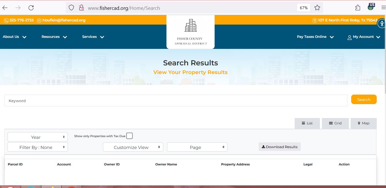
Choose the Fisher CAD search fields that match your property
| Search option | Best use | Practical tip |
|---|---|---|
| Basic Search | Quick owner, owner-ID, property-ID or address lookup. | Start with one distinctive detail and then narrow the result. |
| By Owner | Find accounts associated with a person, estate, trust, company or care-of address. | Enter the name in LASTNAME FIRSTNAME order or use a partial last name. |
| By Property | Search by property ID, geographic ID, street, legal description, abstract or subdivision. | Use this route for rural land without a dependable street address. |
| All Criteria | Combine owner, parcel, legal, lease, property type, agent and protest-status filters. | Add one filter at a time so you know which field excluded a result. |
| Property type | Separate Real Estate, Personal Property and Mineral accounts. | A surface tract and mineral interest may have separate property IDs. |
| Abstract | Find rural acreage using the survey or abstract reference. | Compare the abstract, legal description, acreage and map. |
| Lease number or name | Research oil, gas or other mineral-related accounts. | Search both the lease and owner when one field produces too many results. |
| Tax due | Limit results to accounts showing base tax due. | Open the detail and verify the tax year and complete amount before paying. |
Understand what a Fisher CAD account tells you
| Field | What it helps identify | What it does not prove | Next action |
|---|---|---|---|
| Parcel or property ID | The appraisal account used in Fisher CAD’s system. | That every outside office uses the same identifier. | Save it before calling, paying or protesting. |
| Geographic ID | A parcel identifier associated with the legal or mapping record. | A surveyed boundary or guaranteed acreage. | Compare it with the map, deed, plat and survey. |
| Owner shown | The owner carried for appraisal and collection administration. | Complete legal title or lien status. | Search County Clerk land records when ownership matters. |
| Legal description | The lot, block, tract, abstract, subdivision or other abbreviated legal reference. | That the description is sufficient for a deed or survey. | Open the recorded deed or plat. |
| Total acres | The acreage carried for appraisal purposes. | Legally guaranteed or surveyed acreage. | Verify the deed and professional survey. |
| Category code | How the property is classified for appraisal. | That the current use, condition or classification is correct. | Compare the code with actual use and supporting records. |
| Market value | The appraisal district’s opinion of market value as of January 1. | A sale price or final tax bill. | Review property facts, sales and equal-appraisal evidence. |
| Taxable value | Value after applicable exemptions or appraisal limitations. | The final payoff or whether payment has posted. | Open the tax section or contact Fisher CAD. |
| Base tax due | A tax amount shown for the selected account or year. | The complete current payoff including every penalty, fee or later payment. | Confirm the live amount before paying. |
| Deed history | Recorded-document references carried in the appraisal system. | Complete title or every recorded lien. | Search Fisher County Clerk records. |
Use the Fisher CAD map to confirm location, not legal boundaries
Separate market value, appraised value and the amount of tax due
Fisher CAD’s opinion of what the property would sell for under normal market conditions as of January 1.
The value after an applicable appraisal limitation, special appraisal or exemption.
The amount produced from taxable values, adopted rates, exemptions, ceilings, penalties and payment history.
Fix common Fisher CAD property-search problems
| Problem | Likely reason | Practical fix |
|---|---|---|
| Owner name returns nothing | The portal may use last-name-first-name order, initials, a spouse, estate, trust or business name. | Search the last name only or use the owner ID. |
| Full address fails | The account may omit a suffix, city, direction or rural-route detail. | Use only the street name or switch to property ID or legal description. |
| Rural acreage has no situs address | The parcel may be indexed by abstract, subdivision, legal description or geographic ID. | Use By Property or All Criteria and then check the map. |
| Mineral interest is missing | The search may still be filtered to Real Estate. | Select Mineral and search owner, lease name, lease number or abstract. |
| Business account is missing | Business personal property is separate from land and buildings. | Select Personal Property and search the business or owner name. |
| Recently purchased property shows seller | The deed may not yet have completed appraisal-system processing. | Confirm recording with the County Clerk and give Fisher CAD the instrument information. |
| Tax due appears incorrect | The wrong year may be selected, a payment may be processing or additional charges may apply. | Reopen the account, verify the year and call Fisher CAD before paying. |
| Portal will not load | The site or payment provider may be undergoing maintenance. | Return through fishercad.org, try another browser and call the district when a deadline is near. |
Local search tips for Roby, Rotan, farms, ranches and mineral accounts
Confirm City of Roby, Roby CISD, county, hospital and groundwater-district lines before estimating taxes.
Match the street address, legal description, City of Rotan and Rotan ISD taxing-unit information.
Search by owner, abstract, legal description or geographic ID and verify acreage with recorded documents.
Review both market value and productivity value, qualifying use, acreage and application status.
Select Mineral and search the owner, lease name, lease number, abstract or property ID.
Fisher CAD states that mineral, utility and industrial accounts are appraised through Pritchard & Abbott.
Select Personal Property and confirm the business owner, situs, assets, rendition and depreciation schedule.
The account may involve Hamlin, Roscoe, Sweetwater, Hermleigh or Trent school-district territory.
Search the deceased owner, estate and heirs, then use probate and recorded documents before requesting an ownership change.
Use Fisher CAD, the County Clerk or Tax Assessor for the correct task
| Your question | Correct office | What to prepare |
|---|---|---|
| What is the appraised value? | Fisher County Appraisal District | Property ID, tax year and disputed value field. |
| How do I pay house or land taxes? | Fisher County Appraisal District | Property account, year, live amount and payment method. |
| Did my property-tax payment post? | Fisher County Appraisal District | Confirmation, date, amount, account and tax year. |
| Why is an exemption missing? | Fisher County Appraisal District | Application, identification, qualification date and delivery proof. |
| Who legally owns the land? | Fisher County Clerk or title professional | Grantor, grantee, legal description, date range and instrument number. |
| Where can I obtain a deed or lien copy? | Fisher County Clerk | Names, recording date, document type and copy type. |
| Where do I transfer a vehicle title? | Fisher County Tax Assessor-Collector | Vehicle title, identification, insurance and required forms. |
| Where do I register to vote? | Fisher County Tax Assessor-Collector | Voter-registration application and residence information. |
Correct the system that controls the inaccurate property information
Verify Fisher County exemptions on the complete property account
Confirm the home is the applicant’s principal residence and the owner and identification addresses satisfy current requirements.
Review the additional exemption, school-tax ceiling and possible payment or deferral options.
Check qualification evidence, the additional exemption and any applicable school-tax ceiling.
Use the correct veteran form and include the VA documentation required for the claimed category.
Use the appropriate Texas exemption application and attach property-use and organizational documentation.
Fisher CAD provides the temporary disaster-damage exemption form when a qualifying disaster declaration and damage apply.
What to prepare
Review Fisher County farm and ranch land under the correct appraisal method
Agricultural or wildlife appraisal is based on qualifying use and productivity rather than simply owning rural acreage. The property can still have a much higher market value shown on the account.
Prepare documentation showing the type, degree and duration of agricultural use required by the district’s policies.
Read both values so you understand the benefit and possible future change-of-use exposure.
Wildlife management generally continues qualifying agricultural appraisal rather than creating an automatic exemption.
Small or large acreage must satisfy the district’s intensity and use standards.
A buyer should not assume the seller’s agricultural appraisal will continue automatically.
Ask about rollback or additional-tax consequences before converting qualifying land to another use.
Prepare a Fisher CAD protest around a clear value or record issue
Evidence checklist
Pay Fisher County house and land taxes through the appraisal district route
Use the Fisher County Clerk for deeds, liens and certified copies
| Service | Published amount or rule | Practical note |
|---|---|---|
| Plain copies | $1 per page | Email or fax the request and confirm the number of pages. |
| Certified copies | $1 per page plus $5 certification | Explain which document and certification are required. |
| Record an official public record | $25 for the first page and $4 for each additional page of the same instrument | Front and back count as separate pages. |
| Additional indexed names | $0.25 for each name above five | Ask the Clerk to calculate the filing amount before mailing. |
| In-person real-property filing | Photo identification required for certain real-property filings | The County Clerk notes this requirement became effective December 4, 2025. |
Use Fisher CAD’s downloadable records for deeper research
The district publishes more than individual property pages. Its Data and Records section includes appraisal rolls, tax rates, business-personal-property depreciation schedules, mass-appraisal reports, audits, policies and taxpayer-remedy information.
Use alphabetical, geographic, PDF or spreadsheet versions for broader owner, parcel or value research.
Review separate mineral data when a surface account does not show the interest being researched.
Check the correct year and taxing unit rather than using an old combined rate.
Business owners can compare the district’s 2026 schedule with rendered assets and property age.
These reports explain appraisal methods, classifications and district-wide valuation practices.
Use the district’s procedure when the specific record is not available through search or downloadable reports.
Important Fisher County appraisal and property-tax dates
Fisher County appraisal, payment, vehicle and land-record offices
Roby, Texas 79543-2301
Mailing: P.O. Box 516, Roby, Texas 79543-0516
Phone: (325) 776-2733
Fax: (325) 776-2636
Email: hbufkin@fishercad.org
Hours: Monday-Friday, 8:00 AM-5:00 PM; closed daily from 12:00 PM-1:00 PM.
Chief Appraiser: Holly Bufkin
Roby, Texas 79543
Mailing: P.O. Box 278, Roby, Texas 79543
Phone: (325) 776-2181
Fax: (325) 776-2104
Email: jonnye.speck@fishercounty.org
Tax Assessor-Collector: Jonnye Lu Speck
This office handles vehicle registration, vehicle titles and voter registration—not the normal local house and land tax payment.
Roby, Texas 79543
USPS mailing: P.O. Box 368, Roby, Texas 79543
Phone: (325) 776-2401
Fax: (325) 776-3274
County Clerk: Pat Thomson
Use for deeds, official public records, certified copies, probate and land records.
Roby, Texas 79543
Main phone: (325) 776-2151
Email: info@fishercounty.org
Call the individual office before visiting because holidays, lunch closures and public-counter availability can change.
Official Fisher County appraisal and property resources
Use for contact details, news, property appraisal information and tax collection.
Open Fisher CADSearch real estate, personal property and mineral accounts.
Open property searchReview approximate parcel location and surrounding appraisal records.
Open interactive mapDownload homestead, veteran, rendition, agricultural and electronic-delivery forms.
Open Fisher CAD formsUse the official protest route and preserve filing confirmation.
Open online protestOpen Fisher CAD’s official Certified Payments route.
Open payment providerFind certified appraisal rolls, rates, depreciation schedules, audits and appraisal reports.
Open data and recordsSearch land records and order plain or certified copies.
Open Fisher County ClerkCross-check appraisal contacts, taxing units and Fisher County’s collection arrangement.
Open Fisher County directoryHow this Fisher County guide was improved and reviewed

Independent research using official Fisher County sources
This rebuild preserves both images from the existing article while replacing the brief content with complete search, screenshot, map, mineral, agricultural, exemption, protest, payment, deed, troubleshooting and office-routing guidance.
Official resources reviewed include Fisher County Appraisal District, Fisher County government, Fisher County Clerk, Fisher County Tax Assessor-Collector, Texas Department of Motor Vehicles and the Texas Comptroller county directory.
AppraisalDistrict.org is an independent informational website and is not operated by Fisher County Appraisal District or Fisher County.
10 common Fisher County appraisal and property-tax questions
1. What is the official Fisher County Appraisal District website?
The official website is fishercad.org. Use it for property search, maps, appraisal records, forms, protests, reports and local property-tax payment.
2. How do I search Fisher County property records?
Open the official property search. Use Basic Search for an owner, owner ID, property ID or address, or use By Owner, By Property and All Criteria for more detailed filters.
3. Can I search Fisher County mineral accounts?
Yes. Select Mineral as the property type and search by owner, property ID, geographic ID, abstract, lease number or lease name. A mineral account may be separate from the surface real-estate account.
4. Does Fisher County Appraisal District collect property taxes?
Yes. Fisher County directs house and land tax payments to Fisher CAD. The County Tax Assessor-Collector primarily handles vehicle titles, vehicle registration and voter registration.
5. How do I pay Fisher County property taxes online?
Search the property first, verify the account and tax year, then use Fisher CAD’s official Certified Payments link. Review the provider’s fee and save the confirmation and receipt.
6. What is the Fisher County property-tax protest deadline for 2026?
Most protests are due by May 15 or by the 30th day after Fisher CAD mails the Notice of Appraised Value, whichever date is later. The deadline printed on the individual notice controls.
7. How do I check a Fisher County homestead exemption?
Open the full property account and review its exemption and taxable-value fields. If an expected exemption is missing, use Fisher CAD’s official forms page and keep proof of filing.
8. Can Fisher CAD acreage or map boundaries be used as a legal survey?
No. The district states that legal descriptions and acreage are for appraisal use and should be verified before legal use. Obtain recorded documents and a professional survey when boundaries matter.
9. Where can I search Fisher County deeds and liens?
Use the Fisher County Clerk. Its online service includes land records from 1980 to the present and provides copy-ordering information.
10. Where is Fisher County Appraisal District located?
Fisher CAD is at 107 E. North First Street, Roby, Texas 79543. Its mailing address is P.O. Box 516, Roby, Texas 79543-0516, and its phone number is (325) 776-2733.