Kimble County Appraisal District Kimble CAD 2026

Kimble County, Texas · Property search, tax payments, rural land, wildlife, protests and deeds

Trace a Kimble County Parcel From Hill Country Map to Appraisal, Tax and Ownership Records

Start with Kimble Central Appraisal District when you need a property ID, geographic ID, appraisal owner, street address, abstract, legal description, acreage, market value, taxable value, exemption, agricultural classification or taxing-entity list.

Kimble County is unusual because the appraisal-district office also supports property-tax collection for several local entities. However, Kimble CAD states that it provides values only—and does not collect taxes—for Harper ISD and Mason ISD.

Property ID Geographic ID Owner surname Street or ranch road Abstract or subdivision
HILL COUNTRY PARCEL ROUTER VERIFYING
SEARCH → VERIFY → PROTEST OR PAY
Do not assume the County Tax Assessor-Collector accepts Kimble County property-tax payments. The Texas Comptroller directory states that the county tax assessor does not collect property taxes. Kimble CAD handles collection support for several local entities, while Harper ISD and Mason ISD use separate collection arrangements.
Best identifier

Use the Property ID or Geographic ID from a notice or prior account.

Office location

509 College Street, Junction, Texas 76849.

Protest rule

May 15 or 30 days after notice delivery, whichever is later.

Ag filing date

Normal local-manual deadline is April 30, with limited late filing.

Official review

Links and procedures reviewed July 29, 2026.

Start with the purpose

What do you need from the Kimble County property account?

FIND A PROPERTY Search the appraisal record

Use the property ID, geographic ID, owner, street, abstract or subdivision and verify the parcel.

Follow the search steps
CHECK VALUE Separate value from tax

Market, appraised, taxable and agricultural productivity values answer different questions.

Decode the values
PAY TAXES Match the taxing entity

Use the green Pay Taxes button for accounts collected through Kimble CAD and verify outside school collectors separately.

Use the payment workflow
PROTEST VALUE File before evidence is perfect

Preserve the deadline, identify one specific issue and organise evidence for informal review or the ARB.

Prepare a protest
AG OR WILDLIFE Review local standards

KCAD publishes detailed acreage, use-history, livestock and wildlife-management guidance.

Review qualification rules
DEED OR ADDRESS Choose the correct record

Use the County Clerk for deeds and liens, or Kimble CAD’s dedicated forms for mailing and 911 addressing.

Route the request

Go directly to the Kimble County property task

The first sections explain appraisal search and parcel verification. Later sections cover exemptions, agriculture, wildlife, protests, tax collection, deeds, addresses and local contacts.

Office routing

Use Kimble CAD, the outside collector or County Clerk for the correct task

Begin with the office that controls the record or transaction
Your task Correct office or portal What to prepare
Search property values and characteristics Kimble Central Appraisal District Property ID, geographic ID, owner, address or legal description.
Apply for homestead, veteran or ag treatment Kimble Central Appraisal District Application, identification, ownership and qualification evidence.
Protest an appraisal action Kimble CAD and Kimble County ARB Notice, property account, protest reason and evidence.
Pay Kimble County, Junction or other collected tax Kimble CAD collection system Property account, taxing entity, year and live balance.
Pay Harper ISD or Mason ISD tax Collector assigned by the applicable school district School taxing-unit code, tax account and bill.
Search deed, lien or recorded ownership Kimble County Clerk Grantor, grantee, legal description, date or instrument number.
Request or change a 911 address Kimble CAD 911 addressing Property ID, coordinates, road access and nearest address.
Verify a legal boundary Surveyor, deed and recorded plat Survey, deed, field notes and title documents.
Kimble County shortcut: the same office at 509 College Street houses appraisal, collection support and certain vehicle-registration services. Confirm which service is open before travelling.
Existing article image preserved

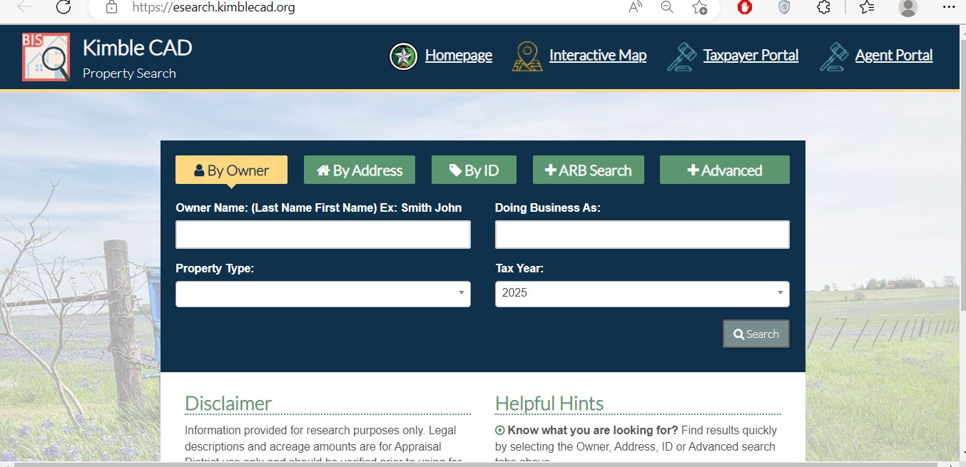
Use the Kimble CAD screenshot to choose the best search tab

Kimble CAD property search showing Owner, Address, ID, ARB Search and Advanced tabs
Existing Kimble CAD search screenshot preserved from the previous article. The live portal may show a newer tax year or slightly different controls.
By Owner: start with last name, then first name.
By Address: use street name or number plus street.
By ID: best for Property ID or Geographic ID.
ARB Search: intended for hearing and protest research.
Advanced: use abstracts, subdivisions, property type and other filters.
What to check after clicking Search: do not rely on the owner name alone. Confirm the Property ID, Geographic ID, abstract or subdivision, acreage and taxing entities.
Advanced lookup

Use Kimble CAD’s specialist search fields for difficult accounts

Advanced fields currently available through the official search
Search field When it helps What to verify
Abstract Rural acreage, ranches and legal descriptions without a normal street address. Abstract name or number, acreage and adjoining tracts.
Subdivision Platted lots, Junction-area subdivisions and repeated street names. Lot, block, phase and recorded plat.
Mobile Home Park Locating manufactured-home accounts connected to a park. Home owner, land owner, serial or title information.
Doing Business As Business personal property or entity-owned accounts. Legal entity, operating name and situs.
Property Type Separating real, business, mineral or other account categories. That you opened the intended account type.
Owner ID Grouping accounts connected to one appraisal owner. Each parcel separately before acting.
Geographic ID Matching the appraisal account with geographic and mapping data. Map location and legal description.
Tax Year Reviewing prior values, exemptions or protest activity. The displayed year before saving evidence.
Protest or hearing fields Researching protest status, informal dates, formal dates or board activity. Current scheduling directly with Kimble CAD.
Parcel and 911 research

Use the interactive map to confirm rural Kimble County property

Open the official interactive map Open Kimble CAD Interactive Map
Locate the account or road Search with the property identifier, owner, address, abstract or nearby road where supported.
Compare neighbouring parcels Check the selected tract’s relationship to highways, ranch roads, rivers, adjoining owners and recorded subdivisions.
Match the appraisal record Confirm that the map parcel connects to the same Property ID, Geographic ID, acreage and legal description.
Use coordinates for a 911 request Kimble CAD’s address form asks for the structure’s latitude and longitude, access road, nearest address or intersection and property ID.
Kimble CAD warns that online legal descriptions and acreage are for appraisal-district use. Verify a deed, field notes, survey or recorded plat before using parcel information in a legal document or boundary decision.
Property-record decoder

Understand what each Kimble CAD field tells you

Use the appraisal account as a research route rather than final legal proof
Account field What it helps identify What it does not prove Next action
Property ID The primary Kimble CAD appraisal account. That every outside collector uses the same number. Save it for office, payment and protest communication.
Geographic ID A geographic parcel reference used with mapping data. A surveyed boundary. Compare it with the interactive map and deed.
Owner shown The owner maintained for appraisal and tax administration. Complete legal title or absence of liens. Use County Clerk records when ownership matters.
Legal description Abstract, survey, tract, lot, block or subdivision information. That the abbreviated description is sufficient for a deed. Verify the recorded instrument and survey.
Acreage The acreage maintained for appraisal purposes. Legally surveyed acreage. Compare the survey and deed field notes.
Land classification Market, agricultural, wildlife, pasture or other appraisal treatment. Current qualification without supporting records. Review the local ag or wildlife guidance.
Improvements Homes, cabins, barns, commercial structures and other appraised improvements. That every size, age or condition entry is correct. Document errors with measurements and photographs.
Taxing entities County, city, school, hospital and groundwater jurisdictions. That Kimble CAD collects every entity’s tax. Check Harper ISD and Mason ISD separately.
Value explanation

Separate market value, appraised value and taxable value

VALUE 1 Market value

Kimble CAD’s opinion of the property’s market value as of January 1 for the appraisal year.

VALUE 2 Appraised value

The value after an applicable appraisal limitation or special-use valuation rule is considered.

VALUE 3 Taxable value

The value remaining after exemptions. It can differ among taxing entities.

Common reasons a Kimble County account changes
Change What to inspect Evidence to prepare
Ranch-land value increased Acreage, location, access, land class and comparable sales. Survey, deed, access limitations and land-sale evidence.
Home or cabin value increased Area, class, age, condition, additions and completion. Measurements, photographs, repair bids and inspection reports.
Taxable value increased Exemption, homestead cap, ownership change and taxing entities. Exemption confirmation and prior-year records.
Ag appraisal disappeared Application, ownership, five-of-seven history, use and intensity. Leases, receipts, livestock, harvest and management records.
Tax bill increased Taxable values, tax rates, penalties and collector history. Appraisal account, tax statement and payment ledger.
Kimble CAD does not set tax rates. The county, city, school districts, hospital district and groundwater districts adopt their own rates.
Notice review

Review the Notice of Appraised Value before deciding whether to protest

Property identity

Confirm the owner, Property ID, Geographic ID, situs address, abstract and legal description.

Market and appraised values

Compare the prior and proposed values and separate land from improvements.

Exemptions and special use

Check homestead, age, disability, veteran, agricultural and wildlife treatment.

Protest deadline

Use the date printed on the individual notice rather than assuming one universal date.

Property characteristics

Review acreage, square footage, structures, condition, use and completion percentage.

Estimated tax information

Treat an estimate as educational because taxing entities adopt rates separately.

Homestead and other exemptions

Apply through Kimble CAD and verify the approved exemption online

Residence homestead

For a qualifying owner’s principal residence. A new purchase does not automatically create the exemption.

Age 65 or older

May provide additional exemptions, school-tax limitations and qualifying payment options.

Disabled person

Review physician or disability documentation and local taxing-unit benefits.

Disabled veteran

Use the appropriate veteran or surviving-spouse application with VA documentation.

Agricultural appraisal

A special land valuation based on qualifying agricultural use rather than a standard residential exemption.

Wildlife management

An alternative open-space use that requires prior qualification, a plan and active management.

Exemption filing workflow

Search the property account Confirm the owner, property ID, address and exemptions already shown.
Open Kimble CAD forms Select the application matching the exemption or special appraisal. Open official forms
Follow the document instructions Prepare identification, ownership, occupancy, age, disability, veteran or land-use evidence required by the form.
Submit through an accepted method Use the current office, mail, portal or other method stated by Kimble CAD.
Preserve proof of submission Save the electronic confirmation, email, certified-mail receipt or stamped copy.
Verify the account after processing Confirm the exemption or special valuation appears for the intended year and taxing entity.
Homestead applications and property profiles are free. Kimble CAD warns residents about official-looking solicitations and states that it does not charge to provide a property profile, homestead application or protest.
Local agricultural appraisal

Understand Kimble CAD’s 1-d-1 agricultural qualification guidance

Important source note: Kimble CAD currently links to a locally adopted agricultural manual dated 2012. Use the principles below as preparation guidance, but confirm current application standards directly with the district before buying land, changing use or filing.
Five-of-seven use history

The published manual states that land generally must have been principally devoted to agriculture for five of the preceding seven years.

Primary use

Agriculture must be the land’s principal use rather than a token, recreational or secondary activity.

Prudent management

The operation should resemble an ordinary, prudent agricultural business in Kimble County.

50-acre local guideline

The local manual states that KCAD adopted a 50-acre minimum guideline and closely examines tracts below 50 acres.

Intensity of use

Land must be stocked, cultivated or managed at a level typical for that agricultural activity.

Evidence burden

The owner is responsible for proving use with leases, receipts, sales, records, photographs and management information.

Published local acreage and intensity examples

These examples are guidance rather than automatic approval
Use Published local example Evidence to prepare
Native pasture or open range Typically 50 acres; local table also shows approximately one cow or bull per 30 acres. Stocking, water, fencing, grazing and livestock records.
Improved pasture Manual describes approximately 20 acres for improved pasture, while the general local minimum remains an important review factor. Grass establishment, brush control, hay, grazing and maintenance records.
Dry cropland Approximately 20 acres planted in small grains or hay under the manual’s example. Seed, fertiliser, planting, harvest and sales documents.
Irrigated cropland Approximately 20 acres actively irrigated under the published example. Water source, irrigation, crop and production records.
Cattle on improved pasture Approximately one animal unit per 7–10 acres of productive land. Herd inventory, sales, veterinary, feed and breeding records.
Cattle on native pasture Approximately one animal unit per 30–40 acres. Stocking records and proof the land can sustain the operation.
Sheep or goats Local manual includes stocking and minimum-herd guidance for sheep and goat operations. Herd count, breeding, sales, grazing and health records.
Horse breeding Published guidance describes a genuine breeding operation rather than recreational horse ownership. Breeding mares, stallion or service records, offspring and sales.
Four-animal-unit test: Kimble CAD’s published manual states that grazing operations typically need a herd capable of meeting at least four animal units and sustaining the land under local conditions.

Application timing and proof

File the 1-d-1 application by April 30 The local manual identifies midnight April 30 as the normal deadline.
Use the limited late-filing period immediately The manual states that a late application may be filed before the ARB approves the appraisal records, usually in July.
Expect a late-filing penalty When a late application is approved, the manual describes a penalty equal to 10% of the tax savings resulting from agricultural appraisal.
Respond to information requests The published manual states that an owner generally has 30 days to provide additional requested information.
New owners should reapply A sale or ownership change requires the new owner to establish qualification and submit a new application.
Protest a denial promptly The local manual states that a denial can be protested to the ARB within 30 days of the denial notice.
Five-of-seven-year land-use history
Current operator and written lease
Livestock, crop or harvest records
Feed, seed, fertiliser and veterinary receipts
Fencing, water and brush-control records
Dated photographs of active use
Map separating homesite and productive acreage
Income, sales or Schedule F documentation where useful
Wildlife-management appraisal

Convert qualifying open-space land to active wildlife management

Wildlife management is not created merely by owning hunting land. Kimble CAD’s published policy requires qualifying prior open-space treatment, a written plan, active management and supporting records.
Core requirements in Kimble CAD’s published wildlife policy
Requirement Published local guidance Practical evidence
Prior qualification Land generally must have qualified for agricultural or wildlife appraisal in the previous tax year. Prior appraisal account and special-use approval.
Primary use Wildlife management—not residential or recreational use—must be the primary land use. Plan, implementation calendar and annual records.
Three of seven activities At least three statutory wildlife-management activities must be performed. Photographs, receipts, logs, maps and census records.
Stand-alone acreage Published policy identifies a 50-acre minimum for a stand-alone tract. Appraisal map, deed, survey and acreage calculation.
Association or co-op Policy identifies a 20-acre minimum per owner in qualifying association or co-op circumstances. Written association agreement and contiguous-property records.
Species of concern Policy identifies a 20-acre minimum for the published species-of-concern route. Target-species documentation and regional management guidance.
Plan and inspection KCAD reviews the plan, maps, photographs and receipts and may schedule an onsite inspection. Complete plan, implementation records and site access.

The seven wildlife-management activity categories

Habitat control

Improve or preserve habitat for the target species.

Erosion control

Use practices that reduce erosion for wildlife benefit.

Predator control

Manage predators when necessary for the target population.

Supplemental water

Provide water beyond naturally available sources.

Supplemental food

Provide food or nutrition in addition to natural forage.

Shelter

Create or maintain nesting, breeding and escape cover.

Census counts

Measure wildlife populations and management results.

Record keeping

Document dates, activity, expense and observed outcome.

Updated records matter: the published policy states that wildlife updates may be required every three years or when the intensity of management is questioned.
2026 appraisal protest

File the Kimble CAD protest before the deadline, then improve the evidence

Normal deadline: May 15 or 30 days after the Notice of Appraised Value was delivered, whichever is later. The date printed on the individual notice controls.
Save the notice and property account Preserve the property ID, legal description, land, improvements, exemptions and proposed values.
Identify the exact protest ground Examples include market value, unequal appraisal, incorrect property characteristics, exemption denial, ag denial or ownership error.
Open the electronic appeal portal Kimble CAD states that some property types can file electronically and that a separate appeal is required for each property. Open Kimble CAD Taxpayer Appeals
Use a paper protest when needed Download the Notice of Protest form and deliver or mail it through an accepted method.
Preserve proof of filing Save the portal confirmation, email, fax record, certified-mail receipt or stamped copy.
Request the district’s evidence Review appraisal data, sales, land schedules and property characteristics before the hearing.
Attempt an informal resolution Present concise evidence to the appraiser and ask whether a factual correction or value agreement is possible.
Prepare for the ARB Number the pages, put the requested outcome first and bring or submit every supporting document.

Evidence that can help a Kimble County protest

Notice of Appraised Value
Saved Kimble CAD property record
Comparable sales with meaningful adjustments
Unequal-appraisal account comparisons
Dated property-condition photographs
Repair estimates and professional reports
Survey, acreage or improvement measurements
Agricultural or wildlife-use records
One-paragraph protest statement
I am protesting Kimble CAD property ID [number] for tax year 2026 because [market value / unequal appraisal / factual error / exemption or special-appraisal issue]. The account currently shows [disputed fact or value]. I request [specific correction or target value], supported by the attached [sales, photographs, estimates, measurements or land-use records].
Avoid unsupported promises that “most protests win.” Results depend on the account, evidence, legal protest ground and ARB determination.
Appraisal Review Board

Present a short, organised case to the Kimble County ARB

Independent citizen board

The ARB hears unresolved disputes between property owners and the appraisal district.

Specific request

State the value, exemption, classification or factual correction you want.

Numbered evidence

Label every photograph, comparable, estimate and land-use record.

Remote options

Confirm whether phone, video, affidavit or in-person participation is available for the scheduled hearing.

Agent appointment

Use the official agent form when another person will represent the property owner.

Written order

Save the ARB order and review any arbitration or court deadline immediately.

Five-part presentation order

Identify the property State the Property ID, owner, location and protest reason.
Correct factual errors Address acreage, structures, condition, use, exemptions or agricultural classification.
Show the strongest evidence Explain the most relevant sales, estimates or operational records.
Respond to CAD evidence Identify why a comparable, land class or property characteristic does not match.
Repeat the requested outcome End with one clear value or account correction.
Tax statements and payments

Pay Kimble CAD-collected taxes through the verified property account

The official Kimble CAD property-search cart states that taxpayers can locate a property and select the green Pay Taxes button to complete a secure card transaction.
Open the official property search Open Kimble CAD Property Search
Locate the correct property Search by Property ID when possible and confirm the owner, legal description and tax year.
Review the taxing entities Confirm whether the bill includes Kimble County, City of Junction, Junction ISD, hospital or groundwater entities.
Select the green Pay Taxes button Add the intended account or accounts to the payment cart.
Confirm the live balance Check current and delinquent years, penalty, interest, partial payments and the total amount selected.
Read the processing fee The secure payment provider may charge a transaction fee. The checkout screen controls.
Save the receipt Record the property ID, taxing entities, year, amount, fee, payment date and confirmation number.
Recheck the account Confirm that payment posted to the intended property and year after processing.
Multiple properties: the Kimble CAD cart states that the online payment feature can work with multiple properties. Verify every account before submitting one combined transaction.
Never pay using account information copied only from a third-party website. Begin in the official Kimble CAD search and compare the property ID and taxing entities before entering card details.
Outside school-tax collection

Check Harper ISD and Mason ISD taxes separately

Kimble CAD’s official homepage lists Harper ISD and Mason ISD among the entities for which it provides appraisal values but does not collect taxes.

Property is in Junction ISD Review the Kimble CAD property account and payment route because Junction ISD is listed among the local entities served through Kimble CAD.
Property is in Harper ISD Use the taxing-unit name or code from the account and contact the current Harper ISD collector before paying.
Property is in Mason ISD Use the Kimble CAD appraisal value, but verify the current Mason ISD collection portal or tax office separately.
Property crosses a district boundary Match each parcel and taxing entity separately rather than assuming one bill covers all acreage.
Payment-safety rule: the entity name on the live tax statement determines where payment belongs. Save a separate receipt when an outside school collector is involved.
Mailing and 911 address help

Use Kimble CAD’s dedicated correction forms instead of a vague request

Change the mailing address

The online address-change form asks for the owner name, old address, new address, Property ID, date, email, phone and digital signature.

Open mailing-address change form
Request, verify or change a 911 address

The 911 form asks for the property ID, road accessed, nearest neighbour or intersection, coordinates, property type and subdivision or tract details.

Open 911 address request

Prepare these details for a 911 request

Kimble CAD Property ID
Property owner name
Road used to access the driveway
Nearest neighbour or intersection
Latitude and longitude of the structure
City-limit or unincorporated status
Residence, business or farm/hunting use
Subdivision, tract or additional location information
Kimble CAD’s homepage directs 911-addressing questions to Josephine at (325) 446-3717 or jyoungdoff@kimblecad.org.
Recorded ownership documents

Use the Kimble County Clerk for deeds, liens and real-property records

Open the County Clerk page Open Kimble County Clerk
Choose the official public-record search The Clerk provides links to county and court record-search systems.
Search grantor and grantee names Try the current owner, former owner, spouse, estate, trust and entity names.
Compare the legal description Match the abstract, survey, tract, lot, block and acreage with the Kimble CAD account.
Review the instrument chain Look for deeds, deeds of trust, releases, liens, affidavits and other relevant documents.
Order the correct copy Ask whether a plain or certified copy is required and verify current fees.
Photo identification is required for real-property recording under the Clerk’s published notice effective September 1, 2025. Confirm the acceptable identification and document requirements before travelling.
The appraisal owner is not a title opinion. Use a title company or qualified Texas lawyer when clear title, easements, access, liens or mineral ownership must be determined.
Bulk records and technical research

Use Kimble CAD downloads when one property page is not enough

Certified appraisal rolls

Download prior certified appraisal-roll files for database and historical research.

2026 preliminary values

KCAD provides a 2026 preliminary-value file excluding industrial and mineral accounts.

Mineral rolls

Separate mineral-roll downloads are available for selected years.

Mass appraisal reports

Review methodology and annual appraisal reporting for broader value research.

Parcel GIS files

Kimble parcel downloads require compatible GIS software and technical knowledge.

Depreciation schedules

The tax-information page includes a published 2026 depreciation schedule.

Do not automate or scrape the public search without permission. The portal’s terms restrict unauthorised data scraping and commercial use. Use the district’s published download files for bulk research.
Troubleshooting

Fix common Kimble CAD search, tax and land-record problems

Try the next practical route before assuming the record is unavailable
Problem Likely reason Best fix
Owner search finds nothing Name order, estate, trust, spouse or entity differs. Search surname only, DBA, Property ID or Geographic ID.
Ranch-road address fails The appraisal situs, mailing address and 911 address may differ. Use street name only, abstract, owner or property ID.
Acreage appears incorrect CAD acreage is maintained for appraisal use or a split is processing. Compare the deed, survey and map; contact CAD with documents.
Former owner still appears The recorded deed may not yet have updated the appraisal record. Confirm recording with the County Clerk and provide the deed to CAD.
Pay Taxes button is missing The account, year or taxing entity may not be collected through Kimble CAD. Check the taxing entity and contact the district before paying.
Harper or Mason school tax is absent Kimble CAD states that it does not collect those school taxes. Contact the applicable school collector with the bill and account.
Ag appraisal was denied Acreage, use history, intensity, current use or evidence may be insufficient. Read the denial, gather records and file a timely protest.
Wildlife plan is incomplete The plan may lack target species, activities, schedule, maps or evidence. Complete all required sections and organise implementation records.
DMV service is unavailable The shared office does not guarantee DMV availability every day. Call (325) 446-3717 before travelling.
Prepared Kimble CAD call script
I am calling about Property ID [number] / Geographic ID [number] at [address, abstract or legal description] for tax year [year]. The account currently shows [owner, value, acreage, exemption or taxing entity]. I need help with [one exact issue]. I have the notice and supporting document available.
Important action dates

Kimble County appraisal and tax calendar

Appraisal and qualification date Ownership, condition, use and qualification for many exemptions are generally determined as of January 1.
Normal rendition deadline Business-personal-property owners should file or request an available extension by the controlling deadline.
Normal agricultural and exemption target date Kimble CAD’s published ag manual identifies April 30 for timely 1-d-1 filing.
Normal protest date File by May 15 or 30 days after notice delivery, whichever is later.
Appraisal-roll approval period Late agricultural filing ends before ARB approval of the records, subject to current law and local processing.
Tax statements generally begin Kimble CAD announced that 2025 statements were mailed in November 2025; verify the current year’s mailing date online.
Normal tax-payment deadline Follow the date printed on the bill and verify weekend, holiday or late-bill rules.
Kimble CAD closes at 3:00 PM on the working day before a scheduled county holiday. Check the holiday schedule and call before delivering a deadline-sensitive filing.
Verified local contacts

Kimble County appraisal, collection and deed-record offices

Kimble Central Appraisal District
509 College Street
Junction, Texas 76849
Mailing: P.O. Box 307, Junction, Texas 76849-0307

(325) 446-3717
Secondary published number: (325) 446-2357
Fax: (325) 446-4361
General email: kcad@kimblecad.org

Hours: Monday-Thursday 8:00 AM-5:00 PM; Friday 8:00 AM-4:00 PM.

Chief Appraiser: Kenda McPherson, RPA, RTA

Kimble CAD staff contacts

Deputy Chief: Clarissa Teichman
Office Manager: Elissa Hooper
Senior Appraiser: Tom Shirley
Clerk / 911 assistance: Josephine Youngdoff

911 email: jyoungdoff@kimblecad.org

Kimble County Tax Assessor-Collector

Tax Assessor-Collector: Matthew Suttle

509 College Street
Junction, Texas 76849
Mailing: P.O. Box 307, Junction, Texas 76849-0307

(325) 446-3717
matt.suttle@co.kimble.tx.us

The Comptroller directory states that this county tax office does not collect property taxes.

Kimble County Clerk

County Clerk: Karen E. Page

105 Reid Road
Junction, Texas 76849

(325) 446-3353
Fax: (325) 446-2986

Use the Clerk for real-property recording, deeds, liens, certified copies and official records.

Kimble CAD contact form

The official form asks for the requester’s name, phone, email, Property ID when available and a clear message.

Open contact form
Accessibility and interpreters

KCAD’s published policy asks a person needing additional access assistance or an interpreter for a meeting to notify the chief appraiser at least two business days beforehand.

Accessible parking is identified at the district office.

DMV travel warning: Kimble CAD asks visitors to call (325) 446-3717 before travelling for vehicle title, registration or other DMV business.
Official action links

Official Kimble County appraisal, tax and land-record resources

Kimble CAD homepage

Official notices, office details, tax information and local policies.

Open Kimble CAD
Property search

Search owner, address, Property ID, Geographic ID, abstract and advanced fields.

Search property records
Taxpayer portal

Access property details, documents, applications and electronic communications.

Open taxpayer portal
Online protest

File a separate electronic appeal for each eligible property.

Open taxpayer appeals
Interactive map

Check rural parcel location, abstract context and adjacent properties.

Open parcel map
Forms

Homestead, veteran, ag, wildlife, rendition, protest and agent forms.

Open Kimble CAD forms
Tax information

Annual reports, reappraisal plan, rates, depreciation schedules and tax guidance.

Open tax information
Downloads

Certified rolls, preliminary values, mineral rolls, GIS parcels and mass-appraisal reports.

Open downloads
County Clerk records

Find recorded deeds, liens, filing information and official record-search links.

Open Kimble County Clerk
Editorial accountability

How this Kimble County guide was rebuilt

Mahesh Kumar, editor of AppraisalDistrict.org

Existing article images preserved with deeper local guidance

This regenerated version preserves the original Kimble CAD search screenshot and editor image while replacing the earlier short article with complete property-search instructions, advanced-field guidance, parcel verification, tax-collection routing, 911 addressing, agricultural and wildlife standards, protest preparation, payment steps, deed research and official contact information.

The official review included Kimble Central Appraisal District, Kimble CAD property search, Taxpayer Portal, taxpayer and agent appeal portals, Kimble County government, Kimble County Clerk and the Texas Comptroller’s county property-tax directory.

AppraisalDistrict.org is an independent informational website and is not operated by Kimble Central Appraisal District, Kimble County or any taxing unit.

Kimble County answers

10 common Kimble County Appraisal District questions

1. How do I search Kimble County property records?

Use the official Kimble CAD property search. Search by Property ID, Geographic ID, owner name, street address, abstract, subdivision or advanced filters, then verify the legal description, acreage and taxing entities.

2. Does Kimble CAD collect property taxes?

Kimble CAD provides tax-payment support and collects for several local entities. Its official homepage states that it does not collect Harper ISD or Mason ISD taxes and provides appraisal values only for those districts.

3. How do I pay Kimble County property taxes online?

Locate the property in the official Kimble CAD search and select the green Pay Taxes button when it is available. Confirm the property, taxing entities, tax year, balance, fee and receipt before completing payment.

4. What is the Kimble CAD protest deadline for 2026?

The normal Texas deadline is May 15 or 30 days after the appraisal notice was delivered, whichever is later. The exact date printed on the individual notice controls.

5. Can I protest a Kimble County appraisal online?

Yes. Use the Kimble CAD taxpayer-appeal portal for an eligible property. File a separate appeal for each property and preserve the confirmation.

6. How do I apply for a Kimble County homestead exemption?

Open Kimble CAD’s official forms page, complete the residence-homestead application, attach the required ownership, occupancy and identification information, submit it through an accepted method and later verify the exemption in the property account.

7. What is Kimble CAD’s agricultural acreage guideline?

Kimble CAD’s published agricultural manual uses a 50-acre local guideline and states that tracts under 50 acres are closely examined. Acreage alone is not enough; use history, primary use, intensity, livestock or production evidence and prudent management also matter.

8. What are Kimble CAD wildlife-management requirements?

The published policy generally requires prior open-space qualification, a wildlife-management plan, at least three of seven qualifying activities and compliance with applicable acreage and use standards. Confirm current requirements with KCAD before filing.

9. Where can I search Kimble County deeds and liens?

Use the Kimble County Clerk page and its official record-search options. The appraisal owner name does not replace a recorded deed or title examination.

10. Where is Kimble Central Appraisal District located?

Kimble CAD is located at 509 College Street, Junction, Texas 76849. Call (325) 446-3717. Published hours are Monday-Thursday 8:00 AM-5:00 PM and Friday 8:00 AM-4:00 PM.

Leave a Comment