Search, Verify and Act on a Hutchinson County Property Account
Start with Hutchinson County Appraisal District when you need a parcel ID, geographic ID, owner shown for appraisal purposes, property address, legal description, abstract, subdivision, acreage, value, exemption, mineral account or taxing-unit information.
Do not use the appraisal record as a tax receipt or title report. Use the Hutchinson County Tax Assessor-Collector for the live bill and payment, and use the County Clerk for recorded deeds, liens, releases and certified land records.
Use the parcel ID or geographic ID when available.
920 Illinois Avenue, Borger, Texas 79007.
Local portals and procedures reviewed July 2026.
What do you need from the Hutchinson County property record?
Use owner, parcel ID, geographic ID, address, legal description, abstract or subdivision.
Follow the search stepsSearch the lease name, lease number, owner, property ID and correct tax year.
Review mineral-account guidanceConfirm the property, year, balance, payment fee and receipt before submitting.
Use the payment workflowIdentify the exact value, exemption or property-data problem before filing.
Build a focused protestPrepare identification, property details and qualification evidence before submitting.
Review exemption stepsThe appraisal owner entry does not replace a deed or title examination.
Verify deeds and liensSearch Hutchinson County property records without opening the wrong account
Use the Hutchinson CAD search screen shown below
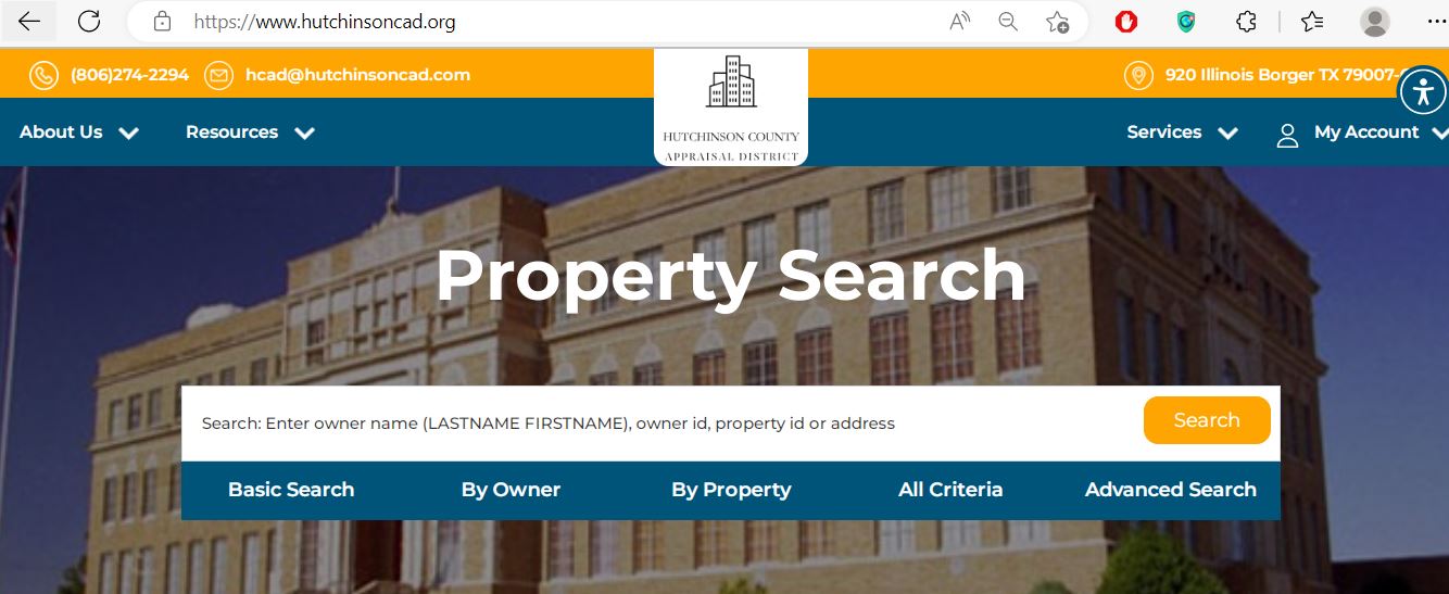
Choose the search field that matches the Hutchinson County property type
| Search field | Best use | Practical tip |
|---|---|---|
| Parcel or property ID | Reopening one exact appraisal account. | Copy it from the notice, prior record or tax statement. |
| Geographic ID | Matching the account to geographic or legal parcel information. | Enter the complete identifier exactly as displayed. |
| Owner ID | Finding accounts tied to a known appraisal owner. | Do not confuse owner ID with property ID. |
| Legal description | Finding rural tracts or property without a standard address. | Enter a distinctive portion rather than the complete description. |
| Abstract | Locating land identified by a survey or abstract. | Confirm the abstract from a deed or prior account. |
| Subdivision | Finding lots in Borger, Fritch, Stinnett, Sanford or another platted area. | Compare lot, block and property address. |
| Lease name | Searching oil, gas or mineral interests. | Try a shortened name when punctuation or spacing differs. |
| Lease number | Finding an exact mineral or operator-related account. | Use the number from the mineral notice or prior record. |
| Land acres | Narrowing rural and open-space property results. | Use a range rather than assuming CAD acreage equals surveyed acreage. |
| Value search | Researching groups of accounts within a market-value range. | Useful for protest comparison, not for identifying ownership by itself. |
Use the interactive map before relying on a street or lease match
Understand the important fields inside a Hutchinson CAD account
| Field | What it tells you | What it does not prove | Next action |
|---|---|---|---|
| Parcel ID | The appraisal account identifier used by Hutchinson CAD. | That another office uses the same number. | Save it and compare it with the tax record. |
| Geographic ID | A geographic or legal reference connected to the parcel. | A surveyed boundary. | Compare it with the map and deed. |
| Owner | The owner carried for appraisal and taxation. | Clear title or complete ownership history. | Search recorded County Clerk documents. |
| Legal description | The lot, block, abstract, tract, lease or other legal reference. | That the abbreviated description is sufficient for legal use. | Compare it with the recorded deed or lease documents. |
| Category code | CAD’s classification of the property or account. | That the classification or use is correct. | Question an incorrect real, mineral, personal or exempt category. |
| Market value | CAD’s opinion of market value as of January 1. | A guaranteed sale price or final tax bill. | Compare sales, condition and equal-appraisal evidence. |
| Ag or timber value | A productivity value applied to qualifying land. | Continued qualification after a use change. | Review acreage, use history and application status. |
| Homestead cap loss | The amount excluded from appraised value by an applicable homestead limitation. | That the market value itself was reduced. | Compare market, appraised and taxable values separately. |
| Circuit-breaker loss | An applicable limitation on appraised value for qualifying non-homestead real property. | An exemption or permanent value reduction. | Review the account year and qualification rules. |
| Deed history | Recording references used during CAD ownership processing. | Clear title or the absence of liens. | Open the original County Clerk records. |
Move from market value to the taxable value for each local entity
Hutchinson CAD’s opinion of market value as of January 1 for the tax year.
The value after an applicable homestead cap, circuit-breaker limitation or productivity appraisal.
The value remaining after applicable exemptions for a particular taxing unit.
Fix a Hutchinson CAD property search that returns no result
| Problem | Likely reason | Practical fix |
|---|---|---|
| Owner name returns nothing | The portal uses LASTNAME FIRSTNAME or the account belongs to a trust, estate or company. | Search the last name only or one distinctive organisation word. |
| Address is not recognised | The address may use an abbreviated road, old city format or no normal situs address. | Search the street name only, then use ID, legal, abstract or subdivision. |
| Mineral account is missing | The account may be under a lease name, lease number, operator or separate mineral owner. | Select Mineral Property and search lease, owner ID or property ID. |
| Business account is missing | The account may be classified as personal property rather than real property. | Change the property-type filter and search the business owner or account number. |
| Recently purchased property shows the seller | The recorded deed may still be processing into the appraisal roll. | Confirm recording and provide CAD with the instrument information. |
| Several similar land accounts appear | The owner may hold adjacent tracts or separate surface and mineral interests. | Compare every parcel ID, geographic ID, legal description and acreage. |
| Wrong tax year is displayed | The search retained a prior-year selection. | Change the year before relying on values, exemptions or protest status. |
| Tax balance does not match CAD | CAD and Tax Office systems serve different purposes. | Compare the property account, tax year, exemptions, payments and penalties. |
Use specialised searches for Hutchinson County energy and personal-property accounts
Search mineral property using lease name, lease number, owner ID, property ID, legal description and tax year.
The surface parcel and mineral interest can have different owners, property IDs and taxable values.
Hutchinson CAD states that mineral, utility and industrial accounts are appraised for the district by Pritchard & Abbott.
Residential, commercial and other real-property accounts are appraised locally by Hutchinson CAD.
Search the business owner and Personal Property filter, then review rendition and depreciation information.
One lease can create numerous fractional-interest accounts. Match the owner, decimal interest, lease and tax year.
Review the notice, ownership documentation and effective date before asking CAD to change a mineral owner.
Confirm whether the tax account uses the same parcel number displayed by CAD before paying.
Businesses should keep asset descriptions, acquisition dates, costs, condition and prior-year rendition information.
Send each Hutchinson County property question to the right office
| Need | Correct office | Prepare first |
|---|---|---|
| Property value or appraisal method | Hutchinson County Appraisal District | Parcel ID, tax year, notice and evidence. |
| Homestead or other exemption | Hutchinson County Appraisal District | Application, identification and qualification date. |
| Agricultural special appraisal | Hutchinson County Appraisal District | Acreage, use history, maps and production evidence. |
| Mineral, utility or industrial appraisal | Begin with Hutchinson CAD | Owner, lease, operator, property ID and tax year. |
| Tax bill, balance or receipt | Hutchinson County Tax Assessor-Collector | Account, owner, tax year and payment information. |
| Recorded deed, lien or release | Hutchinson County Clerk | Grantor, grantee, date, legal description or instrument number. |
| Tax-rate or budget question | The individual taxing unit | Taxing-unit name and tax-transparency information. |
| Legal parcel or mineral boundary | Surveyor, title company or qualified attorney | Deeds, plats, leases, CAD map and title documents. |
Correct the record that controls the inaccurate information
Use the correct Hutchinson CAD application and retain proof
Complete the official application and include a colour copy of the required driver licence or other information required by the form.
Additional affidavits may be required when the ownership or identification situation does not follow the standard application path.
Use the official veteran exemption application and attach the required VA evidence.
Use the 1-d-1 application and prepare land-use history, acreage, maps and production evidence.
Use the business-personal-property rendition for taxable furniture, equipment, machinery, inventory and other assets.
Review the official rendition form when reporting property information under the applicable Texas rules.
Application preparation checklist
Prepare a Hutchinson County protest around one clear issue
Practical evidence checklist
Check Hutchinson County protest and hearing information
Hutchinson CAD provides a public protest-hearing search that can filter past hearings, future hearings and open protests.
Move from the appraisal account to the Hutchinson County tax ledger
Hutchinson CAD can display taxing units, rates and base-tax information, but the Tax Assessor-Collector controls the official bill, payment status, receipt and delinquent balance.
Follow proposed tax rates separately from appraisal value
Use Hutchinson County Clerk records when title or liens matter
| Item | Published detail | Practical note |
|---|---|---|
| First page of real-property recording | $25 | Verify the current fee before filing. |
| Each additional page | $4 | Additional indexing charges may apply. |
| Names above the included indexing limit | $0.25 per additional name | Ask the Clerk to confirm the total. |
| Transfer-of-property identification | Photo identification is required under the Clerk’s published filing notice. | Confirm acceptable identification before visiting. |
Use Hutchinson CAD certified rolls and reports for deeper research
The Data and Records section publishes certified appraisal rolls, spreadsheets, mineral-roll files, depreciation schedules, low-income-housing rates and utility reports.
Available in geographic-order PDF, alphabetic-order PDF and spreadsheet formats for published years.
Separate mineral-roll downloads are available for selected years.
Useful when researching business-personal-property appraisal and rendition questions.
Annual materials are published for qualifying property research.
The district publishes utility-usage reports as part of its transparency resources.
The property-search results page can display and download selected account columns.
Request eligible Hutchinson CAD notices by email
Hutchinson CAD publishes an electronic-communications form for eligible notices involving a qualifying owner-occupied residence.
Important Hutchinson County appraisal and tax dates
Hutchinson County property offices and where to visit
Borger, Texas 79007-6112
Phone: (806) 274-2294
Fax: (806) 273-3400
Email: hcad@hutchinsoncad.com
Hours: Monday-Thursday, 8:00 AM-5:00 PM; Friday, 8:00 AM-12:00 PM.
Chief Appraiser: John Gillman
Stinnett, Texas 79083
Mailing: P.O. Box 989, Stinnett, Texas 79083-0989
Phone: (806) 878-4005
Fax: (806) 878-4008
Email: ckimmell@hutchinsoncnty.com
Tax Assessor-Collector: Carrie Kimmell
Main Stinnett and Borger hours: Monday-Thursday, 8:00 AM-6:00 PM.
Stinnett, Texas 79083
Mailing: P.O. Box 1186, Stinnett, Texas 79083-1186
Phone: (806) 878-4002
Fax: (806) 878-3497
Hours: Monday-Thursday, 8:00 AM-6:00 PM.
County Clerk: Kelly Ratliff
Published County Tax Office hours differ by weekday and include a midday closure.
Confirm the current Fritch schedule by phone before travelling.
Verify current branch hoursOfficial Hutchinson County property resources
Search owner, property, address, legal, lease, acreage and value fields.
Open Hutchinson CADConfirm parcel location and neighbouring appraisal accounts.
Open the CAD mapFind homestead, veteran, agricultural, rendition and electronic-notice forms.
Open CAD formsUse the official electronic protest route for eligible properties.
Open online protestRequest the unique PIN used for eligible online property services.
Request a PINSearch past, future and open appraisal protests.
Search hearingsDownload certified appraisal rolls, spreadsheets and mineral-roll files.
Open data and recordsSearch official bills, balances and property-tax payment options.
Open tax paymentsHow this Hutchinson County guide was rebuilt

Existing images preserved and official workflows expanded
This regenerated guide retains the Hutchinson CAD search screenshot and editor image from the existing article while replacing the earlier short guidance with detailed search steps, map verification, property-field explanations, mineral and business-account help, exemption preparation, protest filing, tax-payment verification, deed research and public-data instructions.
The official review included Hutchinson County Appraisal District, Hutchinson County Tax Assessor-Collector, Hutchinson County Clerk, the Texas Comptroller directory, certified appraisal-roll resources and local tax-transparency guidance.
AppraisalDistrict.org is an independent informational website and is not operated by Hutchinson County Appraisal District or Hutchinson County.
10 common Hutchinson County Appraisal District questions
1. How do I search Hutchinson County property records?
Open the official Hutchinson CAD website. Search by owner, property ID, geographic ID or address, or use All Criteria and Advanced Search for legal, abstract, subdivision, lease, acreage and value fields.
2. How should I enter an owner name in Hutchinson CAD?
Enter a person as LASTNAME FIRSTNAME. When the complete name fails, try the last name only, a trust or estate name, or one distinctive business-name word.
3. Why does a Hutchinson CAD address search return no result?
The account may use an abbreviated road, rural description, subdivision, legal description or no standard situs address. Try the property ID, geographic ID, owner, abstract, subdivision or interactive map.
4. Does Hutchinson County Appraisal District collect property taxes?
No. Hutchinson CAD appraises property and handles exemptions and protests. The Hutchinson County Tax Assessor-Collector handles bills and payments.
5. Can I search Hutchinson County mineral property?
Yes. Select the mineral-property type and search by lease name, lease number, owner ID, property ID, legal description or tax year.
6. How do I apply for a Hutchinson County homestead exemption?
Download the application from the Hutchinson CAD forms page, attach the required colour identification copy or other documentation, submit it to the district and retain proof.
7. How do I protest a Hutchinson County appraisal value?
Open the property account, save the appraisal notice, identify the exact issue, use the File a Protest link or official online-protest route, file by the deadline printed on the notice and retain confirmation.
8. Where do I pay Hutchinson County property taxes?
Start from the County Tax Assessor-Collector page or use the official property-tax payment portal. Confirm the property, year, balance and fee before paying.
9. Does the Hutchinson CAD owner name prove legal ownership?
No. The CAD owner entry supports appraisal and taxation. Use recorded County Clerk deeds and professional title research when legal ownership or lien status matters.
10. Can Hutchinson CAD acreage or map lines be used as a legal boundary?
No. Hutchinson CAD states that acreage and legal descriptions should be verified before legal use. Obtain the recorded deed, plat and professional survey.