Freestone CAD See Freestone County Appraisal District 2026

Freestone County, Texas · Property search, ag and timber land, minerals, exemptions, protests and tax payment

Navigate Freestone CAD Records From First Search to Verified Next Step

Freestone County records can include homes, rural acreage, agricultural and timber land, mineral interests, manufactured housing, business assets and properties divided among school or city jurisdictions.

This guide shows how to use every official search tab, understand the property result, find a tract without a normal address, prepare exemption or special-appraisal forms, build a protest, confirm the correct tax collector and locate deeds or liens through the County Clerk.

Property or owner ID Owner surname Street or rural location Abstract or legal description Property type Appraisal notice
FREESTONE PARCEL COMPASS ROUTING PROPERTY RECORD
CAD SEARCH OWNER · ID · LEGAL
VERIFIED PROPERTY RECORD
OFFICE MATCHED
TYPE + YEAR + ACCOUNT VERIFIED
Do not use the CAD value page as a tax-payment receipt. Freestone CAD handles appraisals, exemptions, property descriptions, maps and protests. The Freestone County Tax Assessor-Collector handles tax balances, online payments, receipts, penalties, interest and collection questions.
Five search modes

Basic, owner, property, all-criteria and advanced searches.

Latest published rates

Official CAD page currently displays tax-year 2025 rates.

Chief appraiser

Don Awalt, RPA, CTA and CCA.

CAD telephone

903-389-5510 for appraisal-record assistance.

Official review

Portals and local contacts checked July 28, 2026.

Start with the right property route

What are you trying to resolve in the Freestone County record?

This browser helper runs locally and does not transmit an owner name, address, property ID or appraisal information.

PROPERTY LOOKUP Search Freestone CAD

Find owner, property ID, values, exemptions, acreage, legal description and taxing entities.

Follow the search walkthrough
RURAL OR AG LAND Use Advanced Search and map

Abstract, geographic ID, legal description and acreage can work better than an address.

Prepare rural-land records
VALUE OR EXEMPTION Use the appraisal district

Freestone CAD controls appraisal value, property characteristics and exemption processing.

Decode the appraisal values
TAX BILL OR RECEIPT Use the Tax Office

Search the collection record and confirm every taxing entity and tax year before paying.

Use the payment checklist
PROTEST OR ARB Use online protest access

Register, obtain the property PIN when needed and preserve the filing confirmation.

Build a protest file
DEED OR LIEN Use the County Clerk

The CAD owner display is not a substitute for a recorded deed, lien or plat.

Search official documents

Go directly to the Freestone County property task

The search and screenshot sections help identify the account. Later sections cover appraisal values, rates, exemptions, agricultural or timber use, protests, payment and recorded documents.

Existing article image retained

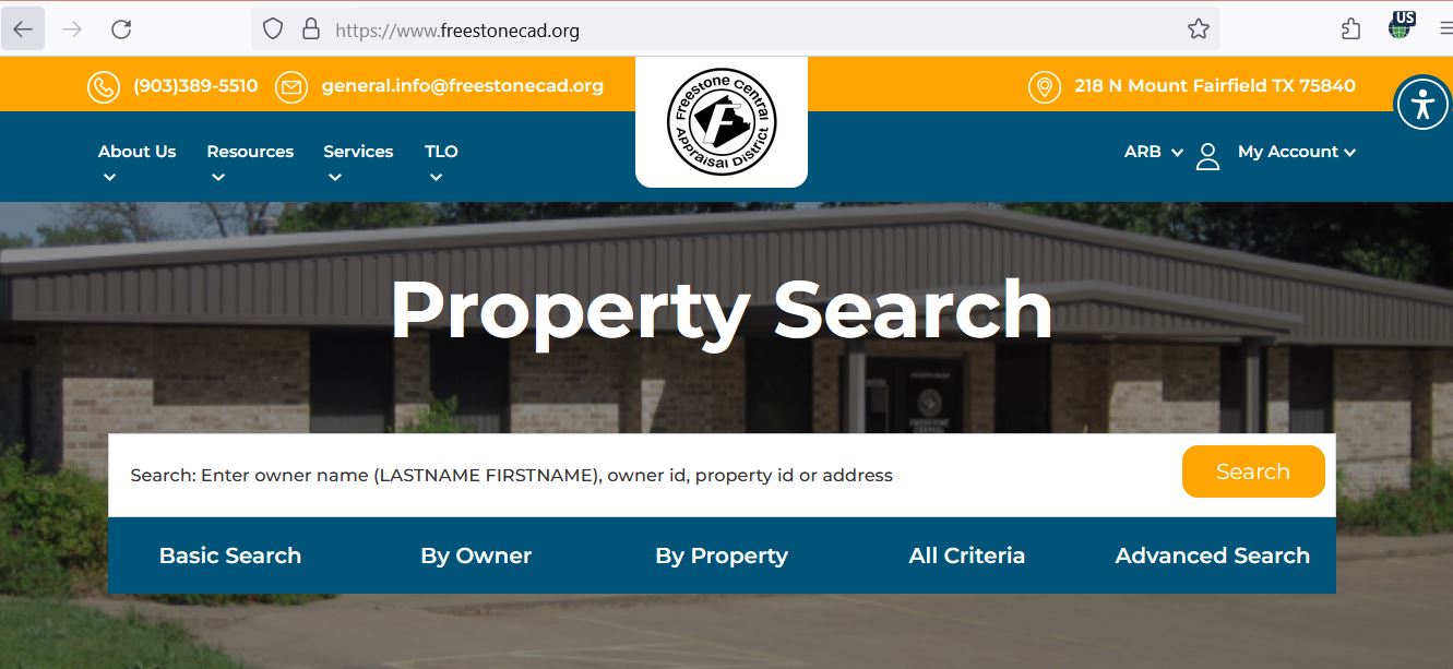
Use the Freestone property-search screenshot as a click guide

Freestone Central Appraisal District property search showing the search bar and five search tabs
Screenshot retained from the existing article. It shows the official Freestone CAD search bar and the Basic Search, By Owner, By Property, All Criteria and Advanced Search tabs. Portal wording or layout may change after this guide is reviewed.
1 Search bar Enter a surname, owner ID, property ID or shortened address.
2 Basic Search Start here when you have one strong identifying detail.
3 By Owner Use surname-first formatting and fewer words when the full name fails.
4 By Property Use property ID, geographic ID, legal description, abstract or lease details.
5 Advanced Search Use acreage, value, category and other filters for research across several accounts.
Privacy-safe research: Avoid sharing screenshots containing owner mailing addresses, property IDs, account PINs, payment details or other personal information unless it is necessary for the office handling the issue.
Property-result decoder

Understand what the appraisal record does—and does not—prove

Use each field to choose the next official record
Field What it helps identify What it does not prove Next action
Property ID The appraisal account connected to the displayed taxable property. That adjacent land, minerals or another improvement are included. List every related property ID separately.
Owner name The owner currently displayed for appraisal administration. Complete legal title or every ownership interest. Compare the recorded deed or probate documents.
Geographic ID A location-based identifier useful for parcel and map research. A surveyed boundary or legal ownership. Match it with the map, deed and survey.
Legal description The abstract, survey, tract, subdivision, lot or block used in the appraisal record. That abbreviated CAD wording is sufficient for a legal instrument. Read the complete recorded deed or plat.
Acreage The acreage used for appraisal administration. Surveyed acreage, fence position or access rights. Use a licensed surveyor when precision matters.
Category or property type Residential, agricultural, timber, commercial, mineral or another appraisal classification. That every related account uses the same classification. Search all relevant property types.
Market value The district’s estimate of market value for the displayed appraisal year. Taxable value, purchase price or tax due. Compare appraisal limits and exemptions.
Appraised value The value after an applicable cap, limitation or special appraisal. That the market value is correct or cannot be protested. Review market and appraised values separately.
Exemptions Benefits shown for the appraisal account. That every taxing unit grants the same amount. Review taxable value for each entity.
Taxing entities The county, city, school or hospital districts associated with the account. That every entity uses one collector or one taxable value. Match the final tax statement and collection record.
Search troubleshooting

Fix a Freestone CAD search that returns no useful result

Remove the most likely search obstacle first
Problem Likely reason What to try
Full owner name fails Surname-first format, initials, spouse, trust, estate or company suffix. Search the surname or main business word only.
Address search fails County-road wording, highway format, rural route, abbreviation or no ordinary situs address. Use the street name, property ID, owner, abstract, legal description or map.
Rural tract is unclear The land may be indexed by abstract, survey, geographic ID or a larger legal tract. Use By Property or Advanced Search and compare the interactive map.
Mineral account is missing The interest may use another owner, lease, operator, agent or separate account. Use the mineral property type, lease name, lease number and owner variations.
Business account is missing The record may use a DBA, legal entity, agent or prior business name. Select personal property and use the owner or agent filters.
New buyer is not displayed The deed or appraisal ownership update may still be processing. Verify recording through the County Clerk and provide the instrument information to CAD.
Too many matches appear The owner has several accounts or the search terms are too broad. Add property type, property ID, tax year, abstract, subdivision or geographic ID.
Tax bill differs from CAD value Certified values, exemptions, entity rates, penalties, payments or a prior-year balance affect the bill. Match the appraisal year and ask the Tax Office about the collection account.
Search-help call script: “I am trying to identify a Freestone CAD record for [owner or business]. I have [property ID, address, abstract, legal description or geographic ID], and I believe the property type is [type]. Can you help me identify the correct account and appraisal year?”
Interactive map workflow

Use the map for parcel context—not a legal boundary decision

The map is particularly helpful for acreage, county-road property, timber land, mineral locations, adjoining tracts and properties that do not have a reliable street address.

Open Freestone CAD’s official map page Begin from the CAD website so the map is connected to the correct appraisal system. Open Freestone CAD Interactive Map
Navigate to the general area Use highways, farm-to-market roads, county roads, towns, water features and visible parcel patterns.
Select the likely parcel Compare property ID, owner, legal description, acreage, category and geographic ID.
Review adjoining parcels Nearby records can reveal split ownership, separate acreage, additional accounts or another taxing jurisdiction.
Return to the full property detail Save the appraisal record after using the map to identify the parcel.
Use recorded documents and a survey for precision Do not use an approximate GIS line to place a fence, determine legal acreage, locate an easement or settle a boundary dispute.
Split-jurisdiction warning: Parts of several cities, school districts and hospital districts cross county boundaries. Confirm the appraisal district, tax collector and taxing entities shown on the individual account.
Appraisal-value guide

Follow the Freestone property value to the final tax account

Freestone County appraisal and tax flow Market value moves through an appraisal limitation or special agricultural or timber appraisal, exemptions and local tax rates before becoming a property-tax bill. MARKET VALUE January 1 estimate Review or protest LIMIT OR SPECIAL USE Homestead cap, ag, timber or wildlife EXEMPTIONS Homestead, senior, disability or veteran TAX ACCOUNT Taxable value × rates ± prior charges or credits Each taxing entity can use a different taxable value and adopted rate.
Market value

The district’s estimate of what the property would sell for under normal market conditions as of January 1.

Appraised value

The value after an applicable homestead limitation, special appraisal or other statutory restriction.

Taxable value

The entity-specific amount remaining after applicable exemptions and appraisal treatment.

Freestone CAD explains that qualifying agricultural, timber or wildlife land can be taxed using productivity value rather than ordinary market value. That special appraisal applies to qualifying land—not automatically to houses, barns or other improvements.
Latest complete adopted rates

Use the property’s exact Freestone taxing entities

As of July 2026, local tax-year 2026 rates have not all completed the normal adoption process. Freestone CAD currently publishes tax-year 2025 rates, which were used for bills issued after the 2025 rate process.

Freestone County
$0.333500
Buffalo ISD
$1.110500
Fairfield ISD
$0.971600
Wortham ISD
$0.852960
Hospital districts
$0.054186–$0.134323
Tax-year 2025 rates currently displayed by Freestone CAD
Taxing entity Rate per $100 taxable value Local check
Freestone County $0.333500 County line on the individual tax account.
City of Fairfield $0.351747 Confirm the parcel is inside the city taxing boundary.
City of Streetman $0.292409 Streetman is split with Navarro CAD.
City of Teague $0.543805 Compare the city and Teague ISD account lines.
City of Wortham $0.581698 Wortham ISD also crosses appraisal-district boundaries.
Buffalo ISD $1.110500 The district is split with Leon CAD.
Fairfield ISD $0.971600 The district is split with Navarro CAD.
Oakwood ISD $0.881300 The district is split with Leon CAD.
Corsicana ISD $0.862000 The district is split with Navarro CAD.
Dew ISD $0.757500 Match the school entity on the tax record.
Teague ISD $0.669200 Compare the taxable value used by the school.
Wortham ISD $0.852960 The district is split with Limestone and Navarro CADs.
Mexia ISD $1.089700 The district is split with Limestone CAD.
Fairfield Hospital District $0.134323 The district is split with Navarro CAD.
Teague Hospital District $0.054186 Use the entity line shown on the property account.
$0

Educational estimate only. Each entity may use a different taxable value, and the tax account can include credits, prior years, penalty, interest or collection costs.

Exemption application workflow

File the correct Freestone CAD exemption and verify the result

The official forms page includes residence-homestead, disabled-veteran and Spanish homestead applications. Other state forms are available through the Texas Comptroller.

Find the correct property record Save the property ID, owner, property address, legal description and appraisal year.
Open the official forms page Select the exemption that matches the owner’s eligibility. Open Freestone CAD Forms
Read every form instruction Homestead, veteran, surviving-spouse, disability and organisation exemptions have different requirements.
Prepare the required identification Freestone CAD states that homestead applications must include a driver licence copy or other information required by the Texas Property Tax Code.
Attach exemption-specific proof This may include ownership, occupancy, disability, veteran, survivor, trust or manufactured-housing records.
Mail or submit through the accepted process The forms page lists 218 N. Mount Street, Fairfield, Texas 75840 as the mailing destination.
Keep filing proof Save the online confirmation, sent email, certified-mail receipt or stamped copy.
Recheck the appraisal and tax records Confirm the exemption for the correct year and then verify that the tax account reflects the resulting taxable values.
New homeowner

Do not assume the seller’s homestead limitation, senior benefit or exemption automatically transfers after closing.

Over-65 or disabled owner

Review exemption, school-tax ceiling, deferral and eligible instalment rules as separate benefits.

Disabled veteran

Use the appropriate veteran form and attach the official rating or survivor documentation requested by the form.

Agriculture, timber and wildlife

Document qualifying land use—not simply ownership or acreage

Freestone CAD publishes open-space agricultural, timber-land, wildlife-management and agricultural-use-history forms. Its records page also provides local agricultural intensity standards and open-space value-calculation information.

Property ID and complete legal description
Acreage and parcel map
Current and historical land use
Livestock, crop, hay or timber records
Leases, receipts, invoices and operator records
Fencing, water and land-management evidence
Dated land-condition photographs
Wildlife-management plan and reports when applicable
Explanation of drought, inactivity or ownership changes
Submission proof and a complete copy of attachments
Open-space agriculture

Document the type, degree and history of agricultural use and compare the operation with Freestone CAD’s published local intensity standards.

Timber appraisal

Prepare timber type, stand age, management, planting, thinning, harvest, access and production records.

Wildlife management

Confirm prior qualification, submit a compliant plan and preserve evidence of the required wildlife-management practices.

Common filing deadline: Many 1-d-1 agricultural and timber applications are due before May 1. Review the current form and contact Freestone CAD about late filing and any statutory penalty.
Change-of-use risk: Converting qualifying agricultural or timber land to a non-qualifying use can create additional tax consequences. Review the proposed development, subdivision, clearing or use change before acting.
Business, minerals and specialised accounts

Separate the taxable interest from the surface parcel

Business personal property

Furniture, machinery, equipment, computers and inventory can have a separate account from the land or building.

Mineral interest

A mineral account may use another owner, lease name, lease number or agent from the surface real-estate record.

Utility and industrial property

Freestone CAD states that mineral, utility and industrial accounts are appraised under contract by Pritchard & Abbott.

Business rendition preparation

Legal entity and DBA name
Physical business location
Freestone personal-property ID
Itemised equipment and inventory list
Original cost and acquisition year
Disposed, moved or leased-property records
Supporting depreciation schedule
Signed rendition and filing proof
Ordinary rendition deadline: Most business-personal-property renditions are due April 15. A timely written extension may apply when statutory requirements are met.

Mineral search workflow

Select the mineral property type Do not rely only on the surface real-estate parcel.
Search owner and lease variations Try the current owner, former owner, trust, estate, operator, agent, lease name and lease number.
Compare every separate interest One owner may have multiple mineral accounts connected to different leases or ownership percentages.
Prepare production evidence for a dispute Useful records can include production history, decline, reserves, operator information, ownership and division-order details.
Use recorded documents for mineral title An appraisal account does not establish the complete mineral-title chain, royalty terms or every ownership interest.
Freestone property-tax calendar

Track application, protest, rate and payment deadlines separately

Valuation and many qualification conditions are determined Freestone CAD generally appraises property according to its condition and ownership on January 1.
Ordinary last day before tax delinquency Confirm the actual tax statement, collector and payment instructions before submitting payment.
Ordinary delinquency begins Unpaid tax generally begins accruing penalty and interest unless a different statutory deadline or valid arrangement applies.
Most business renditions are due Submit the rendition or a qualifying written extension request by the applicable deadline.
Common special-appraisal filing deadline Many agricultural, timber and wildlife applications are due before May 1.
Common appraisal-protest deadline The controlling rule is May 15 or 30 days after the appraisal notice is delivered, whichever is later.
ARB and appraisal-roll completion period Freestone CAD publishes ARB meetings and hearing materials during the appraisal-review season.
Truth in Taxation updates Local elected bodies propose and adopt rates, and property-specific tax estimates are updated.
Tax statements generally become available Check the tax account even when a statement is sent to a mortgage servicer or an old mailing address.
Late-July 2026 status: The ordinary 2026 rendition, special-appraisal and protest deadlines have passed for many properties. A later notice or limited correction remedy can create a different deadline, so contact the district promptly.
Online protest and ARB preparation

Build a Freestone CAD protest around the exact appraisal issue

Do not file only because the tax bill feels high. Identify whether the dispute involves market value, unequal appraisal, incorrect property data, exemption treatment, agricultural or timber appraisal, ownership or another listed protest reason.
Read the entire appraisal notice Confirm the property ID, proposed values, exemption status, notice date, online instructions and deadline.
Save the complete CAD record Capture owner, legal description, acreage, values, improvements, category and exemptions.
Select every applicable protest reason The official protest form warns that failing to select a reason can limit the issue presented to the ARB.
Register for online access Create an account with an email address and request the property’s online account PIN when required. Request an online account PIN
File through the official protest process Save the confirmation, submitted documents and date. Open Freestone CAD Online Protest
Request and review the district evidence Compare property characteristics, sales, appraisal schedules and adjustments with the actual account.
Match evidence to the property A house, vacant lot, rural tract, manufactured home, mineral interest and business account require different evidence.
Prepare a one-page hearing summary State the requested correction, strongest evidence and labelled exhibit numbers.
Save the ARB order Keep the order, mailing details, hearing evidence and filing confirmation when reviewing further remedies.
Evidence matched to Freestone CAD’s published ARB categories
Property type Useful evidence Common weak evidence
Single-family residence Dated condition photographs, repair estimates, measurements, inspections and similar sales. Mortgage balance or a statement that taxes are unaffordable.
Rural land and improvements Survey, access, terrain, utilities, land use, improvements and genuinely comparable rural sales. A distant listing with different access, use or improvements.
Vacant lot Location, size, frontage, utilities, flood constraints, access and comparable lot sales. Improved-property sales that include houses or commercial buildings.
Manufactured housing Make, model, year, size, condition, ownership documents and comparable manufactured homes. Site-built-house sales without meaningful adjustments.
Agricultural or timber Use history, intensity, production, leases, management, maps and dated photographs. Acreage ownership without proof of qualifying use.
Business or mineral Asset, cost, age, condition, production, decline, operator and ownership records. An unsupported total value without account-level details.
Taxpayer Liaison Officer: Bobbi Shepherd handles non-value-related taxpayer access questions, complaints and process information. The TLO reports to the CAD board and does not maintain an office at Freestone CAD. Email: tlo@freestonecad.org.
Tax lookup and online payment

Pay through the collection account—not the appraisal record

Confirm the collector and taxing units first. Freestone County includes split school, city and hospital jurisdictions. The collector shown on the official tax account and statement should control the payment route.
Open the official Freestone County tax website The local collection site provides property search and an official Pay Taxes Online option. Open Freestone County Tax Search
Search by owner, property ID or address The tax search supports surname-first owner searches, owner ID, property ID, street, legal description, abstract, subdivision and lease details.
Select the correct tax year and property type Use “Show only Properties with Tax Due” carefully because a zero current-year balance does not reveal every prior year or separate account.
Verify the property and collector Match the owner, property ID, legal description, taxing jurisdictions, year and amount due.
Review every unpaid year Check prior years, separate acreage, minerals, manufactured housing and business accounts.
Select Pay Taxes Online from the official site Confirm that the payment processor was opened through freestonetax.org rather than an advertisement or unsolicited message.
Review the processing fee Check the live convenience fee and total amount before authorising the payment.
Save the confirmation immediately Keep the property ID, tax year, amount, collector, date, payment method and confirmation number.
Verify payment posting Reopen the tax account after processing and confirm the balance and payment history.

Units currently listed by the Freestone County Tax Office

County and cities

Freestone County and the cities of Fairfield, Streetman, Teague and Wortham.

School districts

Buffalo, Dew, Fairfield, Oakwood, Teague and Wortham school districts are listed on the tax site.

Hospital districts

Fairfield Hospital District and Teague Hospital District are listed among collected jurisdictions.

The Texas Comptroller’s county directory lists the Tax Assessor-Collector as the consolidated collector for Freestone County, Fairfield ISD, Teague ISD, Wortham ISD, Dew ISD, the four listed cities and both hospital districts. Use the actual collection account for split districts such as Buffalo, Oakwood, Corsicana or Mexia.
Payment-trace script: “I submitted $[amount] on [date] for property ID [number], tax year [year]. My confirmation is [number]. My bank shows [status], while the official tax account shows [status]. Can you confirm where the payment was applied?”
Tax Transparency

Track proposed rates before the final bill is issued

Freestone CAD provides a direct property-tax transparency database. It is updated during the normal rate-setting period as local governing bodies propose and adopt rates.

Open the Freestone tax-transparency database Use the link published by the appraisal district. Open Freestone Tax Transparency
Search the correct property Match the property ID, owner, legal description and taxing entities.
Review each taxing unit separately Proposed taxes depend on entity-specific taxable value and proposed or adopted rate.
Subscribe to email updates Enter an email address and use the Subscribe option provided on the database.
Return after final adoption Proposed estimates can change before the governing body adopts the final tax rate.
The Tax Assessor-Collector does not set appraisal values or adopt local rates. Freestone CAD determines appraisal values, while each governing body adopts its rate.
Deeds, liens, plats and recorded documents

Use the Freestone County Clerk for legal property records

The County Clerk preserves deeds, deeds of trust, tax liens, affidavits, UCC records, assumed names and other real-property documents. Its land records are indexed and imaged online from 1933 to the present.

Save the CAD property identifiers Record the owner, property ID, legal description, geographic ID and acreage.
Open the County Clerk page Review public-search, copy, recording and office instructions. Open Freestone County Clerk
Use the current land-record search The Clerk links to an online search for deed records from 1933 to the present. Search current deed records
Use historical indices when needed The Clerk also links to index records covering 1851 through 1975. Open historical indices
Compare the full legal description The recorded deed normally includes more complete legal wording than the abbreviated CAD record.
Order the correct copy A plain copy may support research, while a lender, court, agency or legal process may require certification.
Give recording details to Freestone CAD When an ownership change is delayed, provide the document type, instrument number, recording date and property ID.
Online copy cost

The Clerk currently states that online land-record printing is $1 per page and requires a credit card.

Recording fee

The published real-property recording fee is $25 for the first page and $4 for each additional page.

Property fraud alert

The Clerk offers a free alert that can notify a subscriber when a document containing the registered name is recorded.

Register for property alerts
Identification requirement: The County Clerk states that in-office record recordings require a driver licence or state-issued identification. Filing cut-off times are earlier than the office-closing time.
Local property situations

Adjust the workflow to the Freestone County property

Fairfield residence

Compare county, City of Fairfield, Fairfield ISD and Fairfield Hospital District taxable values separately.

Teague property

Check City of Teague, Teague ISD and Teague Hospital District lines and confirm each exemption.

Wortham or Streetman property

Confirm county boundaries because Wortham ISD and Streetman cross appraisal-district jurisdictions.

Buffalo or Oakwood ISD account

Verify the appraisal district and tax collector because both districts extend into another county.

Ranch or hay property

Save the acreage, legal description, intensity evidence, leases, production records and agricultural-use history.

Timber or wildlife tract

Maintain management plans, activity records, photographs, receipts and annual or tri-annual reports.

Mineral owner

Search every lease and ownership variation rather than relying on the surface property record.

New buyer

Verify the deed, owner update, mailing address, exemption eligibility and every separate property ID.

Inherited property

Search the deceased owner, estate and heirs, then compare probate and deed records with all CAD accounts.

Verified local office routing

Contact the Freestone County office that controls the issue

Freestone Central Appraisal District

Use for property search, appraisal value, exemptions, agricultural or timber appraisal, renditions, maps, property details and protests.

218 N. Mount Street
Fairfield, Texas 75840

903-389-5510
Fax: 903-389-5955
general.info@freestonecad.org

Hours:
Monday–Thursday: 8:00 AM–5:00 PM
Friday: 8:00 AM–4:00 PM

Freestone CAD staff routing

Chief Appraiser: Don Awalt
Deputy Chief Appraiser: Jason Moore
Business Property: Tina Gilley-Lee
Ownership, Mapping and GIS: Melissa Marberry

Send applications, renditions and general questions to the district’s general information email.

Review official staff contacts
Freestone County Tax Assessor-Collector

Use for tax statements, balances, online payment, receipts, penalty, interest and collection questions.

305 Commerce Street
Fairfield, Texas 75840

Mailing:
P.O. Box 257
Fairfield, TX 75840

Tax Assessor-Collector: Daniel M. Ralstin
903-389-2336
Fax: 903-389-6533
dralstin@freestonetax.org

Hours:
Monday–Thursday: 8:00 AM–4:30 PM
Friday: 8:00 AM–4:00 PM

Freestone County Clerk

Use for deeds, deeds of trust, tax liens, affidavits, plats, UCC records and official copies.

103 E. Main Street
Fairfield, Texas 75840

Mailing:
P.O. Box 1010
Fairfield, TX 75840

County Clerk: Renee Gregory
903-389-2635
Fax: 903-389-6956

Hours:
Monday–Thursday: 8:00 AM–5:00 PM
Friday: 8:00 AM–4:30 PM

Filing cut-off: 4:30 PM Monday–Thursday and 4:00 PM Friday.

Taxpayer Liaison Officer

Use for non-value-related access questions, process concerns, ARB complaints and taxpayer-assistance information.

Bobbi Shepherd
tlo@freestonecad.org

The TLO receives mail through 218 N. Mount Street but does not maintain an office at Freestone CAD.

Appraisal Review Board

Use the ARB information page for 2026 hearing rules, pre-hearing guidance, protest forms and hearing evidence.

Open ARB Information
Fairfield visit tip: Freestone CAD, the Tax Assessor-Collector and the County Clerk use separate offices and maintain different hours. Confirm the destination and required documents before travelling.
Official action centre

Open the exact Freestone County property resource

Property search

Owner, property ID, geographic ID, legal, lease, acreage and value searches.

Open CAD search
Interactive map

Rural location, parcel context and adjoining-property research.

Open CAD map
Forms library

Homestead, veteran, agriculture, timber, wildlife, rendition and address forms.

Open forms
Online protest

Register, request a property PIN and manage eligible appraisal protests.

Open protest access
Data and reports

Ag standards, value calculations, reports, certified rolls and downloadable data.

Open data centre
Tax search and payment

Search tax due, taxing entities, prior years and official payment access.

Open tax account
Tax transparency

Property-specific proposed and adopted tax information and email updates.

Open tax transparency
Deeds and liens

County Clerk land-record search, copies, recordings and property alerts.

Open County Clerk
Editorial verification

How this Freestone County guide was rebuilt

AppraisalDistrict.org editorial reviewer at a workstation
Both useful existing images retained

The Freestone property-search screenshot and the existing editorial photograph have been preserved. The replacement content was rebuilt around the current official search fields, 2025 rates, 2026 ARB resources, agricultural and timber forms, collection jurisdictions, County Clerk records and verified local contacts.

Reviewed July 28, 2026. Portal labels, values, rates, tax balances, processing fees, forms, deadlines, staff and office schedules can change after publication.

10 practical answers

Freestone County Appraisal District FAQs

What is the official Freestone County Appraisal District website?

The official website is freestonecad.org. It provides property search, interactive maps, forms, online protest access, reports, published tax rates and local contact information.

How do I search Freestone County property records?

Open the official property search and use an owner name, owner ID, property ID or address. By Property, All Criteria and Advanced Search provide additional fields for geographic ID, legal description, abstract, subdivision, lease, acreage, value and property type.

How do I find rural land without a normal street address?

Use the owner name, property ID, geographic ID, abstract, legal description, subdivision or acreage filters. The interactive map can help identify the general tract, but its parcel lines are not a legal survey.

Can I apply for a Freestone County homestead exemption online?

Freestone CAD provides downloadable exemption forms and online account access. The homestead application must include a driver licence copy or other information required by the application instructions and Texas law.

Where do I apply for agricultural, timber or wildlife appraisal?

Use the Freestone CAD forms page. It includes open-space agricultural, timber-land, wildlife-management and agricultural-use-history forms. Qualification depends on documented use and statutory requirements.

What is the Freestone County property-tax protest deadline?

The ordinary deadline is May 15 or 30 days after the Notice of Appraised Value is delivered, whichever is later. Follow the exact deadline printed on the individual notice.

How do I file a Freestone CAD protest online?

Use Freestone CAD’s online protest system. Register with an email address and request the property’s online account PIN when needed. Select every applicable protest reason and save the submission confirmation.

Where do I pay Freestone County property taxes?

Use freestonetax.org. Search the tax account, verify the collector, property, taxing entities and tax year, then use the official Pay Taxes Online option. Split jurisdictions may require additional collector verification.

Who handles Freestone County deeds and property liens?

The Freestone County Clerk records deeds, deeds of trust, tax liens, affidavits, UCC records and other property documents. Online land records are indexed and imaged from 1933 to the present.

Where is Freestone Central Appraisal District located?

Freestone Central Appraisal District is located at 218 N. Mount Street, Fairfield, Texas 75840. Published hours are Monday through Thursday from 8:00 AM to 5:00 PM and Friday from 8:00 AM to 4:00 PM. The telephone number is 903-389-5510.

Leave a Comment