Navigate a Kenedy County Parcel From Ranch Map to the Correct Tax Record
Start with Kenedy County Central Appraisal District when you need an appraisal account, property ID, geographic ID, owner, abstract, legal description, acreage, mineral or personal-property record, exemption, special valuation, map or protest information.
Continue to the Kenedy County Tax Assessor-Collector when you need a live balance, tax payment or receipt. Use recorded documents, title research and professional surveying when ownership, mineral title, acreage or legal boundaries matter.
Use property ID, geographic ID, abstract or owner entity when available.
365 La Parra Avenue, Sarita, Texas 78385.
319 La Parra Avenue, Sarita, Texas 78385.
Real, personal, mineral, mobile home and other account classes.
Local links and procedures checked July 2026.
What do you need from the Kenedy County property record?
Use owner, ID or Advanced Search, then confirm the property type, abstract and legal description.
Follow the search workflowUse geographic ID, abstract, map and recorded documents instead of relying on a street address alone.
Review ranch-land guidanceA mineral account may have a different property ID, owner and valuation from the surface tract.
Search mineral propertyConfirm the property, tax year, live balance, payment fee and receipt before submitting.
Use the tax-payment stepsIdentify the value, exemption, classification, acreage or property-detail issue before filing.
Prepare the protestUse deeds, probate, title research, mineral records and surveys for legal ownership and boundaries.
Use the legal-record checklistSearch Kenedy County appraisal records without missing a rural or mineral account
Use the Kenedy CAD search image as a practical interface guide
The image already published in the existing article is preserved below. Use it to recognise the search options and result area, but reopen the live portal before relying on any property value, owner, exemption or tax-year information.
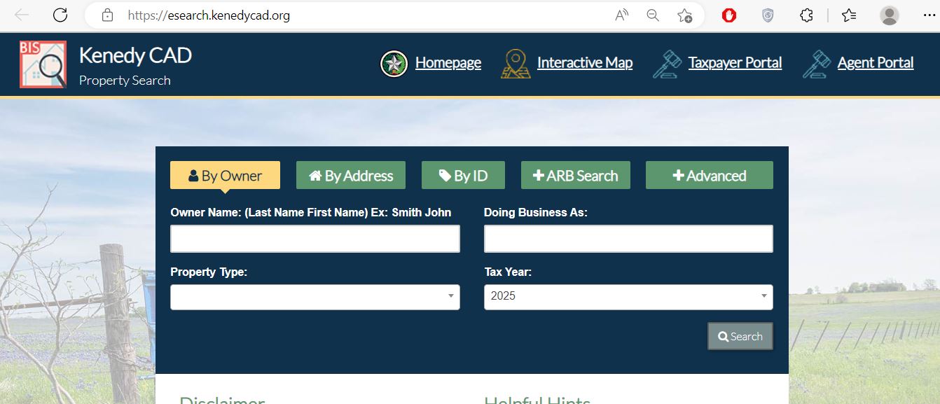
Use the search field that matches the Kenedy County property type
| Search field | Use it when | Important verification |
|---|---|---|
| Owner name | You know a person, ranch entity, trust, estate, company or DBA. | Search one name component and compare every result. |
| Property ID | You copied the account number from a notice, bill or previous search. | Confirm the property type and tax year after opening it. |
| Geographic ID | You are matching a parcel to the map or legal-description record. | Do not treat it as a survey or mineral-title identifier. |
| Abstract | The rural tract is described through an abstract rather than a normal street address. | Match the tract, survey, acreage and deed description. |
| Subdivision | The property is indexed through a subdivision or recorded development. | Match lot, block, phase and legal description. |
| Property type | You need to separate real, personal, mineral, mobile-home or other accounts. | The surface and mineral interests may be separate accounts. |
| Owner ID | You need to find accounts connected to an owner identifier. | Each account separately before combining values. |
| Neighborhood | You are reviewing appraisal grouping or equal-appraisal evidence. | A CAD neighborhood is not necessarily a sales market or ranch boundary. |
| ARB fields | You need protest status, hearing date, informal date or board-member information. | The official hearing notice controls the schedule. |
Understand what a Kenedy CAD property record does and does not prove
| Field | What it identifies | What it does not prove | Best next action |
|---|---|---|---|
| Property ID | The account in Kenedy CAD’s appraisal system. | That the Tax Office or title record uses the same identifier. | Use it when contacting CAD and matching the tax account. |
| Owner shown | The owner carried for appraisal administration. | Complete surface or mineral title. | Review recorded instruments and title evidence. |
| Property type | Whether the account is real, personal, mineral, mobile home or another class. | That all interests connected to the location are combined. | Search other property types for related accounts. |
| Abstract or legal description | The appraisal district’s abbreviated tract reference. | A complete legal description suitable for a deed. | Open the recorded deed, lease, probate record or survey. |
| Acreage | The acreage carried for appraisal purposes. | Surveyed or legally guaranteed acreage. | Compare the deed, survey and title records. |
| Market value | CAD’s opinion of market value as of January 1. | A guaranteed sale price or tax amount. | Review appraisal evidence and property facts. |
| Appraised value | Value after an applicable appraisal limitation or special appraisal treatment. | The value after every exemption. | Continue to taxing-unit taxable values. |
| Taxable value | The value remaining after applicable exemptions. | The live balance, penalty or payment status. | Open the Kenedy County tax search. |
| Productivity value | A qualifying agricultural or wildlife appraisal based on productive capacity. | That the qualification continues after a change in ownership or use. | Verify current qualification and change-of-use exposure. |
| Mineral value | The appraised value carried for a mineral interest account. | Mineral ownership, lease terms, royalty decimal or production entitlement. | Use deeds, leases, division orders and title research. |
Use the Kenedy CAD map for location context—not legal boundaries
Research Kenedy County ranch land beyond the total appraised value
Use property ID, geographic ID, abstract, legal description and map—not a ranch name alone.
Qualifying land may show a much lower productivity value than market value.
Check whether all acreage is classified and valued under the expected agricultural or wildlife use.
Prepare grazing, livestock, lease, wildlife-plan, fencing, water and management records when qualification is questioned.
Homes, barns, tanks, equipment structures and other improvements may be appraised outside productivity value.
A change from qualifying use may create additional tax consequences. Verify the current Texas rule before changing use.
Evidence to keep for agricultural or wildlife appraisal
Search Kenedy County mineral accounts separately from the surface tract
Separate market value, appraised value and taxable value
Kenedy CAD’s opinion of the property’s market value as of January 1 for that tax year.
The value after an applicable appraisal limitation or qualifying special-appraisal treatment.
The value remaining after exemptions. It may differ among county, school, groundwater and emergency-service units.
Fix common Kenedy CAD search problems before calling
| Problem | Likely reason | Practical fix |
|---|---|---|
| Owner name returns no result | The record may use a ranch, trust, estate, company or different name format. | Search only the first or last name, one company word or the property ID. |
| Too many owner matches | The owner has several surface, mineral or personal-property accounts. | Add property type, geographic ID, abstract or tax year. |
| Address search fails | The rural tract may have no normal situs address or use a different road description. | Use the street name alone, owner, property ID, abstract or geographic ID. |
| Mineral record is missing | The search is limited to real property or the mineral account uses another owner name. | Select Mineral property type and search owner variations. |
| Acreage does not match a deed | The appraisal record may be abbreviated, combined, divided or awaiting an update. | Compare recorded deeds and surveys, then contact CAD with documentation. |
| Recently transferred property shows the former owner | The deed or probate transfer may still be processing. | Confirm the recorded instrument and ask CAD what ownership proof is required. |
| Tax search cannot locate the property | The wrong tax year, owner spelling or account type may be selected. | Contact the Tax Office at 361-294-5202 with the property ID and tax year. |
| CAD value and tax balance look different | Appraisal value, taxable value and amount due are separate records. | Use CAD for value and exemption questions; use the Tax Office for the bill. |
Send each Kenedy County question to the source that controls it
| Your question | Best starting point | What to prepare |
|---|---|---|
| What is the market or appraised value? | Kenedy County Central Appraisal District | Property ID, property type, tax year and disputed value. |
| Why is an exemption missing? | Kenedy CAD | Application, qualification date, ID and supporting evidence. |
| Is agricultural or wildlife appraisal active? | Kenedy CAD | Acreage, land-use history, application and management evidence. |
| What is the tax balance? | Kenedy County Tax Assessor-Collector | Property ID, owner, tax year and property type. |
| Did my payment post? | Kenedy County Tax Assessor-Collector | Receipt, confirmation, amount, date and tax year. |
| Who owns the surface estate? | County Clerk, title company or attorney | Grantor, grantee, legal description and recording information. |
| Who owns the minerals? | Title professional or qualified attorney | Mineral deeds, reservations, leases, probate and division orders. |
| What is the legal acreage or boundary? | Surveyor and recorded-property records | Deed, survey, plat, field notes and title evidence. |
| Who sets the tax rates? | Each local taxing unit | Taxing-unit list from the appraisal account. |
Correct the Kenedy County system that owns the inaccurate field
Verify Kenedy County exemptions before estimating property taxes
Confirm that the home is the owner’s principal residence and that the current account displays the exemption.
Review the additional exemption, school-tax ceiling and possible payment or deferral options.
Check qualification documents, the additional exemption and any applicable school-tax ceiling.
Use the correct application and attach the required VA documentation for the claimed category.
Review qualifying use, intensity, history, acreage and productivity value rather than market value alone.
Prepare the current wildlife-management plan, activity records, maps and evidence that the land remains eligible.
Official Kenedy CAD forms currently available
| Form or filing | Who may need it | What to prepare |
|---|---|---|
| Residence Homestead / Over-65 / Disabled Person | Qualifying owner-occupants | Property ID, ownership, occupancy, identification and qualification evidence. |
| Disabled Veteran Exemption | Qualifying veterans or surviving spouses | VA documentation, ownership and residence information. |
| Agricultural Appraisal | Landowners seeking open-space special appraisal | Use history, acreage, maps, leases and production evidence. |
| Wildlife Management Plan | Qualifying land transitioning or continuing in wildlife management | Plan, maps, management activities and supporting records. |
| Personal Property Rendition | Businesses with taxable personal property | Asset list, costs, acquisition dates, inventory and situs information. |
| Notice of Protest | Owners disputing a CAD action | Notice, property ID, protest reason and evidence. |
Prepare a Kenedy CAD protest around one specific appraisal issue
Evidence packet checklist
Prepare for the Kenedy County ARB without contacting a board member about your property
Kenedy CAD publishes 2026 hearing procedures through its official forms and ARB pages.
The notice controls the date, time, location, participation method and submission instructions.
State the requested value or correction first, then explain the strongest supporting evidence.
Move from the Kenedy CAD appraisal account to the county tax ledger
The CAD account explains appraisal values and exemptions. The Kenedy County Tax Assessor-Collector’s search controls the live amount due, payment status and receipt.
Use legal records when the question goes beyond appraisal
| Question | Best record | Why CAD alone is not enough |
|---|---|---|
| Who owns the surface estate? | Recorded deed and title examination | The appraisal owner field is maintained for taxation and may not show every title issue. |
| Who owns the mineral estate? | Mineral deeds, reservations, probate, leases and title opinion | The mineral appraisal account does not prove complete mineral title. |
| What is the legal acreage? | Recorded deed, survey and field notes | CAD acreage is an appraisal field and may be abbreviated or estimated. |
| Where is the boundary? | Professional boundary survey | The public GIS map is not a legal survey. |
| Was property inherited? | Probate orders, wills, affidavits and recorded transfers | The appraisal account may update after the legal transfer process. |
| Is there a lien? | Recorded lien and release search | CAD does not maintain a complete title or lien report. |
| What royalty decimal is payable? | Lease, division order, title opinion and operator records | Appraisal value does not establish payment entitlement. |
Complete these checks before buying or inheriting Kenedy County property
Match property ID, geographic ID, abstract, legal description, map and surveyed acreage.
Do not assume ownership or tax accounts are combined.
Check current and delinquent balances for all related property types.
Confirm agricultural or wildlife qualification and what may happen after ownership or use changes.
The seller’s homestead or other exemption may not transfer to the buyer.
Compare houses, barns, tanks, structures and personal-property accounts with the actual property.
Use recorded deeds, probate records, lien searches and a title commitment or opinion.
Verify boundaries, access, easements and acreage before relying on CAD mapping.
Keep the deed, title policy, survey, tax certificate, closing statement and exemption filings.
Important Kenedy County property-tax dates
Kenedy County appraisal and tax offices in Sarita
Sarita, Texas 78385
Mailing: P.O. Box 39, Sarita, Texas 78385-0039
Phone: (361) 294-5333
Fax: (866) 303-6553
Email: appraiser@kenedycad.com
Chief Appraiser: Thomas G. Denney, RPA
Hours: Monday-Thursday 9:00 AM-4:30 PM; closed 12:00 PM-1:30 PM for lunch. Friday 9:00 AM-12:00 PM.
Sarita, Texas 78385
Mailing: P.O. Box 129, Sarita, Texas 78385-0129
Phone: (361) 294-5202
Fax: (361) 294-5710
Email: taxoffice@kenedycountytx.gov
Tax Assessor-Collector: Irma G. Longoria
Hours: Monday-Friday 8:00 AM-4:00 PM; office remains open during lunch.
Sarita, Texas 78385
Main phone: (361) 294-5224
Use the courthouse directory to confirm the correct records office for deeds, probate, liens or certified county documents.
Prepare the property ID, owner, property type, abstract, legal description, tax year and a short explanation of the task.
Call first to confirm holiday closures, required documents, accepted payment and whether the requested record is available online.
Official Kenedy County property resources
Use for appraisal information, meetings, tax resources, contacts and official announcements.
Open Kenedy CADSearch owner, ID, ARB and advanced appraisal fields.
Open property searchReview approximate parcel, ranch and surrounding-property context.
Open the mapFind exemption, agricultural, wildlife, rendition, protest and appraisal-roll resources.
Open forms and reportsUse for supported owner and electronic-communication services.
Open Taxpayer PortalAuthorized property-tax agents can access agent appeal services.
Open Agent PortalSearch current accounts, balances and online payment access.
Open tax searchVerify balances, payment status, receipts and office procedures.
Open the Tax Office pageReview taxing-unit rates, notices and property-specific tax information.
Open tax-rate portalCross-check CAD, tax office and active taxing-unit information.
Open Kenedy County directoryReview Appraisal Review Board guidance, meetings and current hearing procedures.
Open ARB informationReview the appraisal district’s electronic-communication request process.
Open communication requestHow this Kenedy County guide was improved and reviewed

Independent research focused on rural, ranch and mineral property
This version preserves the image already used on the existing page while replacing the earlier overview with complete property-search instructions, map warnings, account-field explanations, ranch and mineral workflows, exemption guidance, protest preparation, tax-payment verification and legal-record routing.
Official resources reviewed include Kenedy County Central Appraisal District, Kenedy County Tax Assessor-Collector, the Texas Comptroller county directory, the live appraisal and tax portals, 2026 forms, appraisal-roll downloads and ARB materials.
AppraisalDistrict.org is an independent informational website and is not operated by Kenedy County Central Appraisal District or Kenedy County.
10 common Kenedy County appraisal and property-search questions
1. What is the official Kenedy County Appraisal District website?
The official website is kenedycad.org. Use it for property search, maps, forms, reports, taxpayer services, exemptions and protest information.
2. How do I search Kenedy County property records?
Use the official Kenedy CAD property search. Search by owner or property ID, or use Advanced Search for property type, abstract, subdivision, owner ID, geographic ID and other filters.
3. Why does a Kenedy CAD owner or address search return no result?
The account may use a ranch, trust, estate, company or mineral-owner name, and rural land may not have a normal address. Search one name word, property ID, geographic ID, abstract or legal description.
4. Can Kenedy CAD acreage or map boundaries be used in a deed?
No. The official search warns that legal descriptions and acreage are for appraisal-district use and should be verified before legal use. Obtain recorded documents and a professional survey.
5. Does Kenedy County Appraisal District collect property taxes?
No. Kenedy CAD handles appraisal, exemptions, special valuations and protests. The Kenedy County Tax Assessor-Collector handles tax bills, payments and receipts.
6. How do I pay Kenedy County property taxes online?
Use the official Kenedy County tax search. Confirm the property, property type, tax year and balance, review the fee and save the payment confirmation.
7. What is the Kenedy County protest deadline for 2026?
Most protests are due by May 15 or by the 30th day after Kenedy CAD mails the Notice of Appraised Value, whichever is later. Use the deadline printed on the individual notice.
8. How do I verify a Kenedy County homestead exemption?
Open the complete property account and review the exemption and taxable-value fields. If an expected exemption is missing, use Kenedy CAD’s official forms or contact the district and keep proof of filing.
9. How do I search a Kenedy County mineral account?
Use Advanced Search and select the mineral property type. Search the owner, property ID, geographic ID, abstract or other account description. Do not assume the surface and mineral interests share one account.
10. Where is Kenedy County Central Appraisal District located?
Kenedy County Central Appraisal District is at 365 La Parra Avenue, Sarita, Texas 78385. The phone number is (361) 294-5333, and the mailing address is P.O. Box 39, Sarita, Texas 78385-0039.